Utah breaks all-time snow record

Add Axios as your preferred source to
see more of our stories on Google.
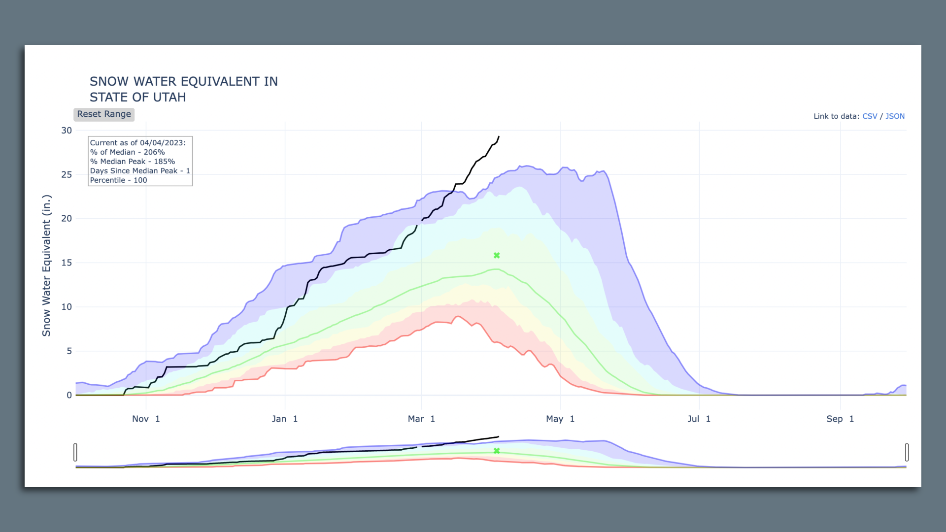
The black line shows this year's snowpack — the highest since the measurement system was created in 1981, and higher than the previous record set in 1952. Chart via USDA Natural Resources Conservation Service
This week's winter storm broke Utah's all-time snowpack record on Tuesday — probably.
Between the lines: New measurement systems make it a little hard to compare this winter to one in 1952.
Driving the news: Utah's statewide "snow-water equivalent" — the depth of the water that melted snow would produce — averaged 29.4 inches as of Tuesday morning, surpassing a previous record of 28.8, set in 1952.
Yes, but: The 1952 record was set when measurements were taken once a month, from fewer locations, said Jordan Clayton, snow supervisor for the USDA in Utah.
- That means the snowpack in 1952 could have been higher if it peaked between measurements.
By the numbers: Of the 61 measurement stations used in 1952, 47 are still in use today, Clayton told Axios.
- Their average was exactly 29 inches as of Tuesday morning with snow still falling — so the closest comparable calculation also shows a new record.
Another view: This winter's accumulated snowfall — which is different from the snowpack water equivalent — reached 78.5 inches on Tuesday at Salt Lake's airport, according to the National Weather Service.
- Though well above normal, that's still less than 1952's 117.3 inches.
Zoom out: The snowpack measurements, by contrast, reflect statewide conditions — and southern Utah's mountains are heavily blanketed, with temperatures well below normal and snow still falling, Clayton noted.
- This year has brought record snow accumulation to the mountains near Moab, with near-record snowfall near Bryce Canyon and Lake Powell.
- Record snow accumulation also is reported in Grantsville and sites in Cache and Rich counties, with near-record snow in Weber and southern Utah counties.
Why it matters: With 95% of Utah's water supply coming from melted snow, this winter is going a long way to replenishing reservoirs and the imperiled Great Salt Lake.
- The state's reservoirs were 32.4% full as of Tuesday — well below the median of 58% thanks to multiple years of drought and growing water use.
- The Great Salt Lake remains about 6 feet below normal, per federal data.
Catch up quick: Last month, the snowpack broke the record under the current measurement system — 26 inches in 1983.
- Multiple ski resorts have shattered accumulation records, with Snowbird joining them on Tuesday when it tallied 785 inches for the season.
What we're watching: Spring thaw will likely bring flooding, state officials have warned, and it's expected to warm up quickly after today.
- Mountain temperatures are projected to reach the 50s early next week.
- Gov. Spencer Cox on Monday declared April to be "Flood Safety Awareness Month."