Utah's cycle of drought and record winds could cause big problems

Add Axios as your preferred source to
see more of our stories on Google.
/2022/07/06/1657145880520.gif?w=3840)
Illustration: Aïda Amer/Axios
It's not your imagination. This has been the windiest spring and early summer Salt Lake has seen since at least the 1950s.
- And the damage could be severe if it doesn't calm down soon.
Driving the news: For months, wind gusts have been faster on average than weather watchers have previously documented, according to an Axios analysis of federal wind data.
- The average daily peak gusts for the past four months are the highest of any four-month period since at least 1954, the earliest year recorded in the Global Historical Climatology Network's data for the airport weather station.
Why it matters: The wind can wreak havoc — especially in summer.
- It has been making wildfires increasingly hazardous as they shut down highways and threaten neighborhoods.
- The wind also churns up dust storms and could erode the crust covering toxic soil in the drying bed of the Great Salt Lake, which reached a historic low this week.
What's happening: Spring is always windy — but Utah's drought could explain the persistent winds into June, said Jon Wilson, a meteorologist with the National Weather Service in Salt Lake City.
- Warm, dry conditions likely caused the summer monsoon season to begin early in the Four Corners region, which brought summer thunderstorms north earlier than they'd usually arrive.
- When thunderstorms occur in drought conditions, the rain can evaporate before it reaches the ground, in what's known as "dry thunderstorms."
- The evaporation cools the air, causing it to move downward and fan out into wind gusts.
Even before summer, high winds were damaging trees, further deteriorating the shade canopy that would have protected neighborhoods from Utah's ferocious sunshine as temperatures rise.
- 2021 brought the third-windiest December by average peak gust, and the fifth-windiest October.
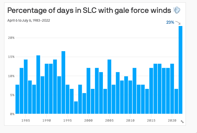
By the numbers: Gusts exceeded 39 mph — the definition of "gale" winds — on more days during the past three months than any other three-month period since 1967.
- May and June individually posted the highest peak gust averages of any May or June in recorded history.
- April's average was the fastest since 1967, and the third-highest year on record. The first five days of July brought the fastest average since 1971.
What's next: Unfortunately, there's no sign that the monsoon season or the drought will end anytime soon.
- That means conditions will remain favorable for dry thunderstorms into July and August, bringing wind — and lightning that could start wildfires.
Yes, but: If the monsoon sends enough moisture our way, it could disrupt the cycle of dry thunderstorms and give us a break from the wind, along with much-needed rain that actually reaches the ground.