New voting maps aim to bridge Portland's east/west divide

Add Axios as your preferred source to
see more of our stories on Google.

Illustration: Allie Carl/Axios
Three draft maps of Portland's future city council voting districts are circulating around the city, posing one big question: Which chunk of Portland's east side should be joined with the west side?
Why it matters: In 2024, Portland will stop electing council members citywide and instead vote by district for the first time, per charter amendments voters approved last year.
- The volunteer mapmaking commission is trying to keep communities with shared interests together.
Driving the news: "This is a historic moment for the city," Josh Laurente, co-chair of the Independent District Commission, told Axios. "We're working on a very fast timeline."
- Commissioners are accepting public comment on the proposed district lines until July 22, and must finalize district lines no later than Sept. 1.
How it works: In addition to keeping people with common interests together — such as shared school districts, socioeconomic groups or ethnic communities — the commission drawing the lines also tried to follow existing geographic or political boundaries.
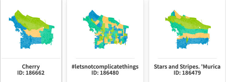
Details: One district remains the same across all three draft maps: the farthest-east district, uniting the Lents neighborhood and Jade District with communities east of I-205.
- The two districts that make up the rest of Portland's east side are drawn slightly differently on each map, trading neighborhoods along Sandy Boulevard.
- The west side of Portland is all in one district, but its population falls short, so roughly 20,000 east-siders need to be added on.
What they're saying: "Each of these maps are offering a different rationale for how to best connect east side communities to that west side district," Laurente said.
- One, prioritizing neighborhood boundaries and demographic similarities, adds the far southern neighborhoods of Sellwood and the Reed College area.
- Another, prioritizing transportation connections, adds a skinny line along the river from Sandy to Portland's southern edge.
- The third gives a chunk of the central east side to the west side voting district.
Context: The final map will include four voting districts, which in 2024 will pick three city council members each.
- Portland's new city council will have 12 members, up from five now.
The intrigue: In addition to putting out three draft maps of their own, the commissioners have been looking at nearly 200 maps drawn by other Portlanders.
Reality check: Anything that is really different from four contiguous quadrants is a non-starter.
- "Some of those maps that were submitted just don't meet the criteria," Laurente said. "I think some of them were just folks having fun with the mapping tool."
What's next: There are five more opportunities to contribute your thoughts in person or online — one each day starting Wednesday evening and ending on Sunday.
- An online survey is open through July 22.
The bottom line: Whatever map is finalized now will be used for city elections until 2030, when they'll start to be updated after each census.