North Texas is no longer in a drought

Add Axios as your preferred source to
see more of our stories on Google.

Illustration: Brendan Lynch/Axios
Last week's rainfall significantly helped reduce most of North Texas' drought risk.
Driving the news: The U.S. Drought Monitor releases new data every week to show how different parts of the country are affected by varying levels of drought.
The big picture: North Texas was labeled as abnormally dry or in a drought until late November, but the Drought Monitor's new map from yesterday shows improvement across the region since last Thursday.
Why it matters: The recent rain should bring some relief after months of dry conditions that were slowing crop production, increasing the risk of grass fires and drying up pastures for cattle.
- The Texas drought was also blamed for record-setting cattle sales earlier this year.
Threat level: Before last week, parts of central Texas were in extreme drought, and the San Antonio area was experiencing exceptional drought conditions that accounted for lower honey production and burn bans.
- Dallas County was doing OK, but Denton, Tarrant, Johnson and Ellis counties were abnormally dry.
- The western parts of Tarrant and Johnson counties were in a moderate drought, one level above abnormal dryness.
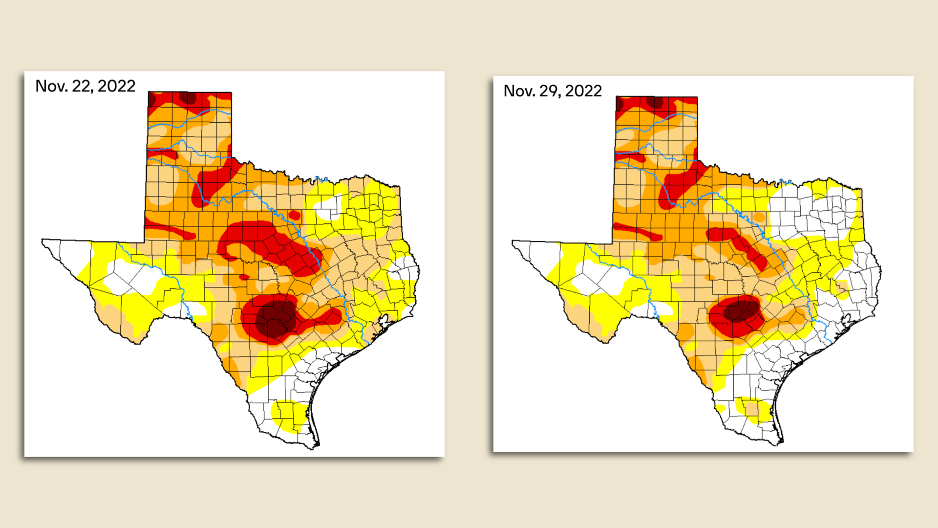
State of play: Most of the counties in North Texas are no longer experiencing dryness or drought, and the state's most intense drought conditions are southwest of Austin, per the U.S. Drought Monitor.
Of note: August and November were abnormally wet months for North Texas, according to the National Weather Service.
- 10.7 inches were recorded at DFW Airport in August, the wettest August in over 100 years. And most of that came in one day.
- We got another 6.4 inches of rainfall last month, the wettest November since 2015, with almost double the rainfall than last November.
Yes, but: Despite all of the rain in August and November, it took a while to reverse our region's drought conditions because the rain was addressing a large deficit at first.
- "We've got to look at not just where or how much it rains, but how much of a deficit we have as well," Juan Hernandez, a meteorologist with the National Weather Service's Dallas-Fort Worth office, tells Axios.
The big picture: The National Weather Service expects La Niña conditions to persist throughout the winter and account for below-average precipitation for the southern part of the country, from California to Florida.
What's next: Get ready for a "temperature roller coaster" in North Texas, Hernandez says. Current projections for the next few weeks show warmer-than-usual temperatures mixed in with cold fronts, he says.