Inundated Midwest faces fresh flood threats


Add Axios as your preferred source to
see more of our stories on Google.
High water levels at the Rapidan Dam on the Blue Earth River in Mankato, Minnesota, on Monday. Photo: Ben Brewer/Bloomberg via Getty Images
Midwest residents hit by historic flooding face the threats of further inundation into Tuesday, with officials in Minnesota particularly concerned that the Rapidan Dam in Mankato is in "imminent failure condition."
The big picture: At least one death has been reported in South Dakota and another in Iowa from days of flooding rains that have forced a town to evacuate and collapsed a bridge connecting Sioux City, Iowa, with North Sioux City, South Dakota.
State of play: The National Weather Service warned on Monday the ongoing extreme heat wave that's gripped much of the U.S. would affect parts of the inundated upper Midwest as a severe weather outbreak threatened parts of Minnesota, Wisconsin and Illinois.
- President Biden approved Iowa Gov. Kim Reynolds' request for a disaster declaration and "ordered Federal aid to supplement State, tribal, and local recovery efforts in the areas affected by severe storms, flooding, straight-line winds, and tornadoes beginning on June 16, 2024, and continuing," per a Monday night White House statement.
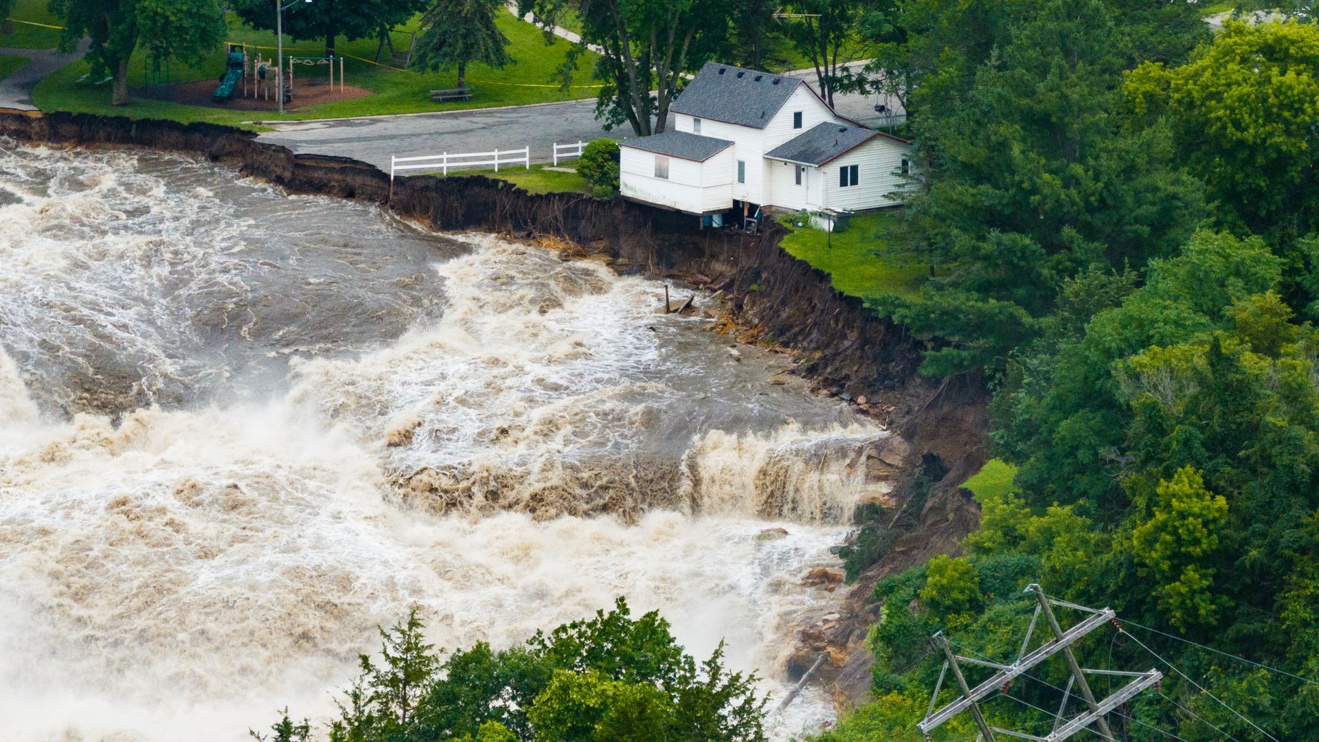
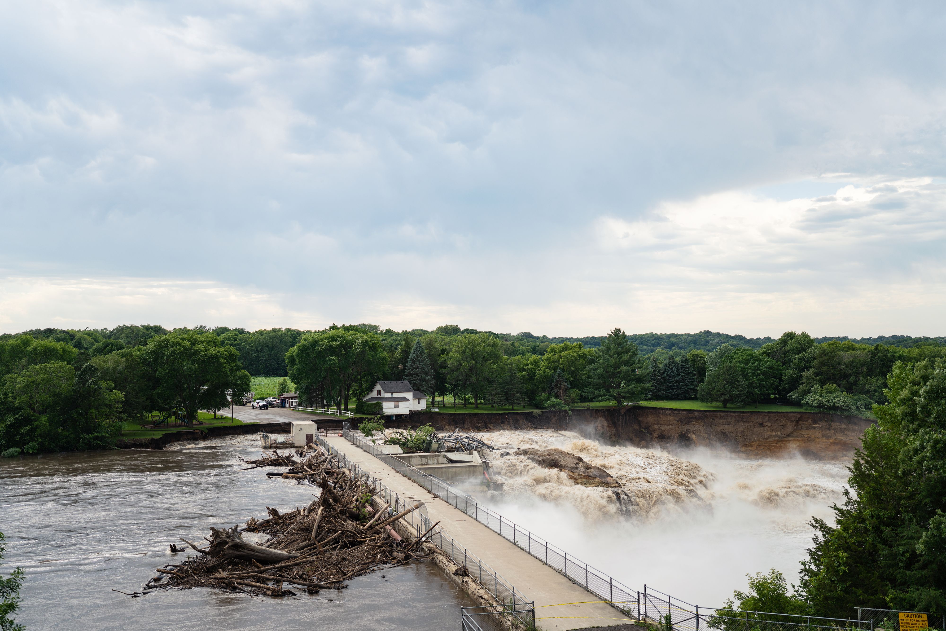
- In Minnesota, a flash flood warning remained in effect for the area around the breached 100-year-old Rapidan Dam over the Blue Earth River in the south central part of the Land of 10,000 Lakes through 10:30am Tuesday local time.
- The heavy rains and concerns of potential flash flooding due to the ongoing inundation prompted the NWS' Twin Cities office to issue a flood watch across the Twin Cities metro and portions of south Minnesota and west Wisconsin on Monday evening.
Zoom in: The Blue Earth County government said in a Monday Facebook post that it became "aware of accumulating debris at the Rapidan Dam" near Mankato on Sunday.
- It was unclear whether the dam "will totally fail or if it will remain in place, however we determined it was necessary to issue this notification to advise downstream residents and the correct regulatory agencies and other local agencies," the government added.
- The Blue Earth County Sheriff's Office said in a Facebook post later Monday that the dam was "still intact" and there are no immediate plans for a mass evacuation, but there had been a "partial failure on the west abutment."
Threat level: Severe storms and flash flooding were possible for portions of the Upper Midwest into Monday night and shifting "a bit south" on Tuesday due to locally heavy downpours, per a National Weather Service forecast discussion on Monday afternoon.
- There was an enhanced risk (level 3/5) of severe thunderstorms across eastern Minnesota and western Wisconsin Monday evening.
- "Deep moisture flowing northward ahead of the system will bring increasing storm chances through tonight, while hot temperatures along with the plentiful moisture will lead to strong to extreme instability," the NWS said.
- This prompted an Enhanced Risk of severe weather (level 3/5) from the NWS' Storm Prediction Center.
- "Tornadoes and large hail are possible with the storms, but the primary threat is a corridor of very high wind across southern Wisconsin and surrounding states," the NWS said.
What's next: The NWS is also forecasting more heavy rains across the Midwest, including Minnesota, on June 27-28 and again on July 1st.
Context: Climate change is altering the frequency and severity of extreme precipitation that leads to flooding.
- This week's flooding was initially spurred by a "ring of fire" pattern whereby thunderstorms erupted around the edges of the heat dome — where the temperature contrasts plus frontal zones, with jet stream energy present.
- Climate change is also making heat waves like this one that's swept North America for the past two weeks more likely, more intense and longer lasting.
Go deeper: Sign up for Axios Twin Cities
Editor's note: This article has been updated with new details throughout.
