Unrelenting heat wave shifts focus to Central and Southeast U.S.

Add Axios as your preferred source to
see more of our stories on Google.
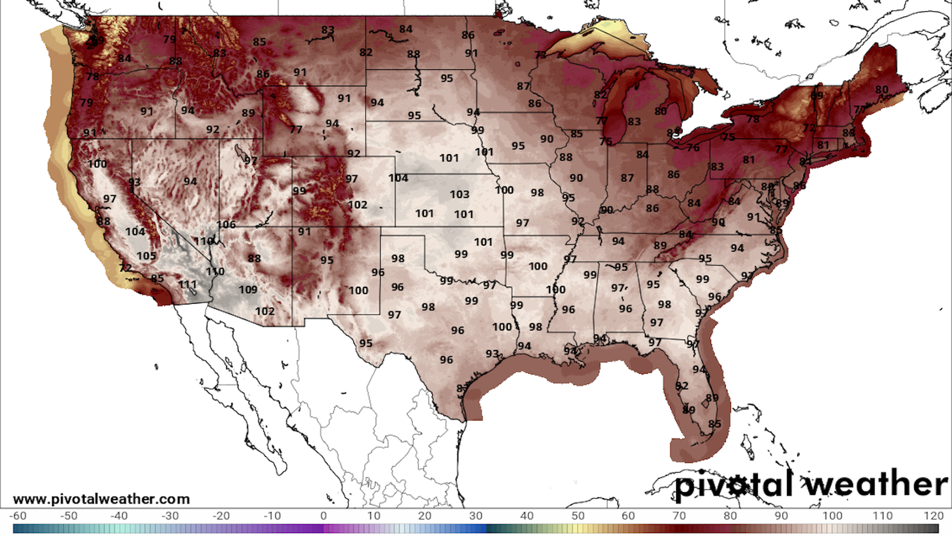
Map showing forecast high temperatures for July 24 across the Lower 48 states. Image: Pivotal Weather.
The climate change-enhanced heat wave responsible for breaking dozens of records across the U.S. and Canada in the past two weeks is taking aim at areas from the Southeast to the Plains.
Why it matters: The move will bring extreme heat to tens of millions of people who have not experienced it yet, with resulting health hazards.
Threat level: With the Northeast and Mid-Atlantic cooler after a cold front swept through Sunday, the heat dome will meander and send temperatures climbing across areas from northern Florida to South Dakota.
- Daily high temperatures are forecast to be in the upper 90s°F to low 100s°F, with heat indices (what it feels like) reaching as high as 110°F, according to the National Weather Service.
- "The arrival of this more intense heat early in the Summer season leads to a higher level of heat-related stress, especially for those outdoors and without reliable air conditioning available," the NWS said Monday morning.
Context: Climate change is making heat waves like this one more likely, more intense and longer lasting—in some cases quintupling the odds of extreme temperatures.
- The heat wave is especially dangerous due to near-record to record warm overnight minimum temperatures, which prevents the human body from cooling down, and increases the chances of heat illness.
- Climate change is predicted to make overnight minimum temperatures throughout the South and Southeast during the next few nights at least five times more likely to occur now than in the preindustrial era.
- This is according to Climate Central's Climate Shift Index, which measures the influence of climate change on daily average and overnight minimum temperatures. It is run in real-time and is based on peer reviewed methods.
Zoom out: The extreme heat has also led to repeated rounds of heavy rains in parts of the Midwest, with many river gauges registering record high levels. Communities have been flooded, at least one person killed and evacuations ordered in Illinois, Minnesota, Wisconsin, Nebraska and Iowa.
- The heavy rains have occurred around the edges of the heat dome, where temperature contrasts are heightened, and jet stream energy helps support severe weather.
- Such a weather pattern is often referred to as a "ring of fire," since thunderstorms surround the heat dome, while the high pressure area itself squelches precipitation closer to the hottest air.
What's next: The heat will last the longest in the South-Central states, including Oklahoma and Texas, and into the Southeast.
- It will make a one-day advance up the East Coast, too. The Mid-Atlantic region may see temperatures increase once again into the mid-90s on Wednesday, with a heat index considerably higher.
