45 million from the Plains to Midwest face severe thunderstorm threat


Add Axios as your preferred source to
see more of our stories on Google.
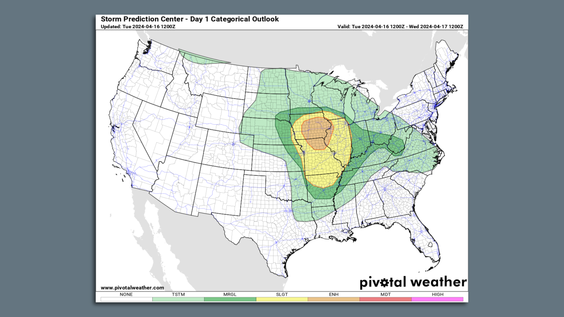
Severe thunderstorm outlook for April 16. Image: NOAA via Pivotal Weather
Some 45 million Americans are at risk of severe thunderstorms from Nebraska through parts of the Midwest and south-central states from Tuesday through Thursday.
The big picture: The National Weather Service's Storm Prediction Center issued an enhanced risk (level 3/5) of severe thunderstorms for parts of Iowa, northern Missouri and Illinois Tuesday.
- As of early afternoon Tuesday, tornado watches covered nearly all of Iowa, northern Missouri, and western Illinois, indicating the conditions were favorable for the formation of tornadoes, among other severe weather hazards.
- Des Moines, Cedar Rapids, Davenport and Iowa City are each in the enhanced storm risk zone Tuesday into Tuesday night.
What they're saying: "These storms will pose a threat for very large hail, damaging winds, and tornadoes, including the risk for a strong tornado," the NWS warned in a forecast discussion Tuesday morning.
Zoom out: On Sunday evening, a line of damaging severe thunderstorms struck much of Pennsylvania. While April typically marks the start of severe weather season in much of the U.S., this was unusually early for such a damaging line of storms so far north and east.
Context: While it does not get the same amount of attention as tornadoes do, large hail can cause large economic losses from damaged cars, homes and crops.
- Last year such losses were notably high across the U.S., costing insurers billions.
- Storms with large, damaging hail, high winds and possible tornadoes were more likely from Texas northward into Nebraska through Monday night, where watches went into effect.
- On Monday afternoon, severe thunderstorms with half-dollar-sized hail blew through the D.C. suburbs in northern Virginia, and those storms subsequently took aim at Richmond.
Between the lines: Above average air temperatures have enveloped the Plains, Midwest and portions of the Mid-Atlantic ahead of an area of low pressure moving eastward into the Midwest.
- Highs in the 70s and 80s will be widespread across the severe weather region, and throughout an even broader area beyond it, the NWS stated.
What we're watching: The SPC noted in its discussions that the exact extent and severity of the tornado risk in particular was uncertain, as some, but not all, of the ingredients for a widespread severe weather outbreak looked to be present Tuesday.
The bottom line: Climate change is increasing the frequency and magnitude of precipitation extremes, studies show.
- It is also making heat waves more likely, intense and longer lasting.
Go deeper: Pittsburgh streets flooded as severe storms threaten Ohio Valley, Mid-Atlantic
Editor's note: This story has been updated with the latest forecast information.
