New Orleans could get 8 inches of rain this week

Add Axios as your preferred source to
see more of our stories on Google.
/2025/05/05/1746466982520.gif)
New Orleans and the rest of south Louisiana are in for a wet week, with the National Weather Service cautioning residents about street flooding.
Why it matters: Heavy rainfall can overwhelm drainage systems and strand drivers in low-lying areas.
The big picture: The rain is expected to start Tuesday morning and stick around through Friday, NWS says.
- New Orleans will most likely get 3 to 4 inches, but forecasters say there's a potential for up to 8 inches.
- Baton Rouge could get up to 10 inches.
Timing: The rain is expected to increase throughout the day Tuesday with heavy rain expected overnight, NWS says.
- Wednesday "should be a bit of a reprieve but there will still be showers," the long-term forecast says.
- More heavy rain is expected Thursday, according to the weather service. Friday should be drier, with storms arriving in the evening.
- The rain is expected to clear out Saturday morning.
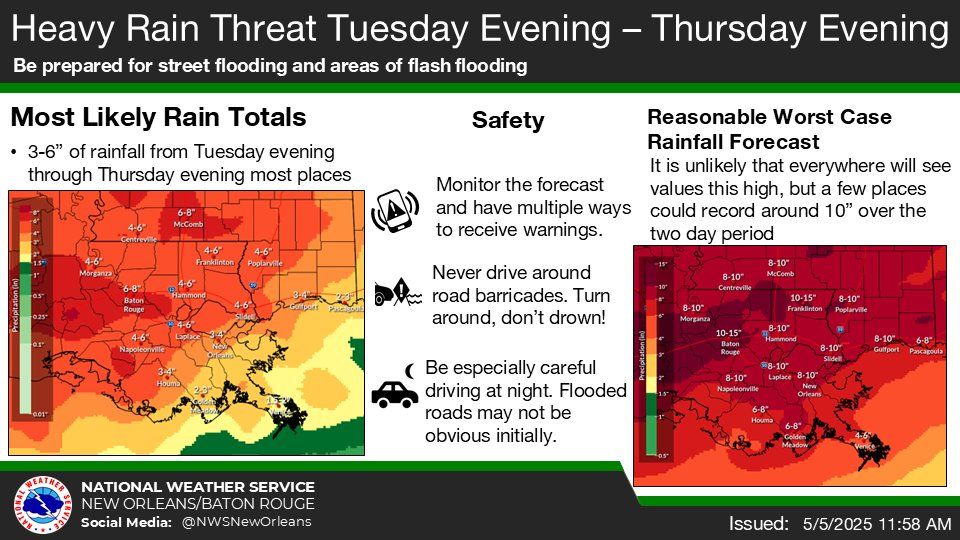
Threat level: New Orleans metro is under a flood watch from 7pm Tuesday to 7pm Thursday.
- The rain could flood underpasses and other low-lying areas, NWS says.
- Don't drive through floodwaters, authorities say, as it is hard to determine the water depth, especially at night.
- During last month's thunderstorm that dropped nearly 10 inches of rain in Algiers, at least one vehicle wound up in a canal and many others were stranded on General De Gaulle Drive, Terry Parkway and other major thoroughfares.
Zoom in: The New Orleans Sewerage and Water Board says it has 88 of 93 major pumps available to drain the city.
- Check the pumps in your neighborhood.
What's next: See the latest forecast and track street flooding in New Orleans.