Hurricane watch for New Orleans: What to know Tuesday


Add Axios as your preferred source to
see more of our stories on Google.
/2024/09/10/1725984414999.gif)
New Orleans is under a hurricane watch ahead of Tropical Storm Francine's landfall in Louisiana as a potential Category 1 hurricane.
Why it matters: The latest track shift means hurricane conditions are now possible in New Orleans — flash flooding, strong winds and storm surge.
The big picture: Gov. Jeff Landry declared a state of emergency ahead of Francine's landfall, which is expected Wednesday afternoon or evening.
- He also requested a federal declaration Tuesday, saying the storm "is of such severity that an effective response is beyond the capabilities of the state and local governments."
- Morgan City, Houma and Louisiana's coast are forecast to get the worst of the storm on its current track. The path shifted again Tuesday afternoon, inching closer to New Orleans.
- Louisianans should prepare to stay home Wednesday and Thursday, leaders say. Clear your catch basins and check on neighbors, they encourage.
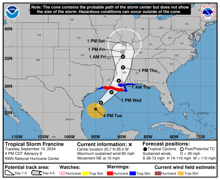
Zoom in: Francine is expected to become a hurricane Tuesday night in the Gulf of Mexico as it heads toward Louisiana.
- Forecasters no longer expect it to reach Category 2 status, as of the 4pm update from the National Hurricane Center.
- Hurricane, storm surge and tropical storm watches and warnings are in effect from westernmost Louisiana to coastal Mississippi. New Orleans is under a tropical storm warning and hurricane watch.
- Go deeper for more about the forecast.
"Won't be Ida"
State climatologist Jay Grimes urged residents to finish prepping Tuesday before the "real action" kicks in Wednesday with the storm.
- "It won't be Laura," he said during a statewide briefing with the governor. "It won't be Ida, but it still will be an extensive impact."
The track continued nudged a little east Tuesday afternoon, putting metro Baton Rouge and New Orleans at risk.
- "Storms wobble. It's what they do," Landry said, adding that he's confident the state's resources are still pre-positioned in the best places to help during and after the storm.
- The Louisiana National Guard is also mobilizing and focusing on high-water vehicles, boats and helicopters that may be used during search-and-rescue operations.
Rush for gas, groceries
Gas station lines were long Monday and Tuesday as residents topped off their tanks and got gas for generators.
- Several drivers told Axios they were doing it just in case and weren't planning to evacuate. Most mentioned Hurricane Ida's extended blackout and wanting to be prepared.
Customers were stocking up at Rouses too.
- Jennifer and Todd Marshall said they were getting their regular groceries, except for frozen goods, and adding more drinks.
- See more prep photos from around New Orleans.
Closures and storm prep
Many schools are closed Wednesday in metro New Orleans.
- Full list from WWL.
- Audubon Nature Institute says the zoo, aquarium and its other facilities are closing Wednesday too.
At the lakefront, Tulane's sailing team was moving more than 40 boats to the other side of the levee in hopes of keeping them safe, coach Charles Higgins told Axios.
- And, the Southern Yacht Club on Tuesday was flying its red and black storm warning flag. A generator was running a large water-filled barrier to protect the ground floor from storm surge along Lake Pontchartrain.
- The winds were picking up at the lighthouse, but Lakeshore Drive was still passable Tuesday morning.
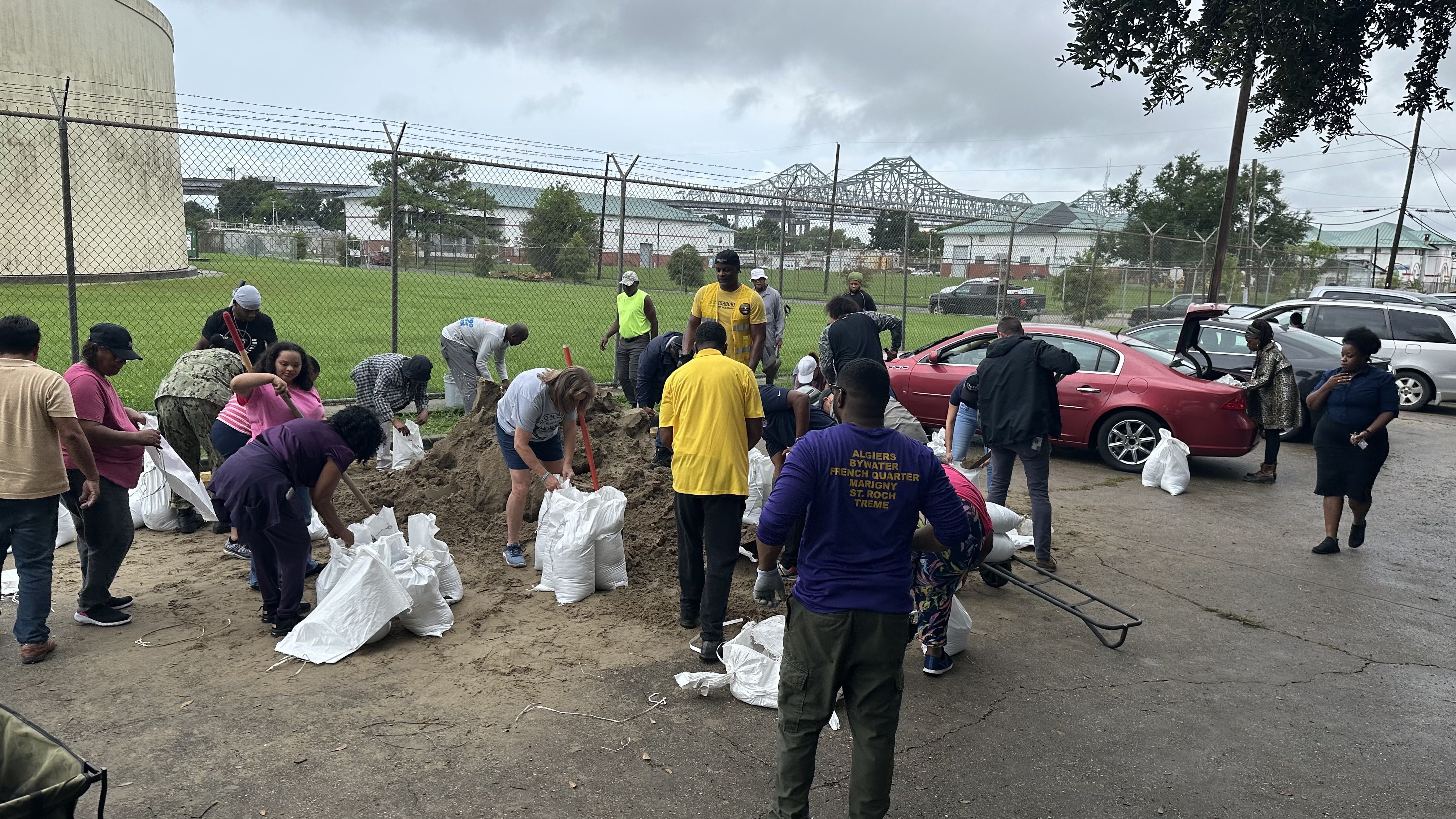
A steady flow of cars kept the parking lot of the Arthur Monday Senior Center in Algiers full as a couple dozen residents and volunteers, including New Orleans City Council-members Helena Moreno and Freddie King, filled sandbags. They disappeared about as quickly as they were tied off.
What she said: "I was feeling really good, which is unfortunate for the folks to the west of us, but now I don't know," New Aurora resident Tammy Crumpton told Axios New Orleans as she piled half a dozen sandbags into the trunk of her car.
- Crumpton hadn't planned to leave but admitted the option was back on the table because she worried about how unpleasant New Orleans can be after a storm passes through.
- "When I see this is coming at us, we may have to deal with flooding, but we also have to deal with infrastructure," she said.
Jim Cantore in New Orleans
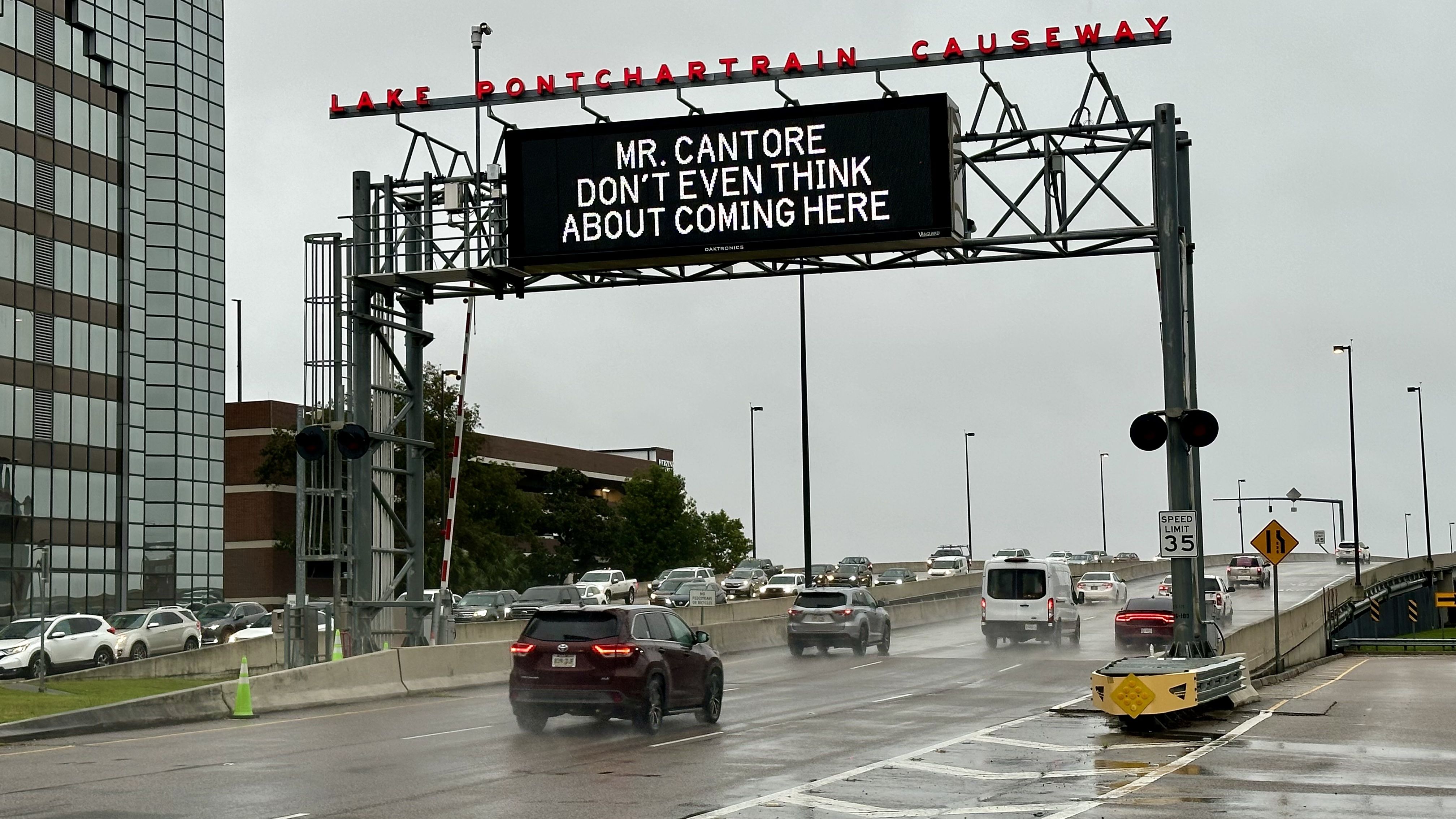
Jim Cantore, The Weather Channel's meteorologist we all love to hate during hurricane season, tells Axios he's in New Orleans on Tuesday.
- "But I'm leaving today," he tweeted.
- The Weather Channel says he's heading to Morgan City to report on the storm.
Yes, but: The folks at the Lake Pontchartrain Causeway had some thoughts for Cantore.
- "Mr. Cantore don't even think about coming here," the sign on the South Shore read Tuesday morning.
- It's not the first time they've poked at Cantore.
What to expect in New Orleans
Here's what the National Weather Service says we can expect in New Orleans from Francine.
Rain: 4-8 inches of rain could fall through Thursday, with more in localized areas.
- The ground is already saturated from last week's rain, so flash flooding and runoff are more likely.
Wind: Winds of 15 to 25mph are possible, with gusts up to 45mph. They could reach the city overnight, but the mostly likely arrival is Wednesday morning.
- Scattered power outages are possible, along with hazardous driving conditions on bridges.
Storm surge: A storm surge up to 5 feet is possible on Lake Pontchartrain and Lake Maurepas.
- That means some roads and parking lots around the lake may see some water, like Lakeshore Drive, West End Park, Breakwater Park and around Lakefront Airport.
Tornadoes: There's potential for a few tornadoes. Terrytown Playground is opening as a shelter for Jefferson Parish residents who live in mobile homes.
What we're watching: The National Hurricane Center's next Francine update is at 7pm.
Editor's note: This is a developing story and will be updated.