"Catastrophic" Hurricane Helene lashes Georgia after Florida landfall


Add Axios as your preferred source to
see more of our stories on Google.

Satellite view of Hurricane Helene as it intensified over the Gulf of Mexico on Sept. 26. Image: CIRA/RAMMB
Editor's note: Read our latest coverage on Hurricane Helene.
Hurricane Helene made landfall in Florida's Big Bend region as a Category 4 storm late Thursday before moving into Georgia with "catastrophic winds" as a still-dangerous high-end Category 2 hurricane early Friday.
The big picture: The deadly hurricane weakened to a Category 1 storm by 2am ET, but "life-threatening storm surge," winds and heavy rains continued amid multiple water rescues across Florida.
- There's been at least one storm-related death in the state and two others in Georgia since the strongest storm ever recorded in the Big Bend coast struck.
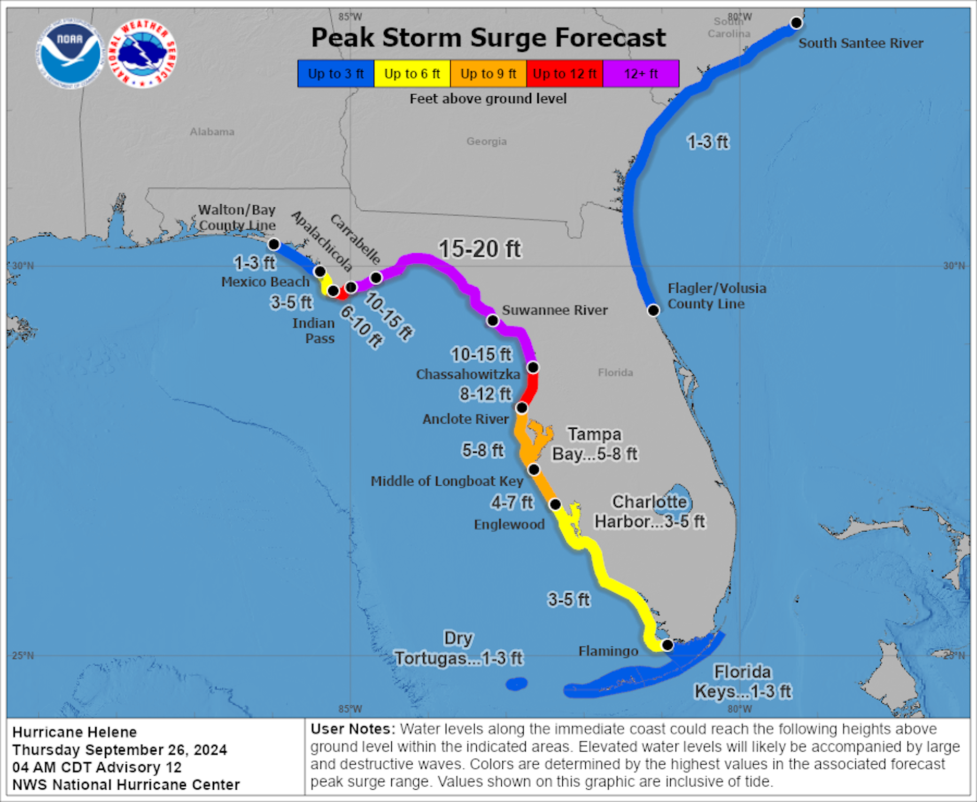
Threat level: The huge storm was forecast to bring an unprecedented 15- to 20-foot storm surge to Florida's Big Bend area and high winds to all of the state, as the storm plowed inland with hurricane-force wind gusts hitting north Georgia. Hurricane warnings were in effect for parts of metro Atlanta.
- The National Weather Service called the maximum storm surge forecast for the Big Bend region "catastrophic and unsurvivable." The surge has already begun along the west coast of the state.
- Flooding rains were affecting the southern Appalachians, with rainfall totals around 15 inches expected in western North Carolina. Such rainfall amounts will cause landslides and historic flooding.
- Tampa Bay was forecast to see one of its most severe storm surge events on record, with up to 8 feet of surge.
The Atlanta metro area faced one of its most significant encounters with a hurricane or tropical storm on record, with hurricane-force wind gusts anticipated.
- These winds could lead to widespread tree damage.
State of play: The hurricane rapidly strengthened into a Category 4 storm over the Gulf of Mexico's record-warm waters Thursday and continued to gain intensity ahead of landfall Thursday night to the south-southeast of Tallahassee.
- The eye of the storm made landfall just east of the mouth of the Aucilla River, about 11:10pm, per the National Hurricane Center. Maximum sustained winds were estimated to be at 140 mph.
- The National Hurricane Center noted the storm size was at the "upper bound" of all storm sizes observed in the Gulf of Mexico.
- The storm's center was located about 30 miles north of Valdosta and was moving "quickly" north-northeast at 26 mph as of 2am ET, per the NHC.
- Top sustained winds were at 90 mph.
- Nearly 1.3 million customers were without power in Florida and another 367,000-plus others had no electricity in Georgia early Friday, per utility tracker poweroutage.us.
- Every tidal gauge in the Tampa Bay area set new record high levels as the storm approached on Thursday night, with meteorologist Eric Fisher noting on X that Clearwater Beach had smashed its previous record of 6.8ft by over 2 feet — and high tide was "still coming in."
Between the lines: Helene's expansive wind field is powering the potentially deadly storm surge.
- The storm built its inner core of strongest winds and has rapidly intensified during the day Thursday, the NHC stated, a trend forecast to continue through landfall.
- With tropical storm and hurricane warnings in effect for more than three states, power outages are likely to be widespread.
- The NWS forecast office in Greenville-Spartanburg, S.C., issued a dire statement Thursday afternoon warning of the historic flood threat facing western North Carolina, including Asheville: "This will be one of the most significant weather events to happen in the western portions of the area in the modern era.
- "Record flooding is forecasted and has been compared to the floods of 1916 in the Asheville area."
Zoom in: Numerous major cities, including Tallahassee, Tampa, Jacksonville and Atlanta were likely to see strong, damaging winds from this storm.
- Tallahassee may see its most damaging hurricane on record due to extremely high winds, depending on the landfall location and track.
- The storm was moving at an unusually fast rate of speed, as it rotated around a weather system over the Southeast.
- This was bringing the threat of significant damage well inland through nearly the entire state of Georgia and much of South Carolina.
- NWS warned power outages were likely to be widespread and "prolonged."
Context: Climate change is boosting global ocean temperatures, which were at record-high levels for more than a year straight.
- According to data from the nonprofit research group Climate Central, human-caused climate change made the current record-warm waters of the Gulf of Mexico between 200 to 500 times more likely.
- The water temperature in the storm's path is extremely warm at 86°F, the NHC noted.
- There has been a documented trend toward more storms that rapidly intensify and an amplification of the intensification rates in the Atlantic as well.
- Climate change is also causing hurricanes to produce more rainfall than they did a few decades ago.
The bottom line: This storm is on track to be a multibillion-dollar disaster that reshapes coastlines and lives.
Editor's note: This story has been updated with additional developments.
