Historic and deadly Hurricane Helene slams Florida to the Carolinas

Add Axios as your preferred source to
see more of our stories on Google.
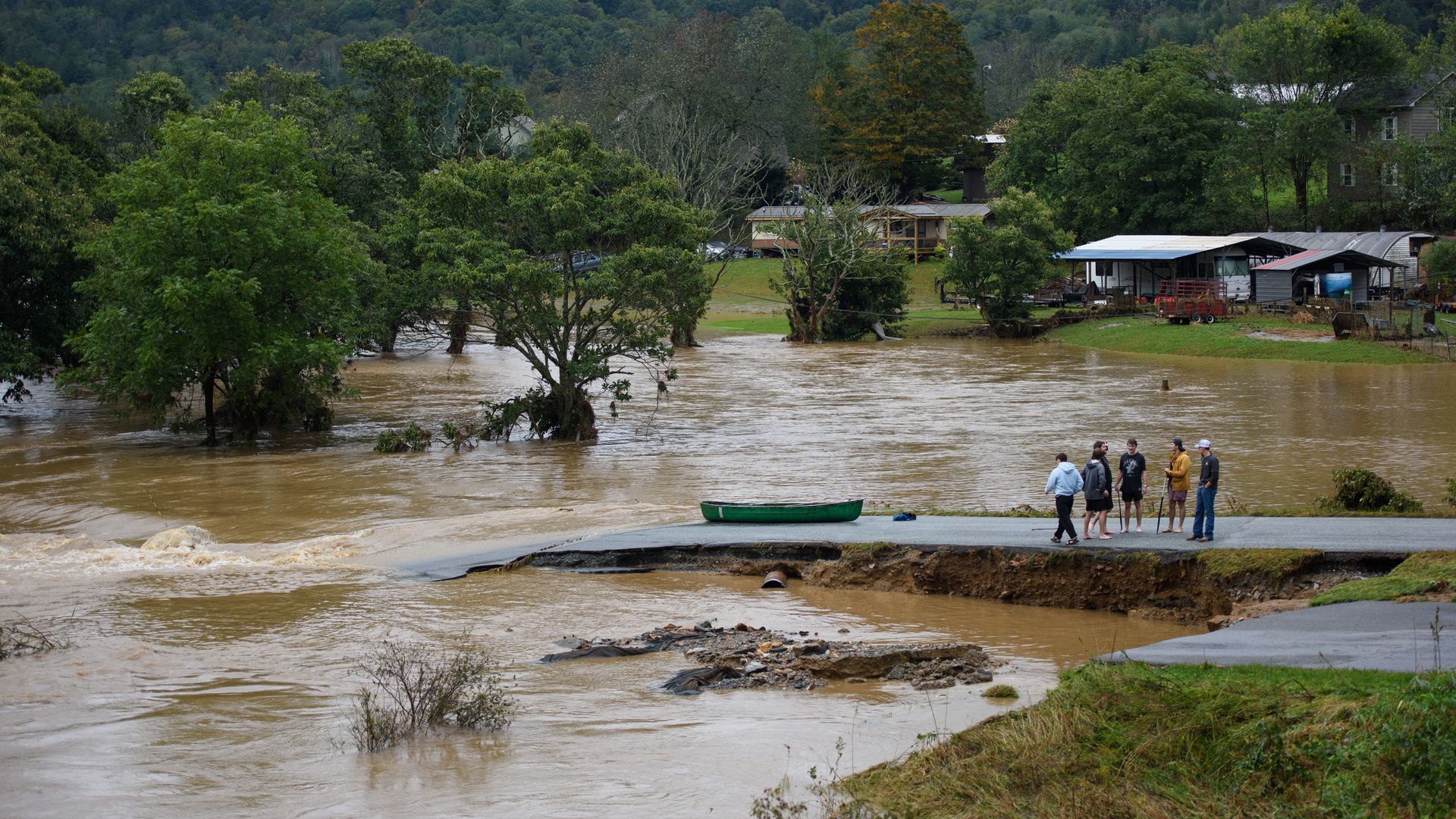
People talk at a washed out road along the South Fork New River in Boone, N.C. Photo: Melissa Sue Gerrits/Getty Images
Hurricane Helene is one of the most expansive and damaging hurricanes on record for the Southeast, due to its rare size, rapid intensification and rainfall.
The big picture: As of Saturday morning, at least 52 people across Florida, Georgia, the Carolinas and Virginia had died as a result of the massive storm, AP reports. About 3.7 million customers were without power in states including Florida, Georgia and the Carolinas, according to poweroutage.us.
- Helene's effects have extended across a wide area, causing record inland flooding in western North and South Carolina and unprecedented storm surge flooding in Tampa.
- The storm spared Atlanta from its strongest winds, but the center of the storm made it within 100 miles of the city as a hurricane, with the most damage occurring to the east-southeast of the city.
Zoom in: Now a post-tropical storm, Helene merged with another weather system to become a sprawling swirl of clouds centered over the middle of the country.
- Hurricane force wind gusts occurred in the southern Appalachians and cut power Friday night in parts of the Midwest, as the circulation around the storm wound down slowly.
- Historic flooding is underway in western North Carolina, South Carolina, southwestern Virginia and eastern Tennessee as heavy rains that preceded the storm combined with the hurricane's tropical rainfall.
The resulting landslides and river crests have become the new historical benchmark flood for the region.
- Interstates across western North Carolina "should be considered closed" Saturday due to flooding and landslides, North Carolina's transportation department stated on X.
The National Weather Service had warned the storm would be "one of the most significant weather events to happen in the western portions of the area in the modern era."
- This includes the Asheville, NC. area, where flooding of the Swannanoa River at Biltmore topped a previous all-time record by at least five feet. Peak rainfall totals in higher elevations reached 30.78 inches, per NWS.
- Asheville was cut off from communication and transportation links with the rest of the state on Saturday, and there are fears the death toll will increase once the floodwaters recede.
Hurricane Helene on Thursday evening became a ferocious Category 4 major hurricane, making landfall in the Big Bend region of Florida. It had started the day as a Category 1 storm.
- The National Hurricane Center accurately anticipated the rapid intensification and landfall location more than 24 hours in advance, which for meteorology was a major advance from just several years ago.
One stunning stat: With 140 mph maximum sustained winds, Helene was the strongest hurricane on record to make landfall in the Big Bend, where the peninsula curves into the panhandle.
- Images shared on social media showed a massive influx of storm surge, which reached at least 15 feet above ground level, inundating small communities such as Cedar Key, Fla.
Threat level: Flash flood emergencies — the most dire type of NWS flood alert — were issued Friday and again Saturday for portions of the Carolinas as rivers continued to flood.
- This storm has brought the highest number of flood emergency declarations the NWS has issued on a single day, with 23 on Friday alone.
At one point, a never-before-seen expansive set of at least a dozen flash flood emergencies went into effect for Asheville and surrounding areas in western North and South Carolina.
- "A historic rainfall event is underway for the southern Appalachians and vicinity with widespread/locally catastrophic flooding expected," a NWS Greenville-Spartanburg forecast discussion stated.
Context: Helene's intensification through landfall in the northern Gulf Coast is part of a trend tied in part to climate change.
- It puts Helene in the company of eight other landfalling storms in the U.S. that have rapidly intensified by at least 35 mph in 24 hours prior to landfall.
- Between 1982-2016 only six storms had displayed such a ramp up in intensity before a U.S. landfall.
Due to climate change, more storms now undergo rapid intensification, and there is an amplification of the intensification rates in the Atlantic Ocean Basin.
- Climate change is also causing hurricanes to produce more rainfall than they used to a few decades ago.
- Hurricane Helene tapped energy from the hottest waters in the already record hot Gulf of Mexico, known as the Loop Current. This is the same current of ultra-warm water that supercharged Hurricane Katrina in 2005.
The bottom line: Damage wrought by Hurricane Helene stretches across at least 10 states, and will continue to unfold through the weekend.
Go deeper: Tropical Storm Helene is catastrophic for western NC mountains
Hurricane Helene could rewrite storm history in the South
Editor's note: This story is developing and will be updated.
