Hurricane Helene could rewrite storm history in the South


Add Axios as your preferred source to
see more of our stories on Google.
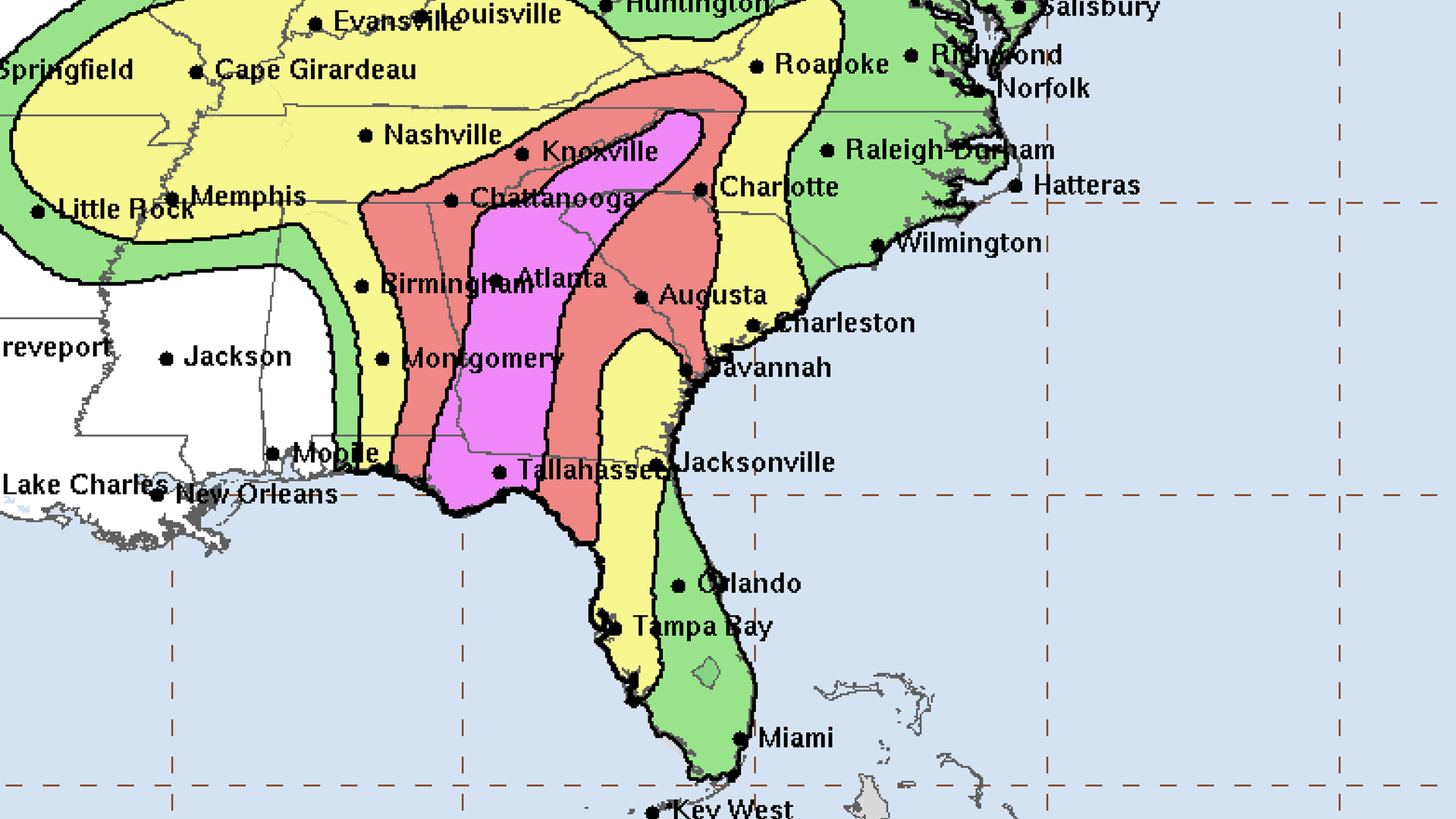
Map showing the flash flooding potential from Hurricane Helene as of Thursday afternoon. Pink represents a high risk of at least 70%, red represents moderate risk of at least 40%. Yellow and green are slight and marginal. Graphic: National Weather Service
Hurricane Helene threatened homes and lives throughout an unimaginably large triangle of the American South Thursday into Friday, from the southern tip of Florida, north to the South Carolina coast, and west to eastern Arkansas.
Why it matters: A direct hit for the Florida Gulf Coast. Potential hurricane-force winds in Atlanta. Tornado threats in Charleston, SC and Charlotte, NC. Historic rainfall and flooding for Asheville and other beloved Appalachian Mountain destinations. Flood watches through Nashville and all the way across the Mississippi River into Arkansas.
The latest: Helene made landfall in Florida's Big Bend region at 11:10pm Thursday as a Category 4 hurricane with maximum sustained winds of 140mph.
- After landfall, it was expected to speed up fast and zoom north toward Atlanta.
- The country's sixth-largest metro area, with more than 6 million residents, saw the NWS' hurricane warnings creep into its southern counties Thursday night, meaning hurricane conditions were expected. Helene figures to be one of the city's most significant encounters with a hurricane or tropical storm on record.
- Hundreds of thousands of people could lose power around Atlanta, given the combination of wind and rain.
Zoom out: The worst of the inland flooding, though, is forecast to occur even farther north, in the mountains where Georgia and Tennessee and North Carolina intersect, where some areas could see up to 15 inches of rain.
- Such rainfall amounts are likely to cause landslides and unprecedented flooding. Places around the French Broad and Swannanoa rivers in the Asheville area were already very high after storms Wednesday and Thursday, before the thrust of Helene arrived. Both rivers were expected to crest Friday afternoon at record levels, WLOS reported.
- "This will be one of the most significant weather events to happen in the western portions of the area in the modern era," the National Weather Service's Greenville-Spartanburg office warned in an urgent message Thursday.
- "Record flooding is forecasted and has been compared to the floods of 1916 in the Asheville area."
Flashback: The inland threats of Helene, particularly in Atlanta, had some forecasters using a loaded name as a comparison:
- "#Helene has the potential to be Atlanta's Hugo," Charlotte-based meteorologist Brad Panovich posted. "An inland hurricane [with] winds over a major metro similar to what happened in Charlotte in 1989."
- Hugo became one of the South's most memorable and despised storms, not just because of its catastrophic landfall as a Category 4 storm near Charleston, but also because it brought winds upward of 70 mph 200 miles inland to Charlotte, causing thousands of downed trees overnight.
- Before Hugo, another notorious storm had a name beginning with H: Hazel, in 1954, inundated southeastern North Carolina as a Category 4 storm on a full-moon high-tide, then raced north, resulting in 95 deaths in the United States and 100 more in Canada.
The bottom line: Every hurricane is a unique threat. Helene is one of the largest ever observed in the Gulf of Mexico, and it will move inland even faster than Hugo did, meaning its winds could carve a buzzsaw-like damage path through the forests and farmlands of Georgia and South Carolina, while unloading extraordinary rain upon the hills and rivers of North Carolina and Tennessee.
Editor's note: This breaking story was updated after Helene's landfall.
Go deeper: