Hurricane Hone slams Hawai'i with heavy rains in active Pacific storm season

Add Axios as your preferred source to
see more of our stories on Google.
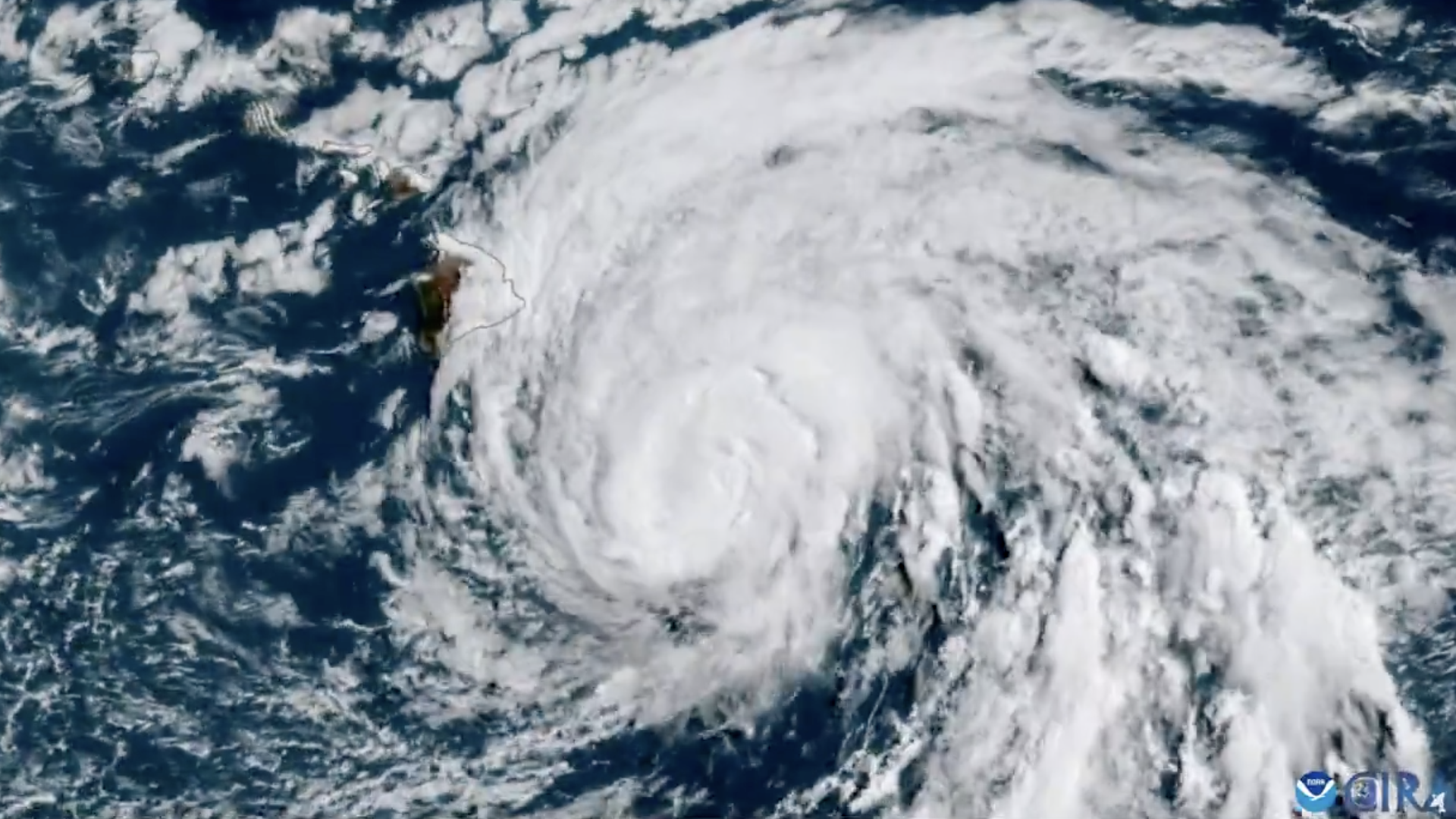
Hurricane Hone swirling near Hawai'i' over the weekend. Satellite image: CIRA/X
Hurricane Hone swept past Hawai'i over the weekend, lashing the Big Island with heavy rains as emergency officials said a high wind warning would remain in effect for several areas through 6am Monday local time.
The big picture: While the Atlantic hurricane season is experiencing a brief lull, parts of the Pacific are very active.
- The National Hurricane Center (NHC) has issued advisories for two hurricanes and one tropical storm and forecasters in Japan warned that a sixth typhoon to form this month was expected to threaten the nation as a "very powerful" storm this week, per the Japan Times.
Zoom in: Hurricane Hone reached its closest point to Hawai'i some 45 miles south-southwest of South Point, on Hawai'i's Big Island, on Sunday morning, according to the Central Pacific Hurricane Center in Honolulu.
- The Category 1 storm was packing maximum sustained winds of 80 mph some 160 miles from Honolulu as it continued to move away from the state late Sunday morning, per the NHC.
Threat level: The hurricane was bringing heavy rains "capable of causing flash flooding to the Big Island and causing strong winds areawide" throughout Sunday, the National Weather Service's Honolulu office noted in a forecast discussion.
- A hurricane warning was issued for the waters south of the Big Island and a tropical storm warning was in effect for all other waters surrounding Big Island. A flash flood warning was in effect for much of the island's coast.
- "Wind and heavy rainfall will gradually diminish by late tonight into Monday," the NWS Honolulu said.
Zoom out: In addition to Hurricane Hone, the NHC issued advisories for the newly formed Tropical Storm Hector and the weakening Category 3 Hurricane Gilma. Neither of these storms posed any immediate threats to land.
- Meanwhile in Japan, forecasters warned that Typhoon Shanshan would strengthen on Tuesday ahead of approaching near western and eastern Japan, where it could dump heavy rains and powerful winds.
- The typhoon that originated near the Mariana Islands, northwestern Micronesia, on Aug. 22 could bring maximum sustained winds of up to 110 mph Tuesday near parts of Kyushu, the southwesternmost of Japan's main islands.
- The storm was forecast to weaken on landfall in Honshu or Shikoku by Wednesday morning.
Between the lines: Sea surface temperatures were at record levels for 15 months until July and continue to be above-average in many places, a situation linked to a spike in global warming during 2023 and into 2024.
- In addition to disrupting marine ecosystems, including through coral bleaching, warmer oceans provide more energy for hurricanes to develop and intensify, Axios' senior climate reporter Andrew Freedman notes.
- In the ocean around Hawai'i, climate change made the ocean temperature at this location on this day at least twice more likely, per Climate Central's Climate Shift Index: Ocean, which aims to show the influence of climate change throughout the world's oceans in real time.
- Climate change made the Pacific Ocean temperature off Japan's Shikoku coast at least 100 times more likely, per the Climate Central index.
State of play: Meteorologists are still expecting an extremely active hurricane season in the Atlantic.
- The region has already seen five named storms — including Hurricanes Beryl and Debby, which made landfall in the U.S.
Go deeper: Tracking the 2024 hurricane season
