Axios Generate

September 29, 2022
๐ Hi readers! Today's newsletter has a Smart Brevity count of 1,228 words, 5 minutes. Let's get to it...
1 big thing: How climate change made Ian worse just before landfall

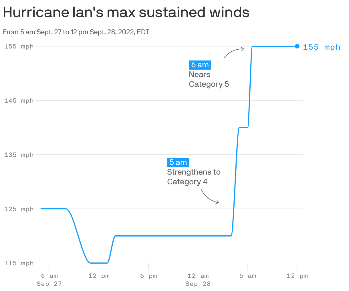
Hurricane forecasters' worst nightmare came true yesterday morning when what had been a Category 3 storm the night before suddenly jumped almost to Category 5, Andrew writes.
Why it matters: It used to be rare for storms to keep strengthening until landfall, let alone do so rapidly. Now it is not โ and studies show this is a dangerous sign of climate change.
The big picture: Ian's intensity leap was made possible by warm ocean temperatures and abundant atmospheric moisture โ both factors that climate change enhances.
- In recent years, multiple storms have rapidly intensified as they neared the Gulf Coast and kept getting stronger through landfall.
- Previously, tropical storms and hurricanes tended to weaken as they neared the northern Gulf Coast in particular.
- But that didn't happen with Hurricanes Laura or Ida in 2020 and 2021 โ or with Hurricane Michael, which ramped up to a Category 5 storm in the Florida Panhandle in 2018.
It's not just the U.S. suffering the consequences of rapidly intensifying tropical cyclones. Consider an example from halfway around the world, which occurred just as Ian was spinning up in the Caribbean.
- In the western tropical Pacific Ocean, a storm named Noru began swirling toward the Philippines.
- It surprised forecasters by suddenly strengthening from a robust tropical storm to a Category 5 super typhoon with 160 mph winds in just 24 hours.
- This was one of the fastest rates of intensification on record, anywhere.
Threat level: Rapid intensification shortly before landfall can take people off guard and strand them in vulnerable spots for storm surge flooding, damaging winds, or both.
- Emergency management officials design evacuation plans based on storm intensity and movement. Sudden shifts can render such planning inadequate.
- All landfalling storms now contain more dangerous coastal flooding in their arsenals, due to human-caused sea level rise.
What we're watching: Intensity forecasts have been stuck, even as forecasters have made great strides in predicting storm tracks several days in advance.
But there's research underway to better predict intensity shifts, using new technologies such as Saildrones, satellites and other sensors.
The bottom line: Until we crack the code of how to tell that a storm will leap through categories just before landfall, with enough lead time to act, we are going to be vulnerable to more devastating, and potentially deadly, surprises.
2. ๐ The devastating storm by the numbers
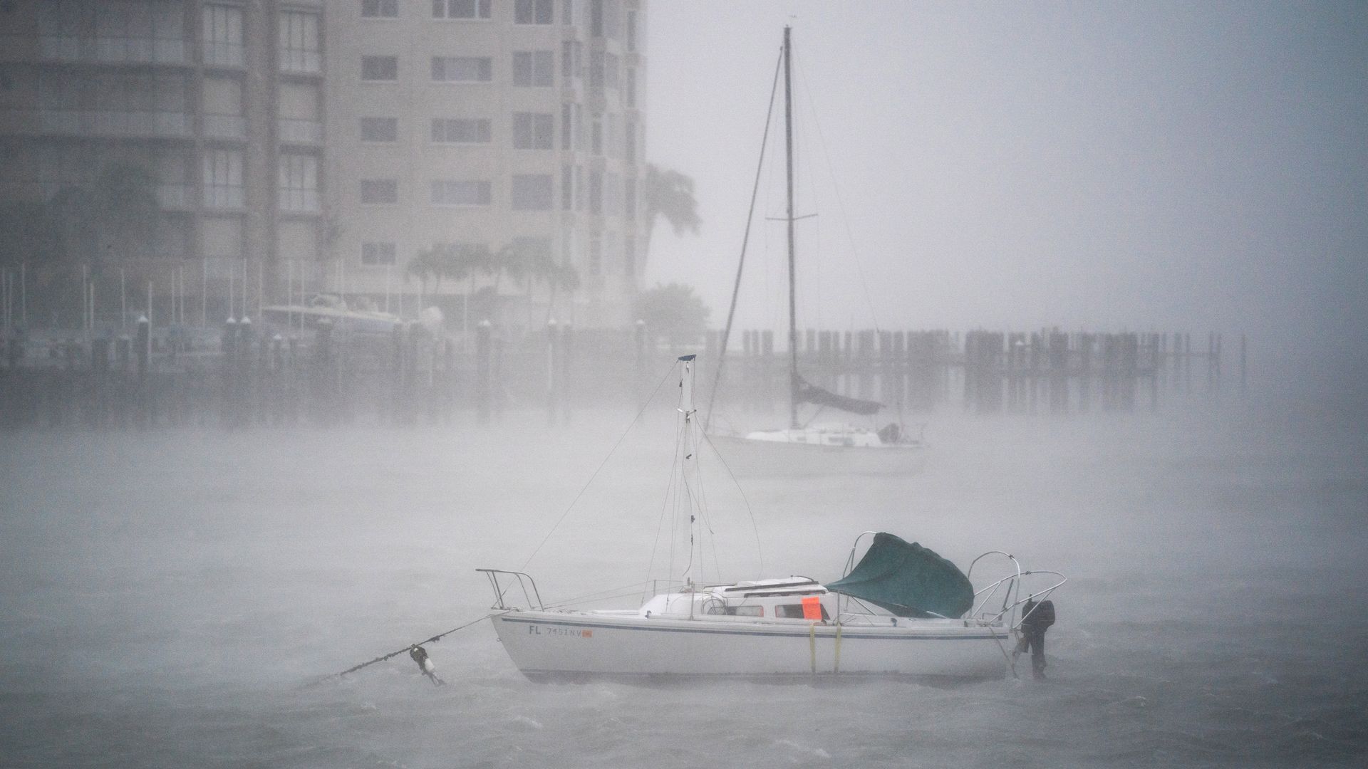
Wind gusts blow in Sarasota Bay as Hurricane Ian churned to the south on Sept. 28 in Sarasota, Florida. Photo: Sean Rayford/Getty Images
Hurricane Ian came ashore as one of the most powerful hurricanes to strike the U.S., tied for 5th on the list based on its maximum sustained winds of 150 mph.
- It is also the sixth Category 4 or 5 storm to strike the Gulf Coast in the past seven years.
The wind:
- 150 mph: Maximum sustained winds at landfall, making it tied for the 4th strongest storm by wind speed to strike Florida.
- 140 mph: Cape Coral, Fla.
- 124 mph: Punta Gorda, Fla.
- 112 mph: Pelican Bay, Fla.
The storm surge
- 7.2 feet: Record high storm surge in Fort Myers
- 6.18 feet: Record high storm surge in Naples
The power outages
2.54 million: Customers without power in Florida as of 7am ET today.
The rainfall
- 14.42 inches: Rainfall total in Lehigh Acres, Fla.
- 12 to 20 inches: Radar estimates of total rainfall in Central Florida, with 10 to 15 inches falling in northeastern areas.
3. When hurricane prep is out of reach
Illustration: Sarah Grillo/Axios
As Hurricane Ian approached Florida, Tampa's lower-income households lacked the funds to stock up on storm supplies โ and rising prices added to that pressure, Axios' Ayurella Horn-Muller reports.
Driving the news: Millions of Floridians spent the past few days evacuating or gearing up for the storm.
But preparation ahead of a hurricane is an added stressor for the 42% of Hillsborough Countyโs population โ and the 46% of neighboring Pinellas County โ that canโt afford basic living costs.
The big picture: Inflation has driven up grocery prices. Food costs have increased 11.4% over the last year โ the largest annual spike since 1979 โ per USDA's Economic Research Service.
- Thomas Mantz, CEO of the nonprofit Feeding Tampa Bay, says this compounds COVID-19's effect on food insecurity in the Florida region.
- That's adding pressure to the nonprofit's bulk purchasing and disproportionately impacting communities of color.
- Now hurricane preparation calls for added investment. The Tampa Bay Times reports that Florida officials advise stocking up one weekโs worth of nonperishable food and water per person, as well as pets.
- "Families don't have the resources to put food in their own pantries, keep things stocked up because it's just too expensive," Mantz told Axios.
Threat level: Food and water are only one piece of the preparedness picture.
- Hurricane kits also commonly include wood to board up homes, generators, and much more.
- Preparing for a major storm can cost thousands of dollars. Evacuations are even more costly.
4. ๐๐ฝโโ๏ธCatch up fast on the Nord Stream leaks
European officials are moving to protect oil-and-gas infrastructure against potential attacks even as experts assess the environmental toll of still-mysterious leaks in the Nord Stream gas pipelines, Ben writes.
Driving the news: The Russia-to-Germany pipelines in the Baltic Sea are leaking the powerful greenhouse gas methane after damage this week that EU and U.S. officials believe was sabotage.
- A fourth leak has been reported off southern Sweden.
- Neither pipeline was in operation but still contained volumes of gas.
Zoom in: A few developments are on our radar...
- "Norway will deploy its military to protect its oil and gas installations against possible sabotage after several countries said two Russian pipelines to Europe spewing gas into the Baltic had been attacked," Reuters reports.
- Politico reports on early estimates of methane volumes spewing into the atmosphere. The head of Denmark's energy agency "told reporters...that the leaks would equate to about 14 million tons of CO2, about 32 percent of Denmark's annual emissions."
- The piece also puts the leaks in context. It notes Lauri Myllyvirta of Centre for Research on Energy and Clean Air believes the leaks are comparable to how much escapes from Russia's oil-and-gas infrastructure in a given week.
What we don't know: While there's plenty of suspicion about Russian sabotage, the source of the reported explosions remains unclear.
5. Oil companies size up the climate law

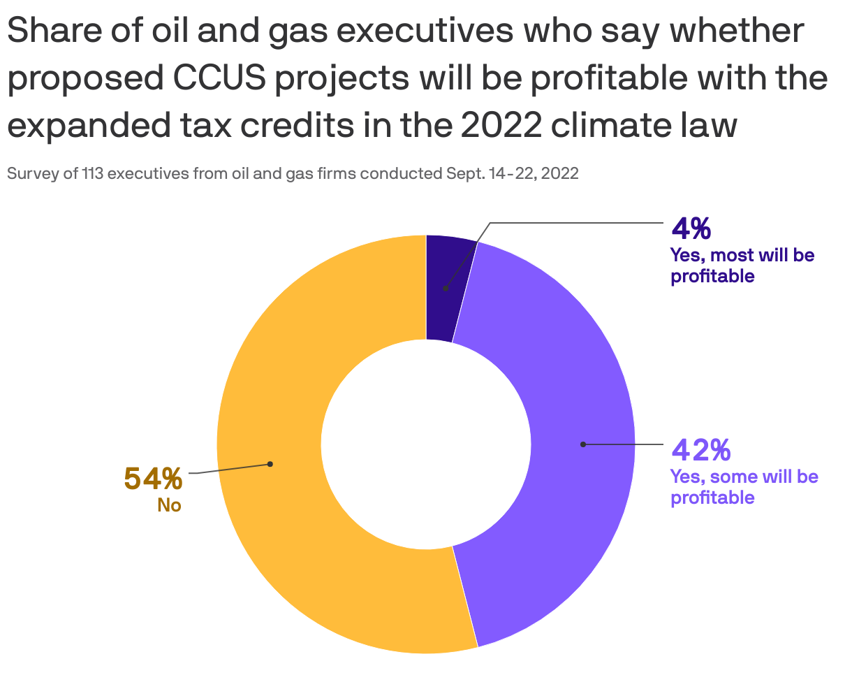
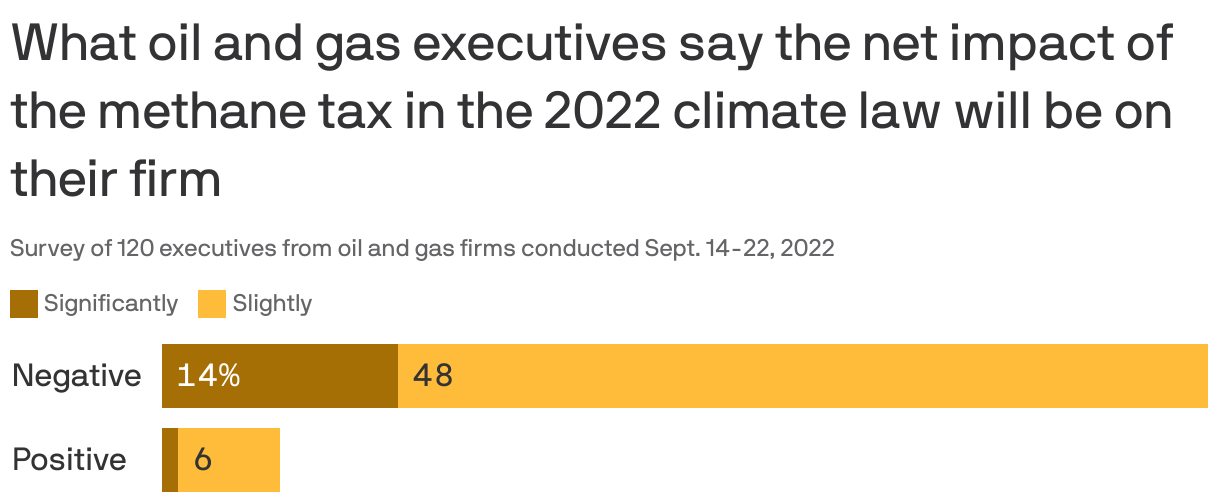
A sizable chunk of oil-and-gas executives don't see carbon capture projects becoming profitable despite expanded tax credits in the new climate law, per the latest Dallas Fed survey, Ben writes.
Why it matters: It provides an initial look at how a wide range of companies in the heart of the U.S. oil patch see the newly enacted policies.
The same quarterly poll also sizes up their take on the law's fee on some methane emissions, with a majority seeing a negative impact on their firm.

The big picture: The quarterly report more broadly explores the state of the sector in a region that includes the prolific Permian basin and other major producing areas.
It finds...
- The sector's "business activity index" remains robust but came in lower than Q2. In addition, supply chain delays persist, which is one reason why U.S. output growth is very slow despite attractive prices.
- Speaking of prices, the survey average shows expected U.S. oil prices in the high $ 80s per barrel at year-end, far lower than the Q2 poll.
6. ๐ค Quoted
"I think that most people who are in the venture capital space don't actually understand how infrastructure finance works."โ Jigar Shah, head of the Energy Department's loan programs office
That's part of Shah's wide-ranging interview with Axios Pro Climate Deals' Alan Neuhauser. Sign up
๐ฌ Did a friend send you this newsletter? Welcome, please sign up.
๐Thanks to Mickey Meece and David Nather for edits to today's newsletter. We'll see you back here tomorrow!
Sign up for Axios Generate

Untangle the energy industryโs biggest news stories

