San Francisco is sinking, and it's worse than we thought


Add Axios as your preferred source to
see more of our stories on Google.
San Francisco is sinking, and new research shows it's more widespread — and riskier — than was once suspected.
Why it matters: Land subsidence is an invisible but growing threat to urban infrastructure — cracking roads, destabilizing buildings and making low-lying areas even more flood-prone.
- In San Francisco, it combines with sea level rise, seismic instability and aging buildings and infrastructure to heighten long-term risk.
Driving the news: In a new peer-reviewed study published in Nature, researchers analyzed six years of satellite radar data in the 28 most-populous U.S. cities.
- They found that 25 are subsiding, affecting more than 33 million people — over 10% of the U.S. population — who live on sinking land.
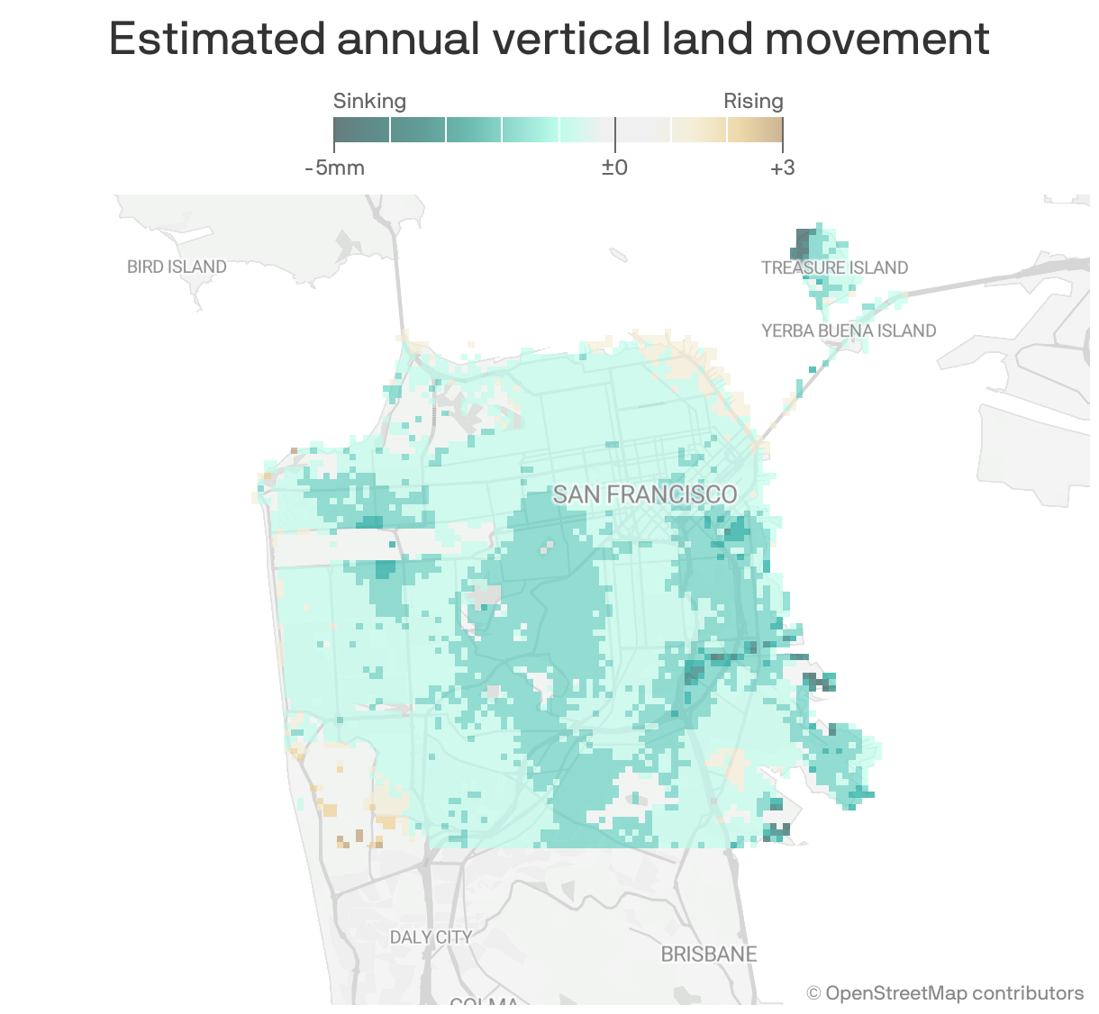
Zoom in: Over 92% of San Francisco's land area is sinking at measurable rates, and some faster than others, per the study.
- SF is sinking by almost 1 millimeter (0.04 inches) on average per year, though that figure reaches as high as 10 millimeters (0.4 inches) for some neighborhoods.
- Tectonic activity and sediment compaction appear to be the dominant drivers in San Francisco — not groundwater pumping, which is a primary culprit elsewhere — the study notes.
- Parts of the region built on landfill — such as Treasure Island, SoMa, the eastern bayshore and San Francisco International Airport — are seeing the highest rates of subsidence.
The big picture: Subsidence has long been associated with sinking cities such as Jakarta, Indonesia; New Orleans and Houston — the fastest-sinking of the 28 studied — but new research shows it's a widespread issue across the U.S.
- Whereas natural processes influence urban land subsidence in the United States, most of the sinking land results from human-driven activities, with 80% of the subsidence associated with groundwater withdrawals.
What they're saying: The researchers behind the study are urging cities to factor subsidence into zoning, infrastructure upgrades and flood planning.
- They're also calling for long-term ground monitoring and public outreach to ensure communities are prepared for slow but damaging shifts.
- Uneven sinking puts stress on buildings, leading to cracks, warped frames or even structural failure, researcher Manoochehr Shirzaei told New Scientist.
- "We need to start treating subsidence like the slow-moving disaster it is."
State of play: San Francisco, like other Bay Area cities, has worked in recent years to counter land instability and shore up the waterfront.
- Planned actions include bolstering critical infrastructure and implementing land use controls in areas like Bayview-Hunter's Point, which served as a dumping ground for toxic waste for years and is highly vulnerable to sea level rise.
- The city already requires protections against flood damage for new construction and significant renovations to buildings in designated flood hazard areas.
Stunning stat: By 2050, sea levels in low-lying parts of the Bay could rise by as much as 17 inches compared with 2000 levels, per a February NASA report.
Worthy of your time: Homeowners, renters and businesses in San Francisco are eligible for federally subsidized flood insurance through the city's participation in the National Flood Insurance Program.
What to watch: The San Francisco Bay Conservation & Development Commission adopted a regional shoreline adaptation plan last December aimed at guiding local governments in their efforts to address rising sea levels.
- California law requires all cities and counties along the coast and bayshore to submit a subregional plan by 2034.
Editor's note: This story has been corrected to show 1 millimeter is equivalent to 0.04 inches (not 0.4).