Arctic blast to plunge New Orleans below freezing


Add Axios as your preferred source to
see more of our stories on Google.


New Orleans is forecast to go from 70-degree weather to below freezing this weekend, thanks to a massive winter storm that's expected to dump snow and ice elsewhere in the Deep South.
Why it matters: Residents should prepare for freezing nights and possible pipe damage — even though the worst of it will be north of New Orleans.
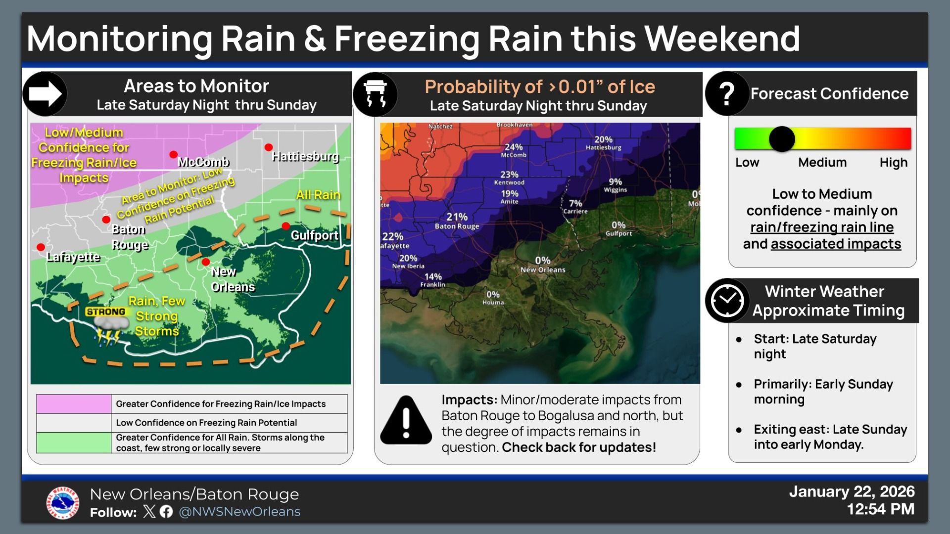
The big picture: The National Weather Service says icy roads are unlikely in New Orleans and the North Shore as of Thursday's forecast.
- New Orleans is expected to be rainy and in the high 60s through Sunday.
- However, freezing rain and icy roads are possible in Baton Rouge late Saturday through Sunday afternoon. Parts of central and north Louisiana are under a winter storm watch.
- Forecasters say they'll get more clarity Friday on how far south the ice is expected.
Zoom in: Gov. Jeff Landry issued a state of emergency Thursday in advance of the ice storm, saying "significant" impacts are expected primarily in central and north Louisiana.
- Power outages are a major concern. He said he's already getting reports of gas shortages in north Louisiana.
- Officials are opening warming centers and urging residents to find a safe place and stay there.
- "Stay off the roads," Landry said during a press conference Thursday. "Get comfortable. Cook a gumbo."
What's happening: The arctic blast will reach New Orleans late Sunday, NWS says, bringing the coldest air of winter.
- Daytime temps will drop more than 30 degrees in 24 hours. New Orleans will be below freezing Sunday and Monday nights. Full forecast.
- Residents should protect people, pets, pipes and plants.
Threat level: DOTD is preparing to salt bridges and overpasses if needed, spokesperson Daniel Gitlin says.
- Crews will prioritize Interstate 10, U.S. 90, Airline Highway and Clearview Parkway, among others, Gitlin says.
- After last year's historic snowstorm, DOTD bought new equipment to better handle ice and snow. The agency now has more capabilities to pre-treat overpasses with salt brine.
- See real-time road conditions in Louisiana.
Meanwhile, Entergy says it won't disconnect any overdue customers in Louisiana through at least Monday.
- Plus, the utility company has crews prepared to respond to outages if needed.
State of play: Driving and flying will be a mess across most of the South and East Coast this weekend.
- Some of the latest model runs are calling for over a foot of snow in parts of Texas, Tennessee, Georgia and elsewhere.
- Ice will be a major threat too, likely causing power outages and downed trees.
- Nearly 148 million Americans are facing winter storm watches spanning from New Mexico to Maine as of Thursday afternoon.
The intrigue: NWS director Ken Graham tells Axios the agency is putting every available resource into forecasting for the storm — including using "hurricane hunter" aircraft.
- "It is a complicated, tricky forecast, so we're really trying to refine it the best we can," Graham says.
- Hurricane hunters from NOAA and the U.S. Air Force are flying over both the Pacific and the Gulf to collect useful intel for predicting this far-reaching storm — a rare multifront effort. Go deeper.