New New Orleans flood sensors will deliver real-time data

Add Axios as your preferred source to
see more of our stories on Google.

New Orleans' new flooding sensors can deliver real-time water level data. Photo: Courtesy of United Way of Southeast Louisiana
New sensors being installed across New Orleans will soon deliver real-time flooding data to city officials.
Why it matters: The data can plug into first responders' maps, which would better inform them of blocked roadways during emergencies, and it might one day be accessible to residents through Google Maps, the founder of the tech company behind the project says.
The big picture: Flooding in New Orleans is commonplace as the city continues to sink, infrastructure maintenance is woefully behind and human-created climate change powers stronger and faster downpours, even outside hurricane season.
- But right now, the best system we have for identifying when water is starting to rise on city streets is by people seeing and reporting it.
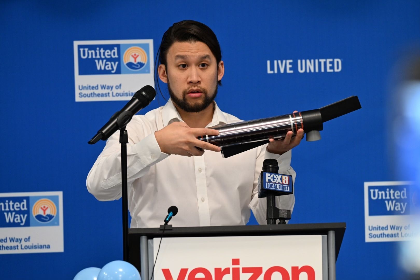
Zoom in: Brandon Wong, the CEO of tech company Hyfi, says he can change that with new flooding sensors, which a press release says can be installed "anywhere."
- In a July 18 press conference introducing the United Way-led and Verizon-sponsored project, Wong showed off one of the sensors his company created.
- Holding a black tube about the length and width of a grown person's arm, Wong showed how easily it can be replaced if something should break down the road, using one hand to remove and replace the whole system.
- The devices are solar-powered and use ultrasonic sensors to identify whether there's any water below them, and if so, how far above the ground it's risen. They then communicate that information across a wireless cellular network to Hyfi's platform "where it renders a dynamic, real-time map" of flood conditions, a press release says.
By the numbers: The map data will be shared with emergency preparedness officials once the first phase of installation, which includes more than 20 of the sensors across New Orleans, is complete.
- In the program's first year, Verizon is covering the cost of installation, maintenance and repairs, but then the $1,500 ongoing monitoring cost would have to be covered by the city, Wong says.
- Wong's goal is to show in the first 12 months that the data is valuable enough to keep paying for, he says.
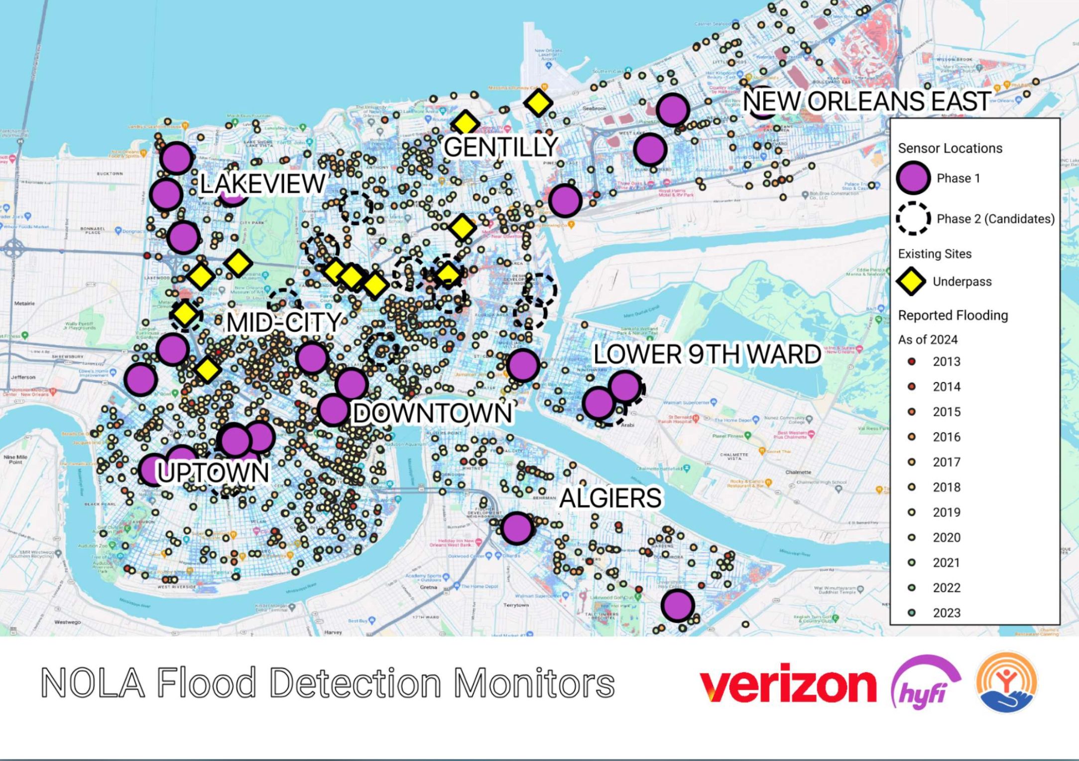
Yes, but: The sensors can only identify what's happening in the space below them, which still leaves most of New Orleans unmonitored.
- City officials, including those at the Sewerage and Water Board, were involved in conversations deciding where the first sensors should go, and they considered things like traffic patterns, long-term planning and "where the gaps in our coverage" already are, says Austin Feldbaum with the New Orleans Office of Homeland Security and Emergency Preparedness.
What they're saying: The map data might be able to help the city "get to a place where we're not flooding in certain areas," said NOHSEP director Collin Arnold. "It's a tall order."
- "We have challenges, street by street in some cases," he said. "And our challenge has been, what type of device … can we put in, that is going to be right down to the granular street level [to provide real-time information]? And this is that product."
Between the lines: The New Orleans installation is a pilot project for Hyfi.
- Wong says the company's focus is on sales to municipalities, but Hyfi would be open to individual sales if, for example, a homeowner wanted to know the status of flooding at their own property.
What's next: The sensors have a year to prove their worth to New Orleans officials.