Des Moines braces for severe winds and possible tornadoes


Add Axios as your preferred source to
see more of our stories on Google.
A rare and intensifying storm is threatening to bring record warmth, strong wind gusts of up to 80 mph and possible tornadoes across Iowa in the late afternoon and early evening.
Why it matters: Any tornadoes that form may be fast-moving and difficult to warn about in advance, Axios' Andrew Freedman reports.
- "Storms could move through a typical Iowa county in only 20 minutes," the National Weather Service in Des Moines said in an online briefing.
- Any fires could spread quickly, while damage to trees and power lines and power outages are expected, per NWS.
State of play: Storms are forecast to move from west to east across central Iowa from 4pm to 8pm Wednesday.
- Temperatures, which have reached the upper 70s in some areas and already broke the state's high record for December, will plummet into the 20s and 30s at night.
- The peak of the storm is expected to hit the Des Moines metro near Interstate 35 around 6pm, WOI-TV reports.
Yes, but: Keep an eye out, as the storm could quickly change.
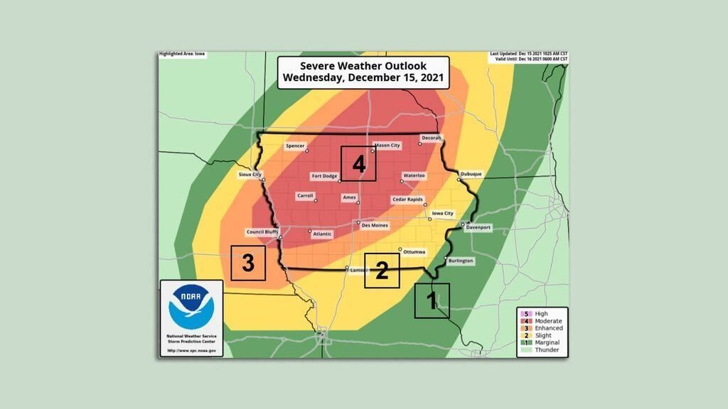
Of note: NWS increased Des Moines' severe weather outlook from "enhanced" to "moderate" — the second-highest ranking on the risk scale — Wednesday morning.
- It's the first time NWS has issued a "moderate" risk severe weather warning in the Iowa, Minnesota and Wisconsin region during the month of December.
The big picture: The hazardous weather threat for Iowa in December is unprecedented.
- By the end of the day, temperatures throughout the state will be close to 40 degrees above average for this time of year.
What they're saying: NWS warned on Twitter on Wednesday the impact of the high winds could be similar to the derecho that devastated the state and left damage across the Midwest in August of 2020, killing four people.
- "The strong winds today will be widespread and over a longer duration," NWS tweeted.