Franklin Co. would get split districts under new congressional map

Add Axios as your preferred source to
see more of our stories on Google.
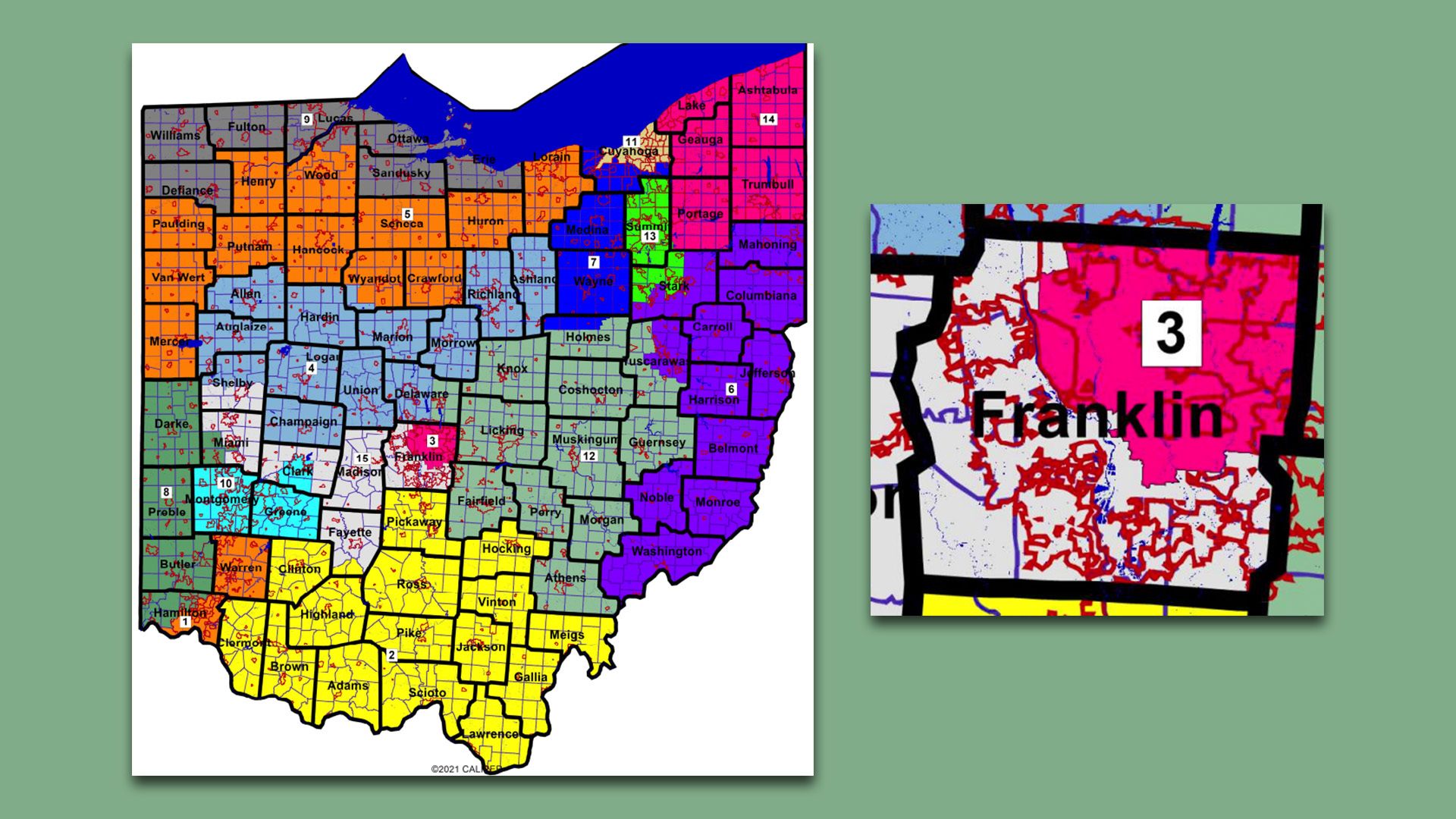
The new congressional district map approved on Wednesday, and a close-up view of Franklin County. Map courtesy the Ohio Redistricting Commission.
Franklin County could be split into two congressional districts — one Republican-leaning and one Democratic-leaning — under a new map approved yesterday by the Ohio Redistricting Commission.
State of play: Like the previous iterations, this map needs the blessing of the Ohio Supreme Court to become official.
- Should the court approve this map, it likely would be in play for just the 2022 and 2024 election cycles after failing to achieve the required bipartisan approval from the seven members of the Ohio Redistricting Commission.
Zoom in: The northeast quadrant of Franklin County would make up the newly drawn 3rd District, with Columbus Democrat Joyce Beatty as the incumbent.
- Democratic voters would outnumber Republicans more than two-to-one, per analysis from Dave's Redistricting.
- It would include the Columbus neighborhoods of Clintonville, Linden, Easton and the Ohio State campus.
- Other communities include Upper Arlington, Bexley, Worthington, Westerville, Whitehall, New Albany, Gahanna and Reynoldsburg.
The intrigue: The remaining part of Franklin County would be in District 15 alongside all or parts of five other counties, with Columbus Republican Mike Carey as the incumbent.
- The district would lean moderately red, per Dave's Redistricting, by a 9% margin.
- It would include the Columbus neighborhoods of Hilltop, Franklinton and much of the south side.
- Other communities include Hilliard, Dublin, Grove City, Groveport, Canal Winchester and Obetz.
Meanwhile, areas like downtown Columbus, the Arena District, German Village and the Short North would be split among the two districts.
Between the lines: This map is likely to garner scrutiny from Ohio Supreme Court justices that already rejected an earlier redistricting attempt for gerrymandering.
- In its January ruling, the Court's majority specifically dinged GOP mapmakers for packing Franklin County Democrats into a heavily blue district so that Republicans could control another.
- This 1-1 split contrasts with Franklin County voting for President Biden by a 65-34% margin in 2020.
Yes, but: Districts are required to be equal in population. That comes out to around 787,000 constituents apiece.
- Franklin County has an estimated 1.32 million residents, meaning there is bound to be a local congressional district that includes at least one other county.
- Every other surrounding county voted for former President Trump in 2020.
Still, the court has raised an eyebrow at Franklin County being paired with rural, Trump-dominated areas instead of with neighboring Delaware County — which is closer to being an even political split.
- It's possible the court will do so again.
What they're saying: That could spell bad news for Republican mapmakers, according to redistricting expert Dave Wasserman with the Cook Political Report.
What's next: The court has to determine if this map and a separate pair of state legislative maps approved last week are constitutional.
- If so, they're set and ready for voters.
- If not, it's once more unto the breach, dear friends.