La Niña could make Texas drier


Add Axios as your preferred source to
see more of our stories on Google.
Our rainy interlude could be winding down, with the National Oceanic and Atmospheric Administration (NOAA) issuing a La Niña watch, indicating that the current strong El Niño may be headed for the exits.
Why it matters: The scorching 2011 drought that led to devastating wildfires in Bastrop County and record drops in Central Texas' water supply coincided with a La Niña.
- That year, then-Gov. Rick Perry designated several official days of prayer for rain.
- As the drought stretched into 2012, city officials ordered Austin restaurants not to serve drinking water unless it was specifically requested.
Meanwhile: We're still recovering from the pounding heat and dry conditions of last summer.
- Currently lakes Travis and Buchanan, the chief reservoirs of Central Texas, are 42% full, according to the LCRA.
- Much of Travis, Williamson and Hays counties, and the Hill Country, are experiencing drought conditions.
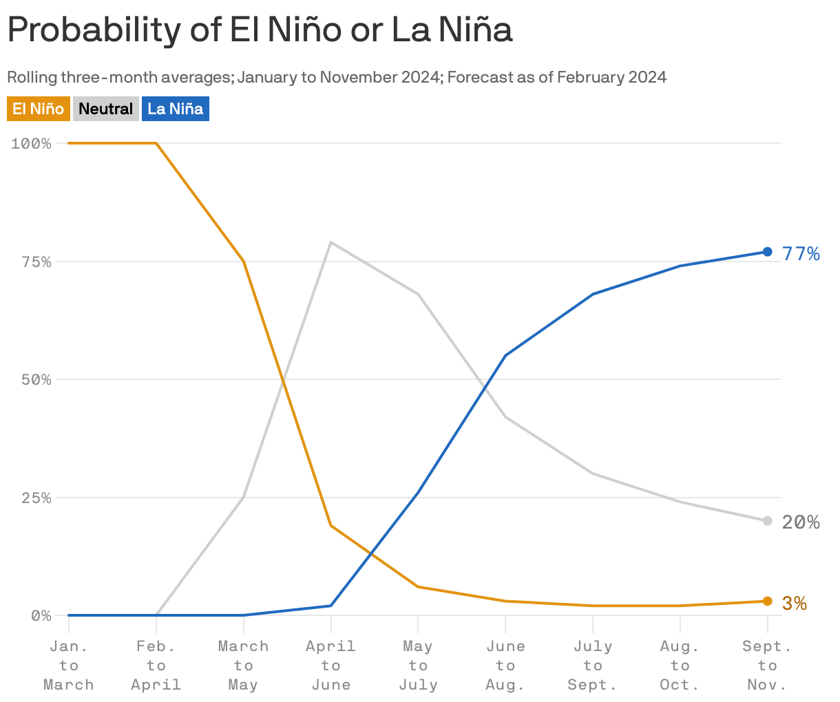
Zoom in: The El Niño still underway features milder-than-average ocean waters in the tropical Pacific and associated shifts in the atmosphere. There are increasing signs that a transition is afoot.
- A "watch" means that conditions are favorable for the development of La Niña within the next six months.
- In its new forecast discussion, NOAA estimates that by the fall there's a 77% chance of a La Niña developing.
Between the lines: La Niña conditions tend to favor drought along the southern tier of the Lower 48 states.
What they're saying: Meteorologists with the National Weather Service office covering Austin say La Niña drives up the "likelihood of returning to drier, warmer-than-normal conditions in late 2024."
- "In Texas, La Niña can be tough on us," Chris Suchan, the chief meteorologist at San Antonio NBC affiliate WOAI, wrote on X. "Need to make the most of El Nino next 3 - 5 months before it fades."
The big picture: The added ocean heat and its release to the atmosphere associated with El Niño has provided an extra boost to global average temperatures, on top of the human-caused global warming trend.
- This extra warming helped 2023 become the hottest year on record.
- La Niña features below-average sea surface temperatures in the tropical equatorial Pacific Ocean and tends to cool global average temperatures slightly.