Record winter warmth smashes highs in D.C., Southeast


Add Axios as your preferred source to
see more of our stories on Google.
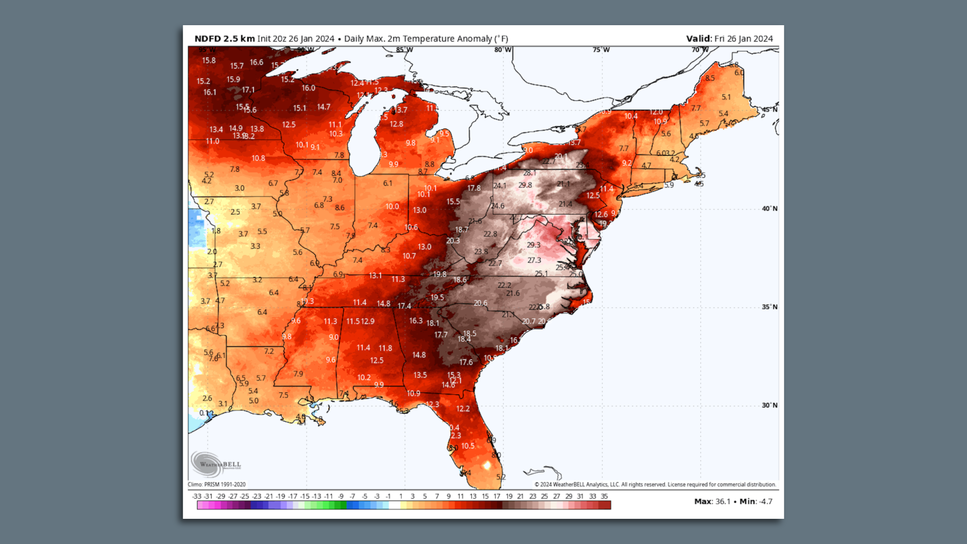
Map of temperature anomalies on Jan. 26 across the eastern U.S. Image: Weatherbell.com
A January thaw for the record books is firmly established across much of North America, with Washington, D.C., setting an all-time January high temperature record of 80°F Friday, as similar milestones fell elsewhere.
Why it matters: The record warmth is by far the earliest 80-degree temperature D.C. had ever seen, coming weeks before the previous 80-degree high and just one week after snow blanketed the nation's capital.
- In an average year, the city doesn't see 80-degree temperatures until around March 28, per the Washington Post's Capital Weather Gang.
- In many locations in the U.S., the winter is the fastest warming season, with record-breaking thaws happening more frequently.
By the numbers: Reagan National Airport, the observing site for the city, reached 80 degrees around 2pm ET, breaking the previous monthly record of 79°F, set on Jan. 26, 1950.
- The previous earliest 80-degree temperature in Washington came on Feb. 21 in 2018.
- Washington's Dulles International Airport had peaked at 79°F around 2 pm on Friday.
- Charleston, S.C. had reached 83°F Friday afternoon, tying the city's monthly record for January.
- Wilmington, N.C. beat its all-time January record as well, with a preliminary high of 83°F Friday.
The big picture: Cold air has been in short supply this winter in parts of the country, particularly the Mid-Atlantic and Southeast. A cold spell during early to mid-January has given way to a thaw projected to last into February, as a relatively mild Pacific flow of air dominates weather patterns.
- The record warmth on Friday resulted from a low pressure area moving to the west of the Appalachians, as a warm front pushed north, past Washington and Baltimore.
- But zooming out, much of North America is experiencing milder-than-average conditions right now, with temperatures of 20-35°F above average in Canada, and pulses of mild air pushing across the U.S.
Between the lines: According to a recent analysis from Climate Central, cold spells are moderating quickly across the U.S. due to human-caused global warming.
- Since 1970, the coldest day of the year has warmed by an average of 7°F across 242 locations the climate research and communications group analyzed.
- The areas that have seen coldest days moderate the most are the Ohio Valley and Northwest.
- Researchers also found that while extreme cold events are still occurring in a warming world, they are becoming less frequent and milder nationwide.
