U.S. East Coast faces "life-threatening" wave threats from Hurricane Erin

Add Axios as your preferred source to
see more of our stories on Google.
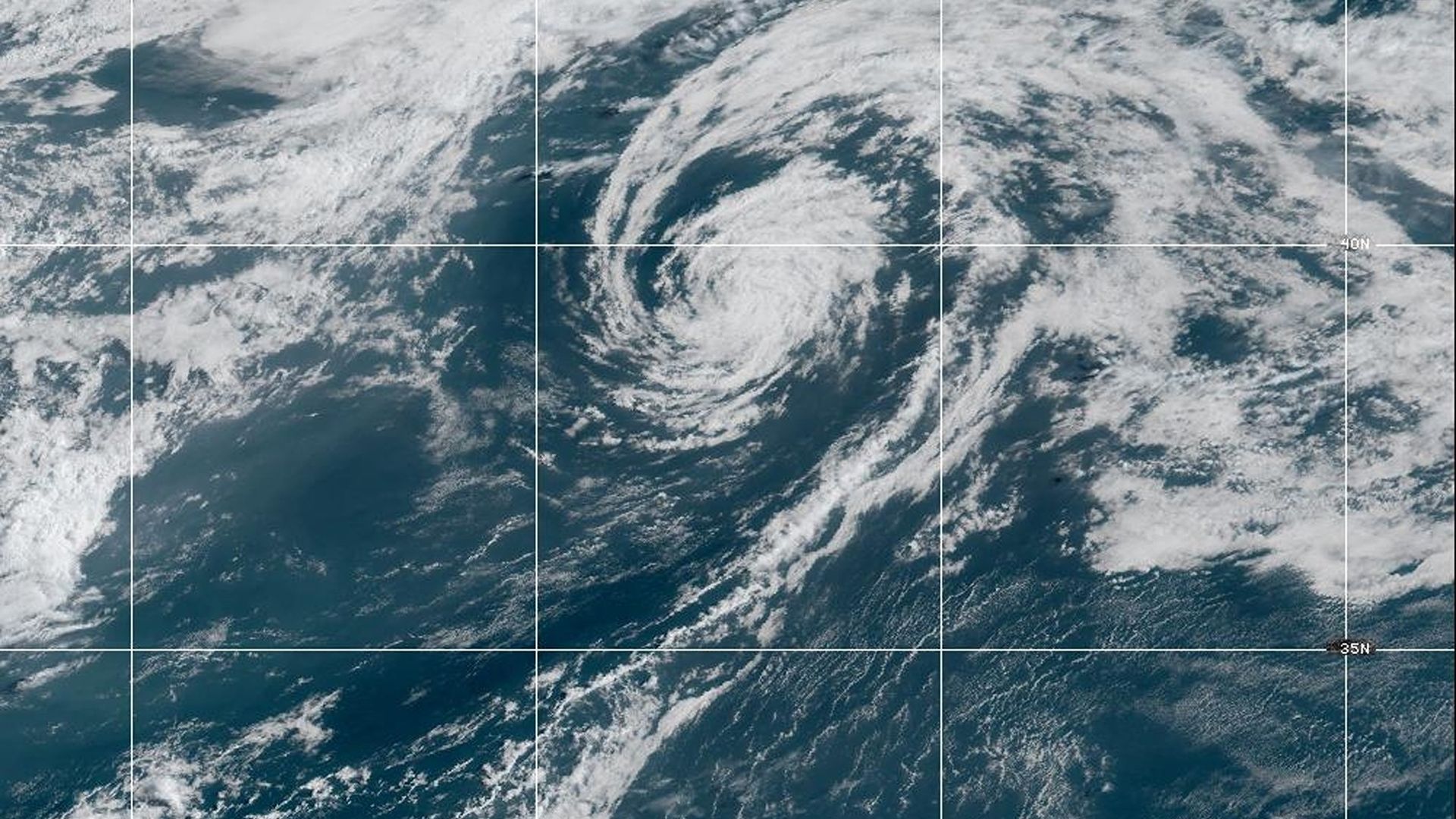
Satellite Image: NOAA
Hurricane Erin's threats prompted mandatory evacuations in the North Carolina Outer Banks on Monday, as forecasters warned the major storm could impact the U.S. East Coast.
The big picture: The storm that flooded Puerto Rico and other Caribbean islands over the weekend isn't expected to make landfall in the U.S., but the National Hurricane Center warns it's expected to bring "life-threatening surf and rip currents" to much of the East Coast, Atlantic Canada, the Bahamas and Bermuda during the next several days.
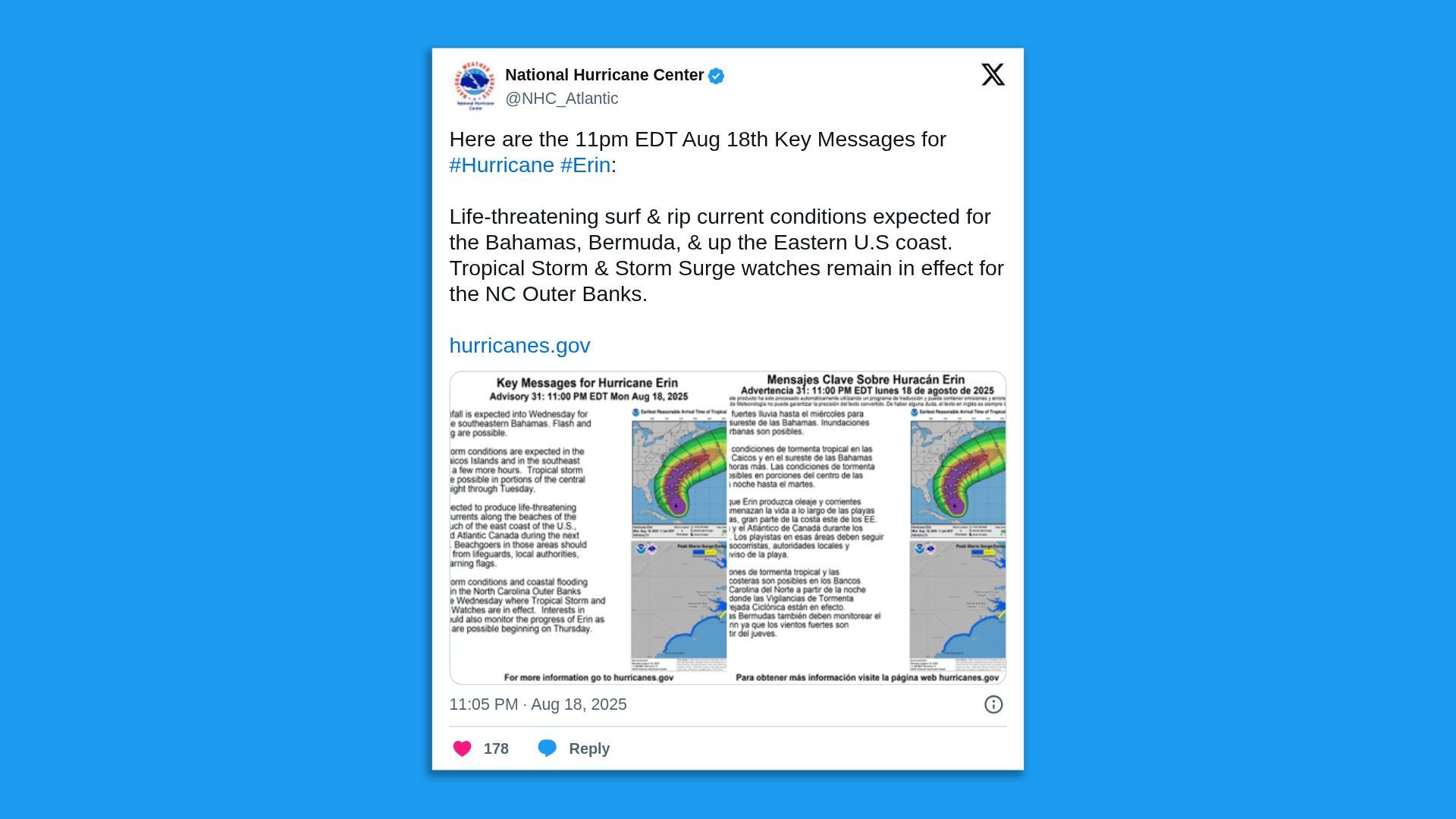
Threat level: Dare County, N.C., is under a state of emergency due to the storm and mandatory evacuation orders were issued for visitors to Hatteras Island. Residents were ordered to leave by 8am Tuesday local time.
- "The island faces potential 15-20 foot breaking waves that could cause structural damage and flood communities, especially along the dune front," Dare County Emergency Management director Drew Pearson said in a video posted to the county's social media accounts.
- NHC director Michael Brennan said in a Monday evening video forecast that the "very large size" of Erin would result in some "very dangerous conditions" along the Outer Banks from late Tuesday and peaking overnight Wednesday into Thursday.
- "We could see widespread inundation of coastal roads like North Carolina Highway 12, some submersion of vehicles, some structural damage, and that ocean water is going to extend well inland in some places and cause some significant threats to life and property," Brennan warned in the video that was posted to the NHC's social media accounts.
Zoom in: A tropical storm warning was in effect for the Turks and Caicos Islands and the southeast Bahamas.
- A tropical storm watch was in effect for the central Bahamas and from Beaufort Inlet to Duck, N.C., including Pamlico Sound.
State of play: Erin dropped from a Category 4 storm to a still-dangerous Category 3 by late Monday.
- "Fluctuations in strength are expected during the next couple of days," the NHC said in its 11pm Monday ET forecast discussion. "However, Erin is likely to remain a dangerous major hurricane through the middle of this week."
- The hurricane was packing maximum sustained winds of 125 mph some 780 miles south-southeast of Cape Hatteras, N.C., as it churned in a northwestly direction at 8 mph.
- The core of Erin was forecast to move away from the southeastern Bahamas and the Turks and Caicos Islands on Monday night and shift east towards the rest of the Bahamas on Tuesday, per the NHC.
- The hurricane was expected to move between Bermuda and the U.S. East Coast by the middle of the week.
Context: Erin formed as a tropical storm on Aug. 11 and it's fluctuated in intensity since it became on Friday the first hurricane of the 2025 Atlantic season.
- The storm reached Category 5 strength with peak winds of 160 mph on Aug. 16 after undergoing extreme rapid intensification, per analysis by Climate Central.
- "Hurricane Erin experienced rapid intensification over sea surfaces warmed by climate change," notes the nonprofit that researches and reports on the impacts of climate change.
- "This rapid strengthening occurred as the storm passed over unusually warm ocean waters that were made up to 100 times more likely by human-caused climate change," Climate Central notes.
More from Axios:
- How climate change supercharged Hurricanes Helene, Milton
- Climate change is increasing hurricane wind speeds, study finds
Editor's note: This article has been updated with new details throughout.
