San Antonio's urban heat islands, mapped

Add Axios as your preferred source to
see more of our stories on Google.
San Antonio is facing growing health risks from urban heat islands, which can exacerbate life-threatening temperatures.
Why it matters: Tracking urban heat islands helps identify at-risk communities and inform strategies to ensure public health as Texas moves into the peak of summer.
How it works: Heat islands are created when roads, buildings and parking lots trap heat.
- Surrounding neighborhoods often lack trees that would otherwise help cool the area.
- Low-income neighborhoods tend to be more vulnerable to heat islands than wealthier ones, making this a key climate equity issue.
The big picture: Urban heat island (UHI) indices are boosting temperatures in 65 major U.S. cities, which are home to a combined 50 million people or 15% of the total U.S. population, according to a new analysis by Climate Central, a nonprofit research group.
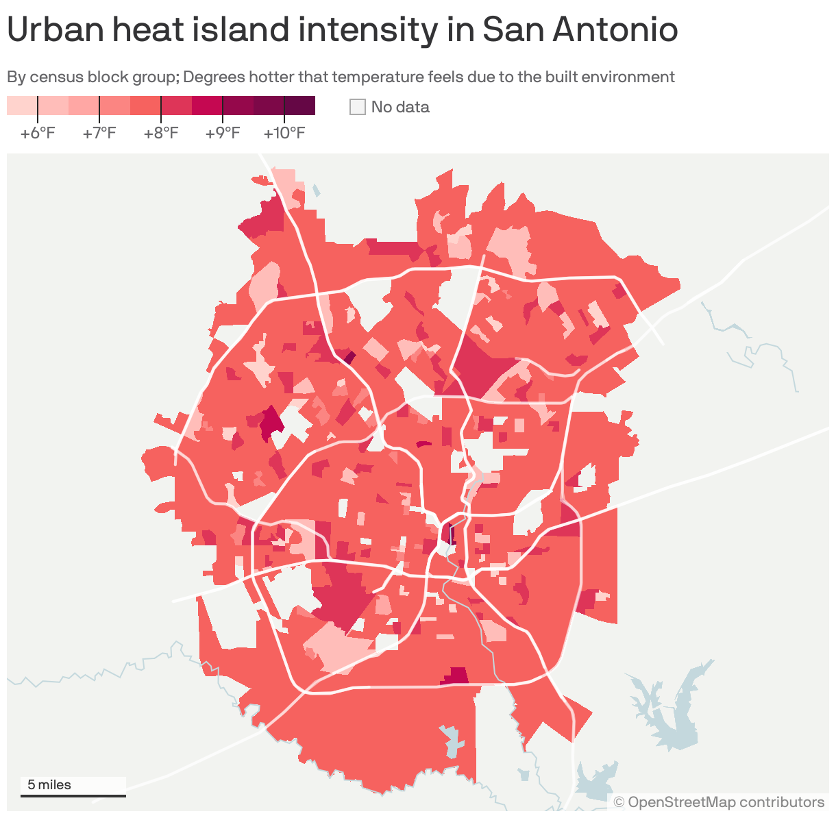
Zoom in: In San Antonio, 88% of the population lives in areas where urban heat islands can raise summer temperatures by at least 8°, per Climate Central.
- It's one of six cities where at least 1 million people are exposed to a UHI index of 8° or higher. The difference could mean life or death in extreme heat.
- San Antonio hit 106 — the hottest days of 2023 — in July and August.
Threat level: San Antonio is seeing an increasing number of heat-related illnesses — at least 787 last year — as summers grow hotter, according to city data.
The intrigue: The worst of San Antonio's heat islands are scattered around the city — deviating from national norms that typically see the brunt borne by lower-income neighborhoods that often lack foliage to cool the area.
- Downtown, from East César E. Chávez Boulevard to Navarro Street, is the single hottest section in town where the UHI index raises the temperature by 9.7°F.
What they did: The City of San Antonio partnered with UTSA's Sustainable Pervasive Urban Resilience (SPUR) Center to track heat vulnerability and allocated resources to the most impacted areas.
- The partnership is an expansion of the Cool Pavement Pilot, which helps cool neighborhoods by treating asphalt to better reflect sunlight and absorb less heat.
- The program treated roads in each of the city's 10 districts last year and has 11 more applications planned for this year.
What they found: The heat vulnerability study identified the most at-risk neighborhoods for extreme heat by combining geographical data with factors like income and race to determine vulnerability.
- The study found that SealMaster, a cool pavement technology, consistently reduced surface temperatures by an average of 3.58°.
- It lowered the maximum surface temperature by 18° compared to conventional asphalt.
What's next: The city is using the findings to guide its heat response strategy, which includes activating cooling centers like swimming pools and senior centers.