Tropical storm watch in effect ahead of torrential rain in Houston


Add Axios as your preferred source to
see more of our stories on Google.
Several Houston suburbs saw flash flooding Tuesday as the region braces for what will likely be the first named storm of the 2026 Atlantic Hurricane season.
Why it matters: Heavy rains leading up to the system's expected landfall Wednesday near the Texas-Louisiana border will only make the risk of flash floods worse, National Weather Service forecasters in Houston say.
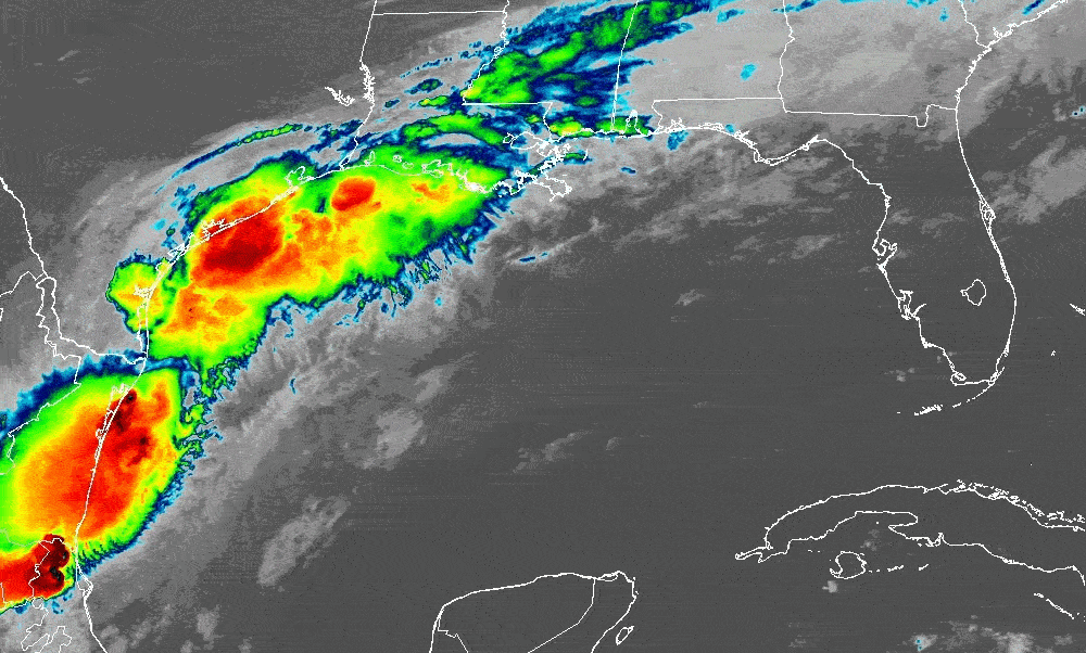
Driving the news: The National Hurricane Center issued tropical storm watches Tuesday for the northwestern Gulf Coast from Sargent, Texas, to Morgan City, Louisiana.
Catch up quick: Rainfall has been sporadic across Southeast Texas since Sunday, saturating the ground and making it difficult for additional rain to be absorbed.
- Between 2 and 6 inches of rain fell across north Harris County and The Woodlands in three hours Tuesday morning. That led to street flooding and several flash-flood warnings from Waller to Conroe.
Threat level: Most of the region's rivers and bayous were within their banks as of 2pm Tuesday, per the Harris County Flood Control District.
The big picture: The storm is expected to dump an additional 4 to 8 inches of rain in parts of Texas, Louisiana, Mississippi, Alabama and Florida, forecasters warn.
- Some spots may get up to 12 inches through Thursday, leading to potentially life-threatening flash flooding.
By the numbers: As of 1pm Tuesday, the system was 55 miles southwest of Corpus Christi, Texas, and moving northeast at 6 mph.
- It had winds of 30 mph and was expected to strengthen. Forecasters expect peak winds of 40 mph, just above the 39 mph threshold required for tropical storm status.
- The system is expected to hug Texas' coast before moving inland late Wednesday or early Thursday. See the latest track.
- Hurricane hunter aircraft were scheduled to fly into the system Tuesday afternoon to gather data on its structure and strength.