Historic storm leaves path of damage across Iowa

Add Axios as your preferred source to
see more of our stories on Google.
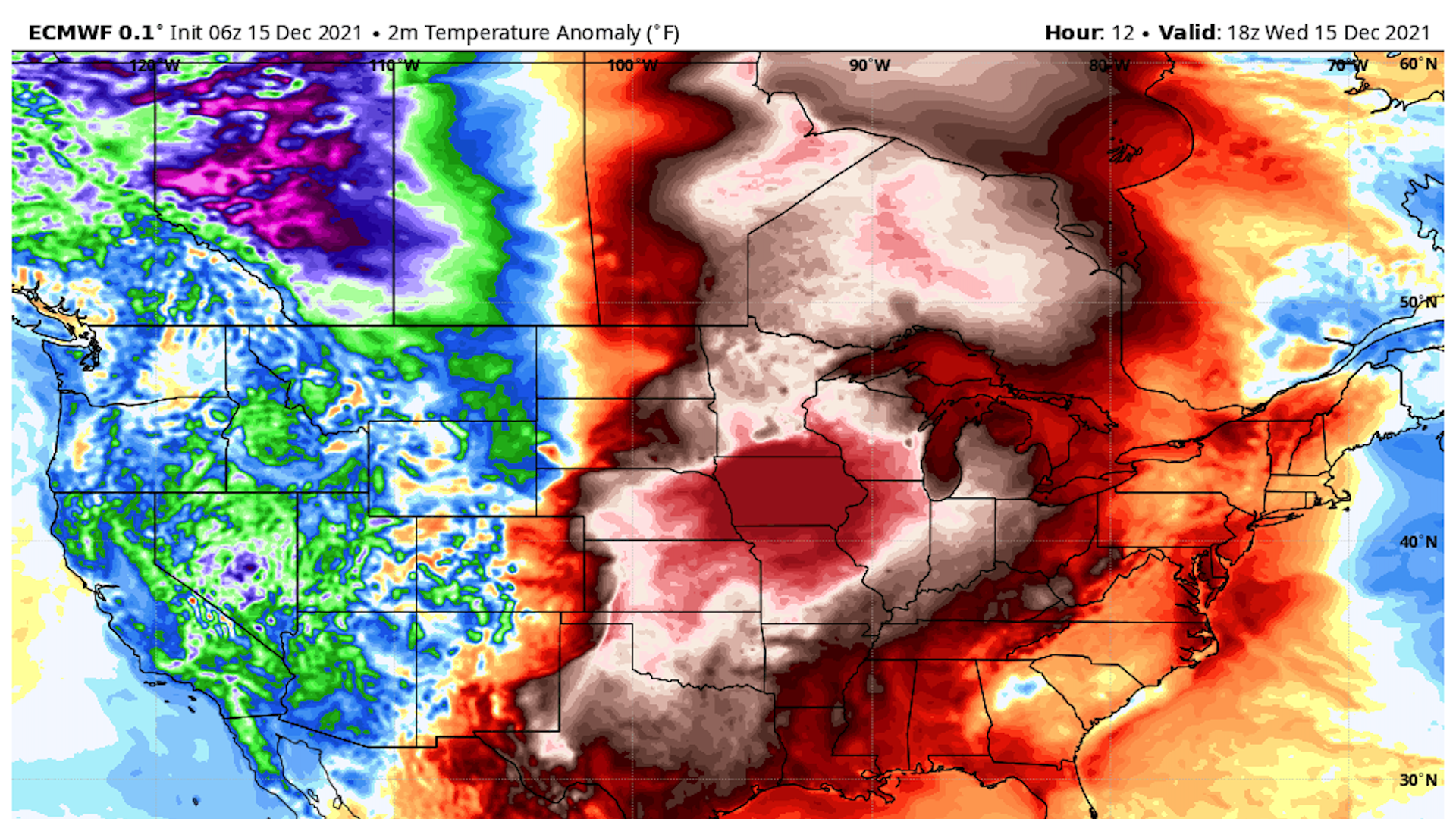
Computer model projection of surface temperature departures from average on Wednesday afternoon. Image: Weatherbell.com
A monstrous line of thunderstorms rapidly moved across a large swath of Iowa Wednesday evening, creating severe weather threats never before recorded in the state in December.
Driving the news: The National Weather Service had only ever issued two tornado warnings in Iowa in December prior to this week, according to tornado researcher Harold Brooks. On Wednesday, forecasters issued more than a dozen in the state.
- At least five tornadoes were sighted in western Iowa, while destructive gusts were recorded up to at least 80 miles per hour. One person died in the storms in Benton County, per Iowa State Patrol.
State of play: Most of the Des Moines metro avoided major structural damage and power outages. There were no reports of injuries.
- Western Iowa endured the most hazardous conditions, with destroyed homes in Bayard — a town of 400 people in Guthrie County, according to early reports from NWS.
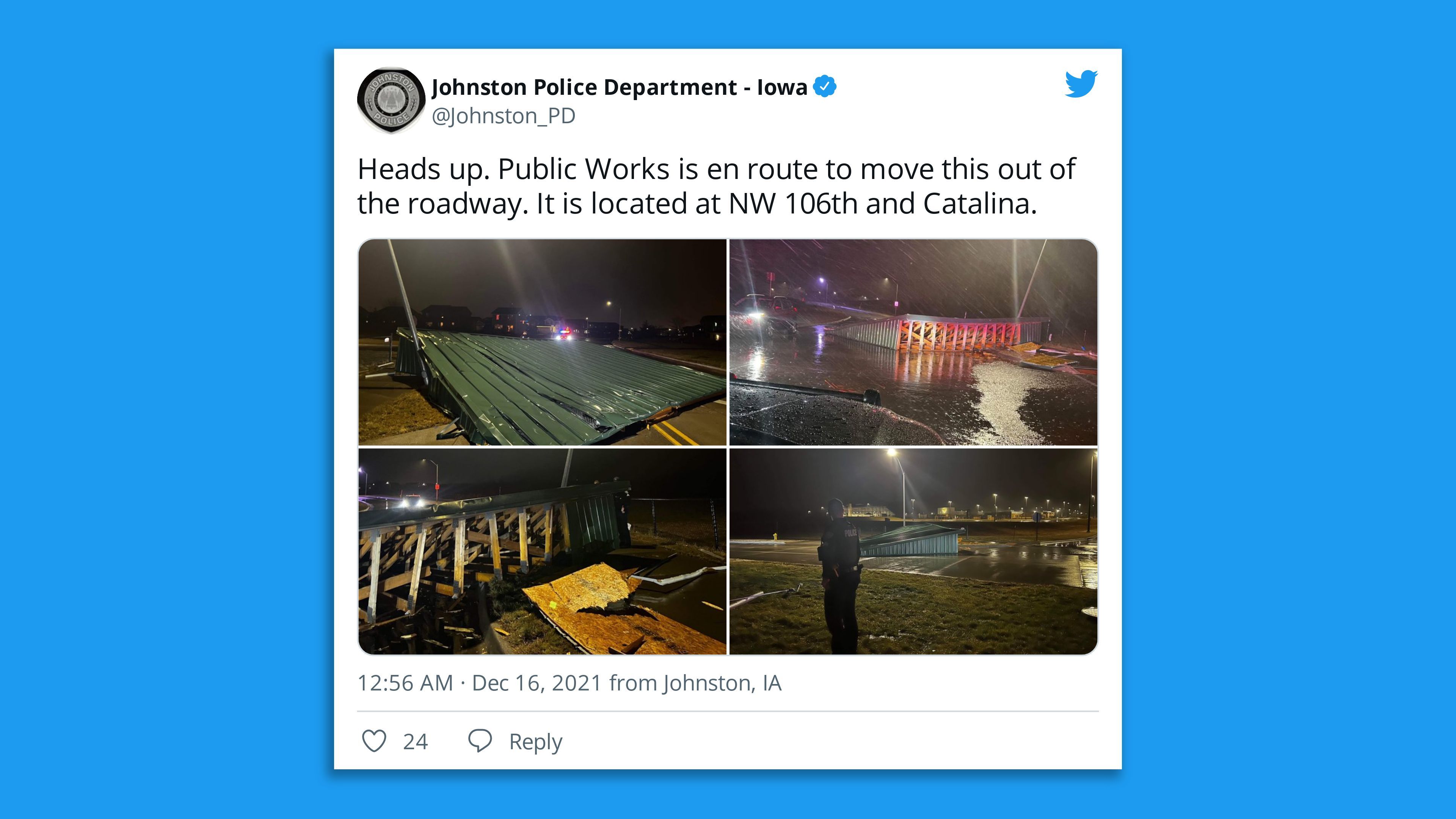
- Weather officials received reports of downed power lines and building damage in rural areas of the state.
- A Des Moines Register photographer documented an overturned semi-truck near Anita.
Details: The NWS measured wind speeds of 75 miles per hour at Johnston High School.
- 16,000 metro households lost power at some point last night. Just over 3,300 are still in the dark this morning, according to MidAmerican Energy. Statewide, at least 105,000 customers lost energy in total yesterday.
- Half a dozen flights scheduled to land at Des Moines International Airport last night were canceled.
Plus: The storm brought record warmth to the region, with Des Moines and several other areas setting all-time high temperatures for the month.
- Readings soared into the 70s all the way to the Iowa-Minnesota border.
What they're saying: The storm didn't directly hit Des Moines last night because “we were on the outside of an angry bubble," Public Works director Jonathan Gano told Jason this morning.
- City crews responded to less than 20 limbs or trees that came down during last nights storm, Gano said.
- Last year’s derecho culled weaker trees and limbs and likely prevented damage in this storm, he said.
Between the lines: For many residents, last night's historic storm felt eerily similar to the 2020 "once-in-a-lifetime" derecho that wreaked destruction in Des Moines and the Cedar Rapids areas.
- But scientists warn that such rare events could become more common. Human-caused climate change is making such warm spells, which enabled the December tornadoes, more likely to occur, Axios' Andrew Freedman reports.
- Unusually mild waters of the Gulf of Mexico also played a role in Wednesday's weather.
Editor's note: This story has been updated with new details throughout.