The 2024 Atlantic hurricane season keeps underperforming expectations

Add Axios as your preferred source to
see more of our stories on Google.
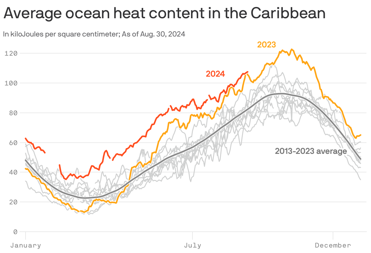
The Atlantic Ocean is near record warm, and a favorable La Niña climate cycle is developing in the tropical Pacific Ocean. Yet at what is normally the peak of hurricane season, the ocean basin has stubbornly stayed in a deep slumber.
Why it matters: Diagnosing what is keeping storms from forming, and why computer models keep showing phantom storms, could improve forecasts.
The big picture: It was only last week that we, along with others, wrote that a long-awaited uptick in hurricane activity would soon occur, a prediction supported by the major computer models used for forecasting such storms.
- These models showed multiple storms forming during the next two weeks, from the eastern Atlantic to the Caribbean. Then, in an unnerving example of the windshield-wiper-effect, models alternated between showing a powerful hurricane in the Gulf of Mexico late this week and no storm at all.
- Today, areas of showers and thunderstorms are having trouble organizing into coherent tropical cyclones, and the National Hurricane Center is giving two areas a 40% chance of developing in the next 7 days at best.
- It appears the same hindrances to storms during the second half of August are still present and may continue to be through much of September.
- If that happens, October and November would need to play catch up on storm activity, making it unlikely that the seasonal forecasts will verify.
Yes, but: One landfalling system can be devastating, whether in a slow or busy year.
Zoom in: Some hurricane experts say it is no longer likely that the high-end numbers in these forecasts will verify, while others emphasize the considerable uncertainties involved in such predictions at this time of year.
- "I'm not willing to bet against the back part of the season," said Michael Lowry, a hurricane specialist at WPLG TV in Miami, noting past seasons that had more than a month of inactivity only to end up above average.
- Still, there is a growing potential for the outlooks for the 2024 Atlantic hurricane season to be a "bust of historic proportions," said meteorologist Sam Lillo in a post on X.
- Some of the inhibiting factors holding back Atlantic storm activity are structural and clear, and others are more sneaky.
The intrigue: The African Monsoon and related Intertropical Convergence Zone (ITCZ) are still located well to the north of their typical position, spawning complexes of thunderstorms that are dousing the Sahara Desert with historic rainfall, a pattern forecast to continue.
- These tropical storm seedlings then move northwest, in a highly unusual fashion, off the African coast near Mauritania or Western Sahara.
- This puts them over the colder waters of the Canary Current, where the thunderstorms, deprived of a heat source, collapse.
- In a typical, active hurricane season, tropical waves tend to exit the African coast further to the south, over Senegal, placing them over warmer seas.
- Recent research suggests unusually hot waters in the Mediterranean and North Atlantic, as currently exist, can push the ITCZ and African Monsoon north into the Sahara.
There is also an anomalously high amount of dry air getting entrained into tropical waves as they move off of Africa, and to the west. This too hinders storm development.
Between the lines: Meteorologists and climate scientists are also debating another factor holding back storm formation: unusually warm air at high altitudes.
- The atmosphere over the tropical Atlantic has been remarkably stable during much of the hurricane season, with temperatures running well above average at about 35,000 to 45,000 feet.
- This vertical temperature structure, with warm air near the surface and at high altitudes, tends to prevent the air from rising, cooling and condensing into clouds and forming organized storms
- Why the upper-level warming is so prevalent is an area of active research. One hypothesis points to water vapor vaulted into the stratosphere from the explosive eruption of the Hunga Tonga-Hunga Ha'apai undersea volcano in 2022.
What they're saying: Jim Kossin, an expert on hurricanes and climate change, says the ongoing lull shows the limits of seasonal storm forecasting.
- "Is it possible that September and October will be so hyperactive that the forecasts will verify in spite of the quiescent August? Maybe, but increasingly unlikely as the window of opportunity slowly closes as the days tick by," Kossin tells Axios.
The bottom line: The NOAA, university researchers and private forecasting companies all projected an unusually busy Atlantic season this year, in large part based on record-warm ocean temperatures throughout the Atlantic.
- The unusually hot waters are still present, but the storms are absent.
