Record-breaking, widespread and stubborn heat wave to blanket U.S. this week

Add Axios as your preferred source to
see more of our stories on Google.
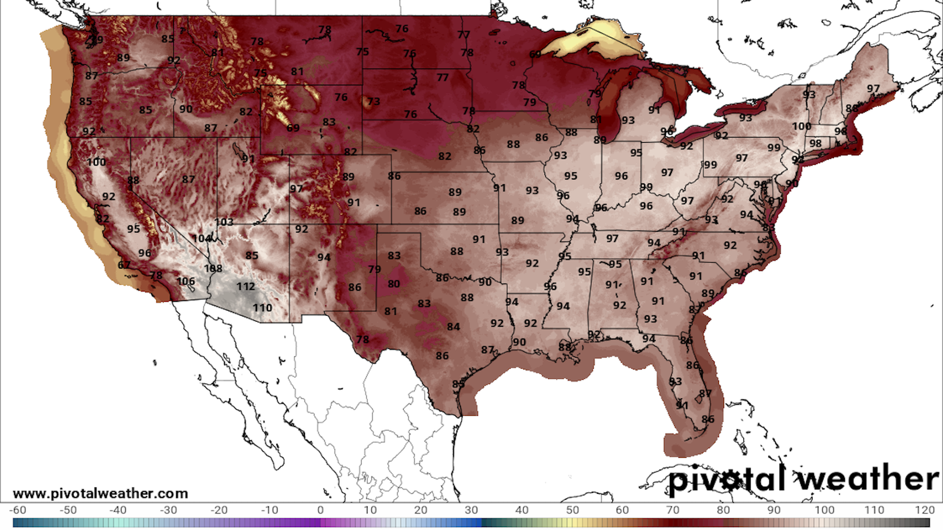
National Weather Service forecast high temperatures on June 20, showing the Ohio Valley to East Coast heat wave. Image: Pivotal Weather.
A June heat wave for the record books is set to send temperatures soaring from the Midwest and Ohio Valley to the Mid-Atlantic and Northeast beginning Sunday and continuing into the coming weeks.
Why it matters: Extreme heat is the top weather-related killer in the U.S. For millions of people, it will be the first heat wave of the season, heightening health risks.
Threat level: By Sunday, 268 million people in the U.S. are forecast to see air temperatures reach or exceed 90°F, with many of them experiencing heat indices at or above 100°F.
- Big cities that will be affected by this event include Chicago, Columbus, Albany, Syracuse, Pittsburg, Washington, D.C., New York City, Hartford and Boston.
- Even northern Maine, which typically is just emerging into warmer conditions at this time of year, is likely to see temperatures soar into the upper 90s°F.
- Some computer models show that the center of the strong ridge of high pressure, also known as a heat dome, is likely to slide from the southern Great Lakes region to the northern Mid-Atlantic during midweek, and into New England.
The big picture: The heat dome is projected to form across the East and may set records for its intensity at this time of year.
- This will translate to days of hot, humid and rain-free weather and little temperature relief at night, particularly for areas to the west of the heat dome where a sultry southwesterly air flow will dominate.
- The projected intensity of the heat dome in model simulations would depart from any previous events at this time of year in that location — an indication of the highly anomalous nature of this heat wave.
- Even if the heat dome does not set intensity records, it is clear this will be a long-duration extreme heat event, heightening the public health threat.
Context: Human-caused climate change is making heat waves more likely, more intense and longer-lasting.
- Studies have shown, in fact, that some heat waves would have been "virtually impossible" to occur without human-caused climate change.
By the numbers: National Weather Service forecasts for Wednesday and Thursday show highs in the mid-to-upper 90s stretching from Missouri to northern Maine.
- In Washington D.C., the National Weather Service forecasts highs at about 93 to 98°F during the Monday through Friday period. This would be unusually hot for this time of year, considering the city has not hit 100°F since 2016.
- In Chicago, the NWS predicts a peak in the heat on Monday through Wednesday, with a high temperature of 95°F.
- Boston would see highs of 97°F late next week, per the NWS.
- It is possible that some locations in the Mid-Atlantic and Northeast will see temperatures climb to or above 100°F late this week, given the computer model guidance, which has trended warmer in recent days.
Yes, but: While the Ohio Valley, Great Lakes and East roast, some snow could fall in the Rockies as an unusually cold air mass settles in there.
Zoom out: Dozens of daily temperature records are in jeopardy from this heat wave, as are June hot streak milestones.
- Even a few monthly records may be broken, with temperature anomalies of 10°F to 20°F above average for this time of the year.
- The NWS has begun to hoist excessive heat watches for the Monday through Friday period in the Midwest and Northeast, and its new joint heat risk product, developed with the CDC, shows top-tier risk levels moving from the Midwest, including Chicago, to the Northeast during mid-to-late week.
- At Levels 3 and 4, which correspond to "Major" and "Extreme" risk, the extreme heat will affect those without adequate hydration or access to effective cooling.

The intrigue: The NWS went all the way back to 1994 to find a comparable extreme heat event of this magnitude, as well as in the same region and time of year.
- The NWS said in a forecast discussion that the heat wave will likely continue beyond Friday, as the heat dome slides west-southwest but does not slink away completely.
- In fact, late in the week may be the peak of the heat wave in the Mid-Atlantic, as surface-level winds turn west-southwest, pumping even hotter air into the region.
The bottom line: It's projected to be an unusually hot summer— and this first major heat wave may settle in for the long haul.
