Drenched South Florida faces fresh flood threats


Add Axios as your preferred source to
see more of our stories on Google.
A man helps attempt to pull a woman's car out of a canal in Hallandale Beach, Florida, on Thursday. Photo: Joe Raedle/Getty Images
Heavy to excessive rainfall may bring "considerable to locally catastrophic urban flooding" across South Florida through Friday, the National Weather Service warns.
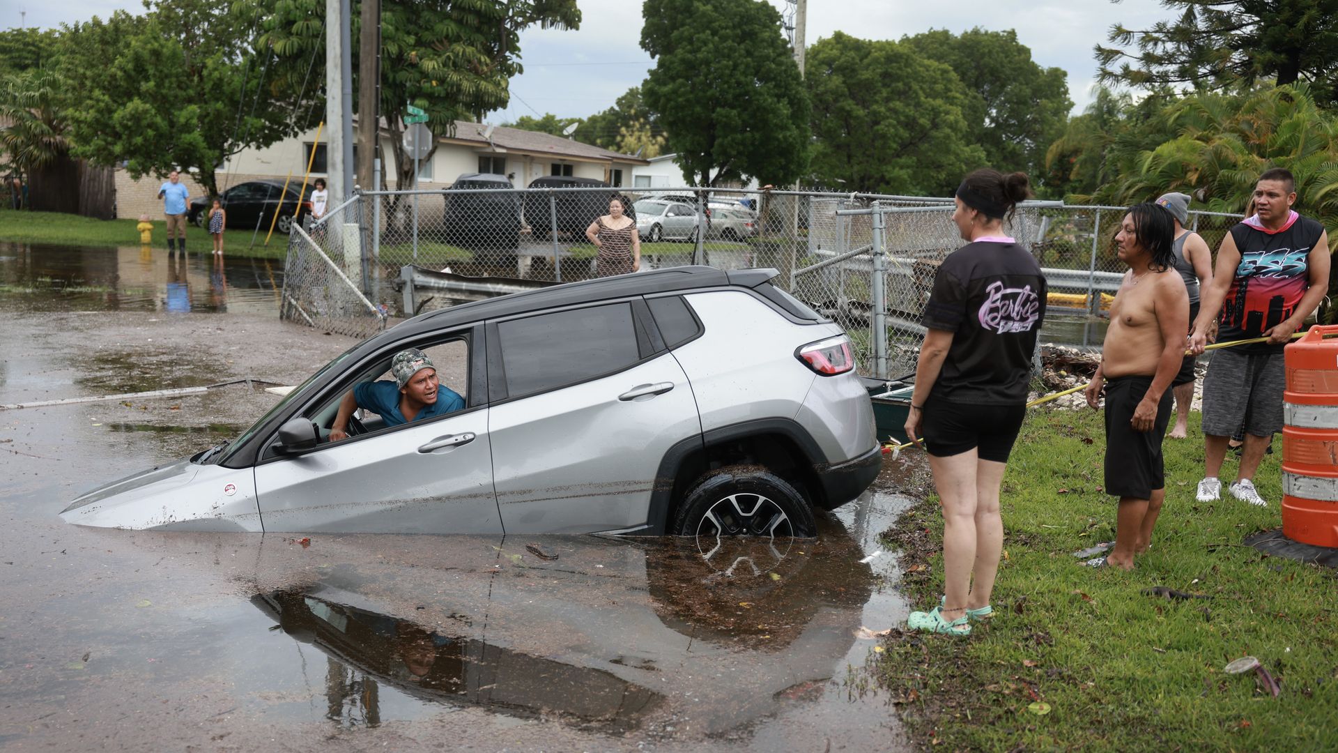
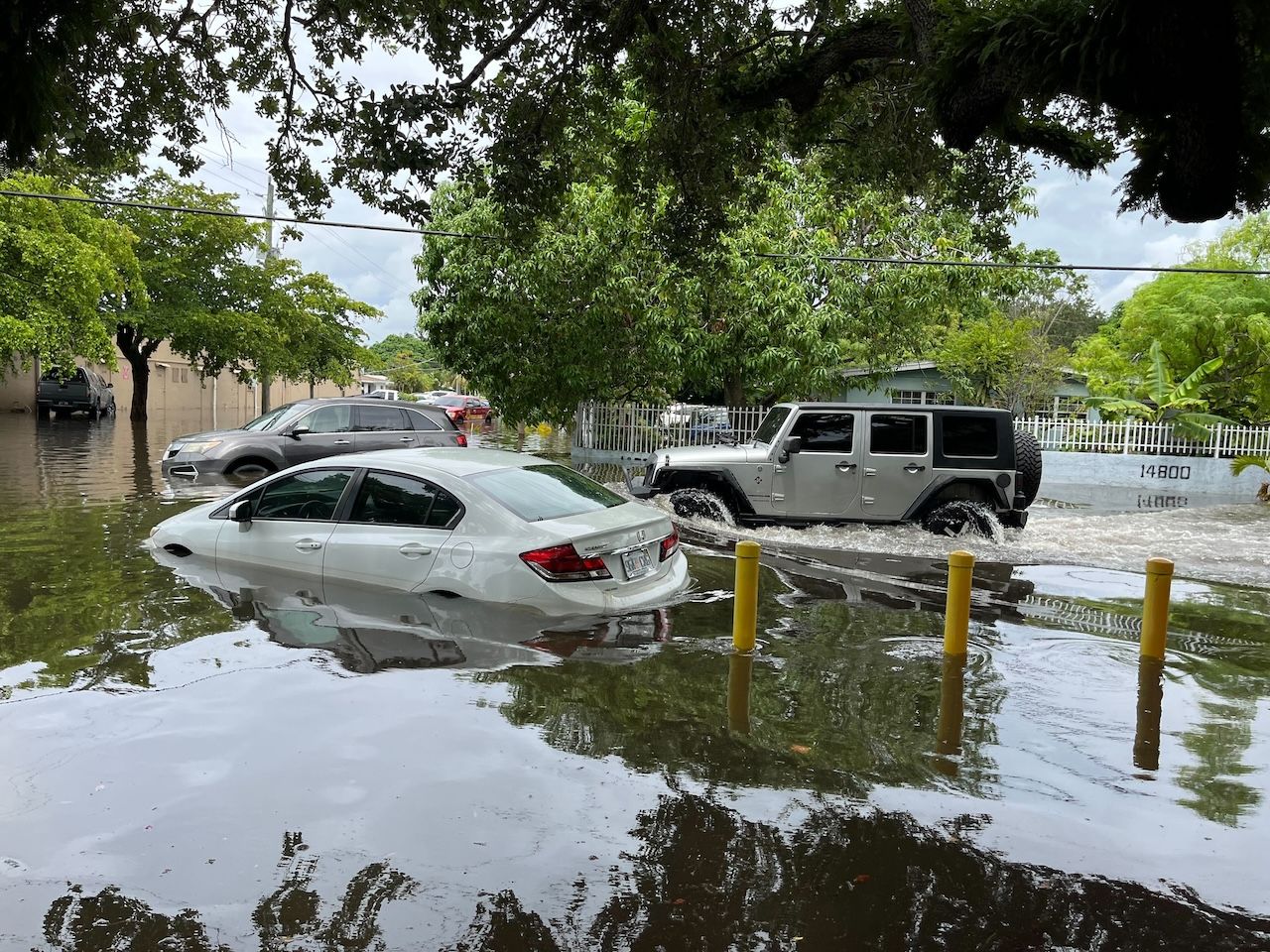
The big picture: The intense downpours that flooded streets in Miami and Fort Lauderdale and prompted Florida Gov. Ron DeSantis to declare an emergency in affected counties and severely disrupted travel on Wednesday eased on Thursday evening, but South Florida remains under a flood watch through 8pm Friday.
- The severe weather that began on Tuesday resulted in temporary ground stops at key airports on Wednesday, closed roads and prompted numerous flash flood warnings, including in the Miami metro area through 8pm Thursday ET.
- Over 1,200 flights into or out of Miami International Airport, Fort Lauderdale-Hollywood International Airport and Orlando International Airport were delayed or canceled, per FlightAware.
Threat level: Technical forecast discussions from the NWS forecast office in Miami and the Weather Prediction Center both pointed to the potential for most areas affected by flooding Wednesday to see 4- to 8-inch amounts of rain on Thursday into Thursday night, with isolated 10-plus inches possible.
- If this occurs over the hardest-hit areas from Wednesday, the results could be disastrous.
- In fact, rainfall rates of less than 1-inch per hour could be sufficient to send water rising once again, particularly in areas between Miami and Fort Lauderdale, which received 10 to 15 inches of rain Wednesday.
State of play: Flood watches were in effect for all of South Florida through Friday evening.
- Parts of South Florida, along the I-75 corridor from Naples to Fort Lauderdale and points south to Miami, were under a "high risk" of seeing excessive rainfall leading to flooding Thursday, translating to at least 70% odds.
- High risk outlooks are rare, and about one-third of all flood-related fatalities and four-fifths of flood damages occur on such days, per the NWS.
- "Widespread flash flooding is expected," NWS Miami stated on X. "*Locally catastrophic flash flooding is possible.*"
- Ongoing rounds of thunderstorm activity were expected to continue through Friday before subsiding by the weekend, the NWS said in a forecast discussion.
Context: The heavy rain and flooding is the result of a firehose of tropical moisture flowing from southwest to northeast across the unusually warm waters of the Gulf of Mexico.
- Circulations within this moisture feed are acting as focus areas for the heaviest rainfall.
- On Wednesday, the highest amount of precipitable water on record in Miami during June since 1948, as detected by a weather balloon, was recorded — an indication of the extreme rainfall potential. It indicates the amount of liquid water in the air above a location, which can be wrung out as rain.
- As the climate warms, extreme precipitation events such as this one are becoming more frequent and intense, studies show.
- Aging infrastructure built for a climate that no longer exists is also exacerbating the problem.
Zoom out: South Florida was hit by a severe flash flood last year, which closed down Fort Lauderdale-Hollywood International Airport for days.
- Between flash flooding, coastal flooding from rising seas and the threat of hurricanes, home insurers have been fleeing the state, leaving many homeowners without coverage due to rate spikes.
- "Repeated severe hits to South Floridian pocketbooks, with many people not being able to afford or even find insurance," Miami television meteorologist John Morales wrote on X.
- "It's increasingly hard to live here."
Go deeper... Photos: Cars left stranded on South Florida's flooded streets
Editor's note: This a breaking news story. Please check back for updates.
