Making sense of January's wild weather

Add Axios as your preferred source to
see more of our stories on Google.
 Open embedded content from datawrapper.dwcdn.net
January's icy weather demonstrates the differences between regional weather and climate conditions.
Why it matters: The former is governed by disturbances in the jet stream and other factors, while the latter is more driven by influences such as human emissions of greenhouse gases.
Driving the news: January has been cold, if not downright frigid, across much of the Lower 48 states.
- A polar vortex-linked Arctic blast has engulfed much of the country, while a series of deadly extreme weather events have struck.
Zoom in: The most unusually cold air on the planet has been parked over the Lower 48 states this week, leading to a deadly, record snowstorm along the Gulf Coast.
- Ten to 12 inches of snow fell in southern Louisiana, while all-time record snowfall also occurred in Mobile, Ala., and Pensacola, Fla.
- The cold spilled so far south that the snow that fell in New Orleans' French Quarter was light and fluffy, and prone to drifting. In short, an alien phenomenon for that location.
- Typically during Arctic outbreaks, the Gulf Coast stays dry or receives a wintry mix. But this time, a storm formed along a frontal zone and tapped into unusually warm Gulf of Mexico waters.
- The comparatively warm and humid air was vaulted northward, where it overran the cold, dry and dense air, producing snow.
In other words, the same factor — unusually hot seas that helped lead to rapidly intensifying Gulf hurricanes last year — also helped produce record snows from Texas to the Carolinas.
The intrigue: January has also brought climate-linked disasters that have played out in the West, with the deadly LA-area wildfires.
- They began in early January amid abundant dry vegetation from what scientists refer to as hydroclimate whiplash, as two extremely wet winters were followed by record warmth and dry conditions last summer into this winter.
- Factors apart from climate — such as development patterns — have also played an important role in these blazes.
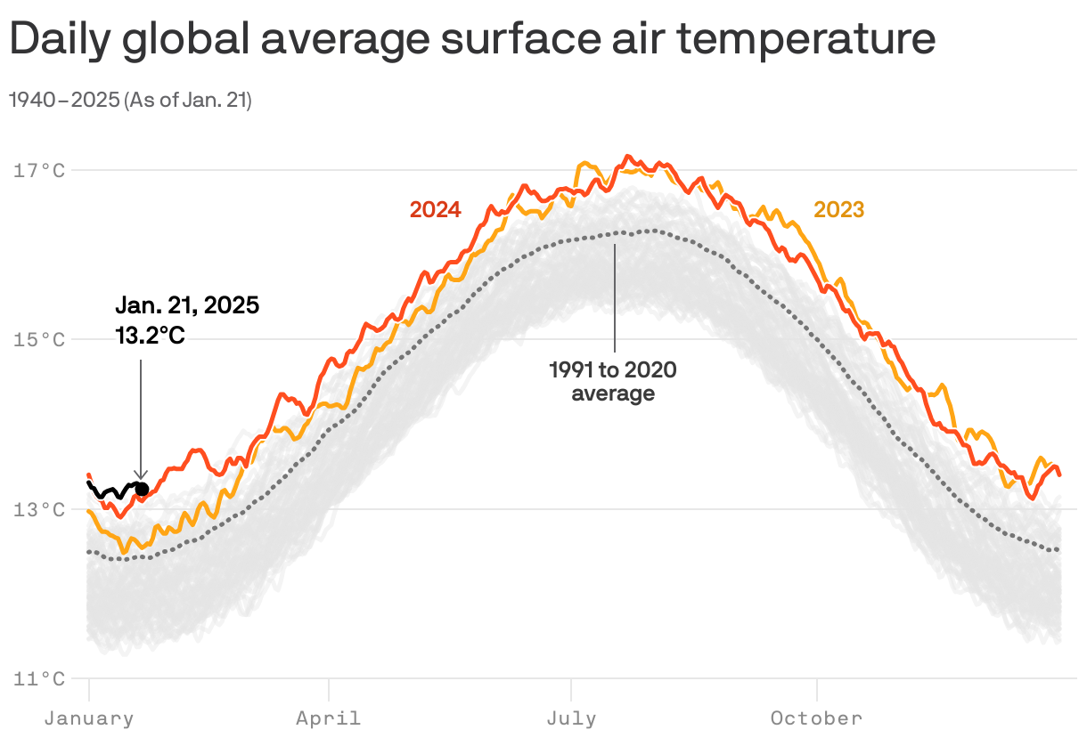
Zoom out: Following the hottest year on record in 2024, daily global average surface temperatures have been at or near record levels throughout the month.
- This is in keeping with the trend of record warmth seen during the period from 2023 onwards.
- What's unusual about the global warmth since late 2024 is that it's unfolding while the tropical Pacific Ocean has been exhibiting signs of a La Niña. (La Niña officially arrived on Jan. 9.)
- These natural climate events tend to damper global average surface temperatures, but this cooling effect may be becoming less effective over time as the planet warms more significantly and rapidly.
The bottom line: Just because it's freezing — and maybe even extremely snowy — where you are does not mean that it's unusually cold worldwide.
