"Major" winter storm ushers in severe Arctic outbreak across U.S.

Add Axios as your preferred source to
see more of our stories on Google.
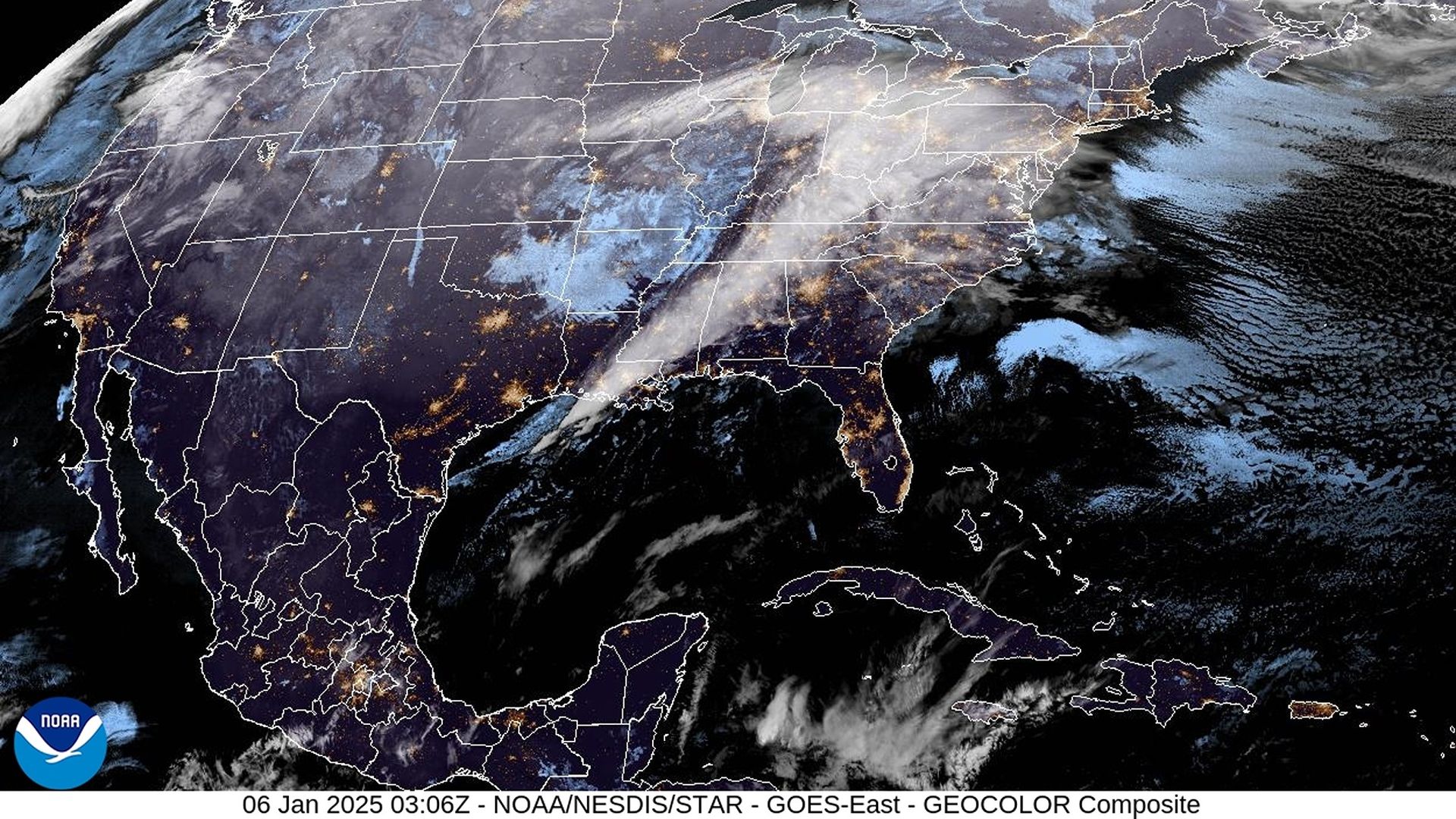
Satellite image: NOAA
A high-impact winter storm is bringing more than a foot of snow, hazardous ice and severe weather Sunday through Tuesday to tens of millions of people, many of whom are unaccustomed to such conditions.
Threat level: In Kansas City, heavy snow fell throughout Sunday, following a skating rink of ice on Saturday. In the South, severe thunderstorms prompted tornado warnings. All of this inclement weather is headed for the Mid-Atlantic region, where D.C. schools closed in anticipation of up to a foot of snow.
- An Arctic outbreak partially tied to the polar vortex encircling the far north was moving into parts of the U.S. on Sunday night. It's set to bring some of the coldest air in years to locations east of the Rocky Mountains during the next two to three weeks.
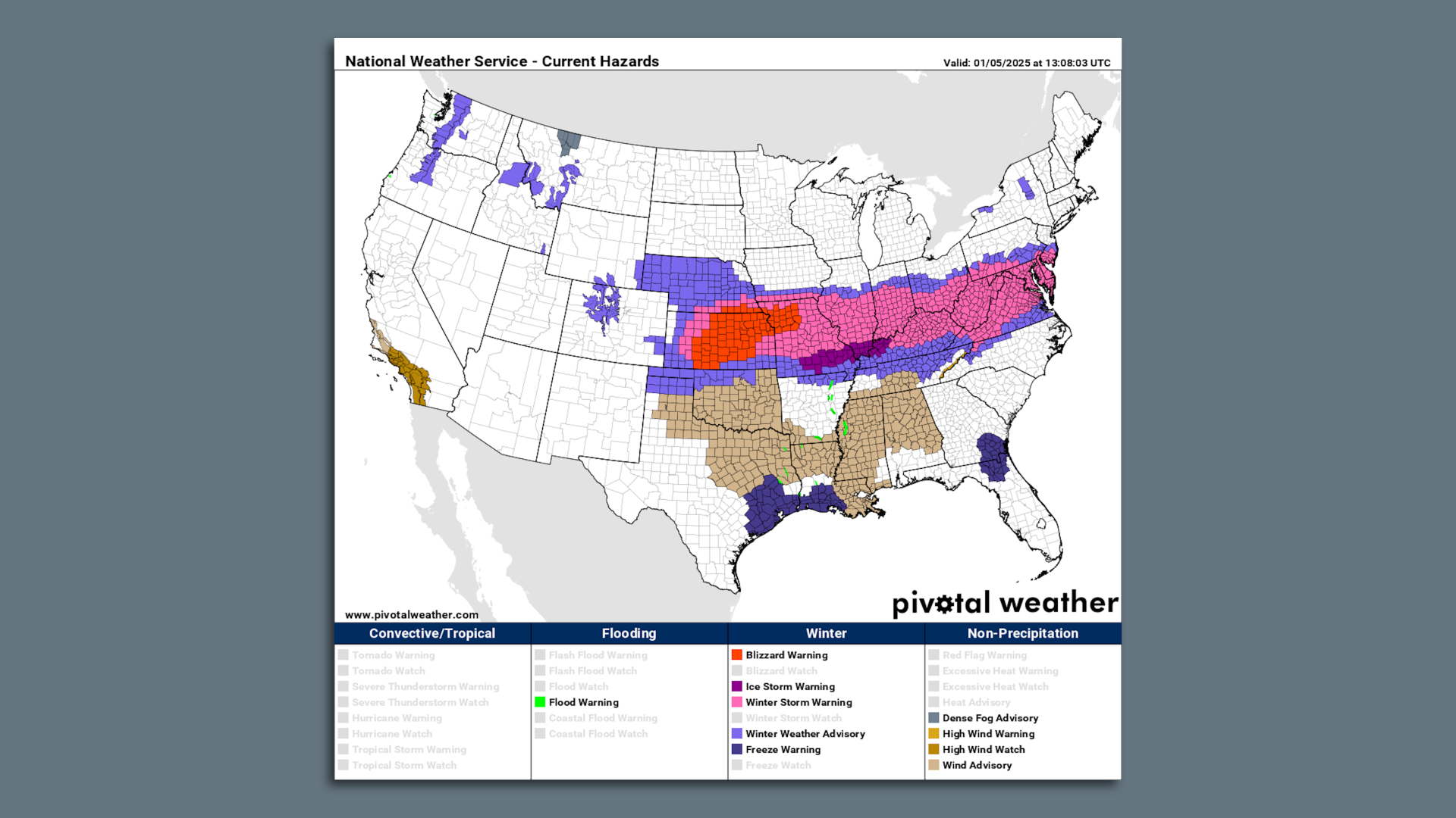
By the numbers: More than 110 million people, roughly a third of the U.S. population, were under some type of precipitation-related winter storm alert early Monday, according to the National Weather Service. This includes everything from a blizzard to ice storm warnings.
- An estimated 61,000 customers were without power in Kentucky, as were over 47,000 in Indiana and nearly 35,000 in Missouri — mostly due to ice early Monday.
- In Illinois, the state emergency management agency said on X just before midnight that about 36,000 customers were without electricity in the state's south amid "many reports of downed trees and tree branches" after freezing rain and sleet "burdened trees with extra weight."
- More than half the U.S. population is expected to see temperatures drop to 32°F or below during the next seven days — with many seeing far colder temperatures.
The big picture: The storm will help pull more bitterly cold Arctic air southward on its heels, as blustery winds kick in from the northwest. Most of the U.S. will see temperatures dip down to the freezing mark.
- With temperature anomalies of 15°F to 25°F below average for this time of year, the cold will be noteworthy more for its duration than its intensity, however.
- The Electric Reliability Council of Texas (ERCOT) on Sunday issued a Weather Watch from Jan. 6-10 due to forecast cold weather. Texas' grid has been vulnerable to winter and summer weather extremes, though solar power helped keep supply stable during an Arctic blast last year.
- Computer models are hinting that another major storm, perhaps followed by even more intense cold, could occur late in the coming week.
- Since January is typically the coldest time of year, any negative temperature departures from average can result in significant cold.
Where it is snowing and how much will fall
Zoom in: The National Weather Service is warning of "major" winter storm impacts across central and northern Kansas, into Kansas City, where more than a foot of snow and sleet could fall this weekend.
- The NWS issued a rare blizzard warning for central and eastern Kansas and parts of Missouri, including areas near Kansas City, as strong winds and heavy snow reduced visibility to near zero.
- Unusually heavy snow will also accumulate near St. Louis, where "major" storm impacts are likely, according to NOAA's Winter Storm Severity Index.
- For these regions, "This could be the heaviest snowfall in over a decade," the NWS stated via a post on X. The agency warned of "dangerous to impossible driving conditions" along with "considerable disruption to daily life."
- Another area of major winter storm impacts is forecast for the Mid-Atlantic, specifically the Washington metro area, where 6 to 12 inches of snow could fall between Sunday night and early Tuesday morning.
If these amounts verify, it would be the biggest snowstorm in these areas since at least 2022, and could eclipse snow totals from some entire winter seasons in recent years.
Between the lines: Perhaps the most impactful winter storm-related threat is freezing rain.
- To the south of the extensive snow shield, a strip of damaging ice will build up on trees and power lines, potentially knocking out electricity to millions of people from central Kansas to West Virginia Sunday into Monday.
- "Dangerous travel conditions, widespread tree damage, and prolonged power outages are expected along this corridor," the NWS stated in an online discussion.
- Such outages could last many days, particularly because of the lack of experience with such hazards in this region.
The intrigue: After this storm exits into the Atlantic on Tuesday, forecasters will be eyeing both a lobe, or piece, of the polar vortex swirling over Canada, which could be directed southward into the U.S. in about a week, or remain trapped in Canada.
- Also facing scrutiny will be the potential for any other major winter storms given the cold air entrenched across the U.S.
Fun fact: The annual meeting of meteorologists from around the U.S. and abroad takes place next week, and is infamous for prompting its own extreme weather.
Go deeper: In photos: Major winter storm blasts much of the U.S.
Editor's note: This article has been updated with new details throughout.
