Arctic air from Siberia to cause temperatures to plunge across Midwest, East

Add Axios as your preferred source to
see more of our stories on Google.
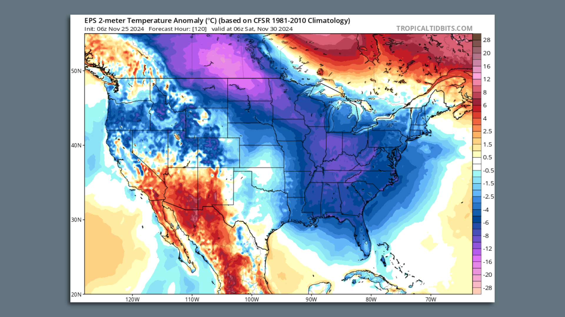
Map showing a computer model projection of temperature anomalies on Nov. 30. Image: Tropicaltidbits.com
Late November and early December look to be unusually cold across the Upper Midwest, Great Lakes region, and into the East, forecasts show.
Why it matters: The cold air will provide a boost to the early winter sports season in multiple states. However, the cold snap doesn't appear to be accompanied by any major snowstorms other than in interior New England.
- Temperatures may drop to at least 20°F below average for the time of year from the Plains and Upper Midwest east to Michigan, and — to a lesser extent — southeast from Ohio to the Mid-Atlantic region.
Zoom in: High temperatures by the Saturday following Thanksgiving may only reach the upper 30s°F to low 40s°F in Washington, D.C., and hold in the low 30s°F in New York City and Boston by Sunday.
- In the Midwest, Chicago could see highs below freezing over the post-Thanksgiving weekend, while temperatures in Minneapolis dip into the upper teens for high temperatures.
- And in the northern Plains, air temperatures may struggle to get out of the single digits to low teens from Friday and through the weekend.
- The cold is likely to last well into the first week of December, as the weather pattern across the U.S. flips from how it started the fall, with a northward bulge, or ridge, in the jet stream across the West, and a dip, or trough, in the jet across the East.
- This setup will allow frigid Arctic air from Siberia to slink south-southeastward across Canada, eventually passing through customs at the U.S.-Canadian border in northern Minnesota this week.
Reinforcing surges of cold air will help lower temperatures further to the south and east over time.
The big picture: The source of the air mass moving into the U.S. from Canada lies in Siberia, where air temperatures were as cold as minus-30 to minus-40°F late last week and into the weekend.
- The large-scale weather pattern is moving that frigid air over Canada and southward, though temperatures are moderating as it moves closer to the continental U.S.
- Such a setup featuring large-scale northerly air flow is often referred to as a "Siberian Express" pattern.
Yes, but: Despite the unusually cold conditions that are expected, the U.S. as a whole may stay rather warm overall.
- Also, cold snaps today tend not to be as cold as frigid air outbreaks a few decades ago. This matches the long-term trend showing that winter is the fastest-warming season in much of the continental U.S.
- In addition, the drought conditions prevalent across the East are unlikely to subside: Other than a Thanksgiving Day into Thanksgiving weekend storm plus lake-effect snow, relatively little precipitation is anticipated.
The intrigue: Seasonal forecasts issued ahead of this winter showed a likelihood for the season to be unusually mild and dry across the South, and milder than average in the East as well.
- This was predicated on the development of La Niña conditions in the tropical Pacific Ocean.
- However, the La Niña hasn't shown up yet. If and when it does, it is expected to be a weak event, which may limit its effects on the winter season.
- This means that more highly variable conditions, with cold snaps interspersed with milder swings, may be more likely in parts of the country.
A weak or nonexistent La Niña could increase the odds somewhat for a significant East Coast snowstorm or two this winter, as well.
The bottom line: Tens of millions of people should get ready for the coldest weather since the winter of 2023-2024.
