West Coast bomb cyclone continues with heavy rain, flooding

Add Axios as your preferred source to
see more of our stories on Google.
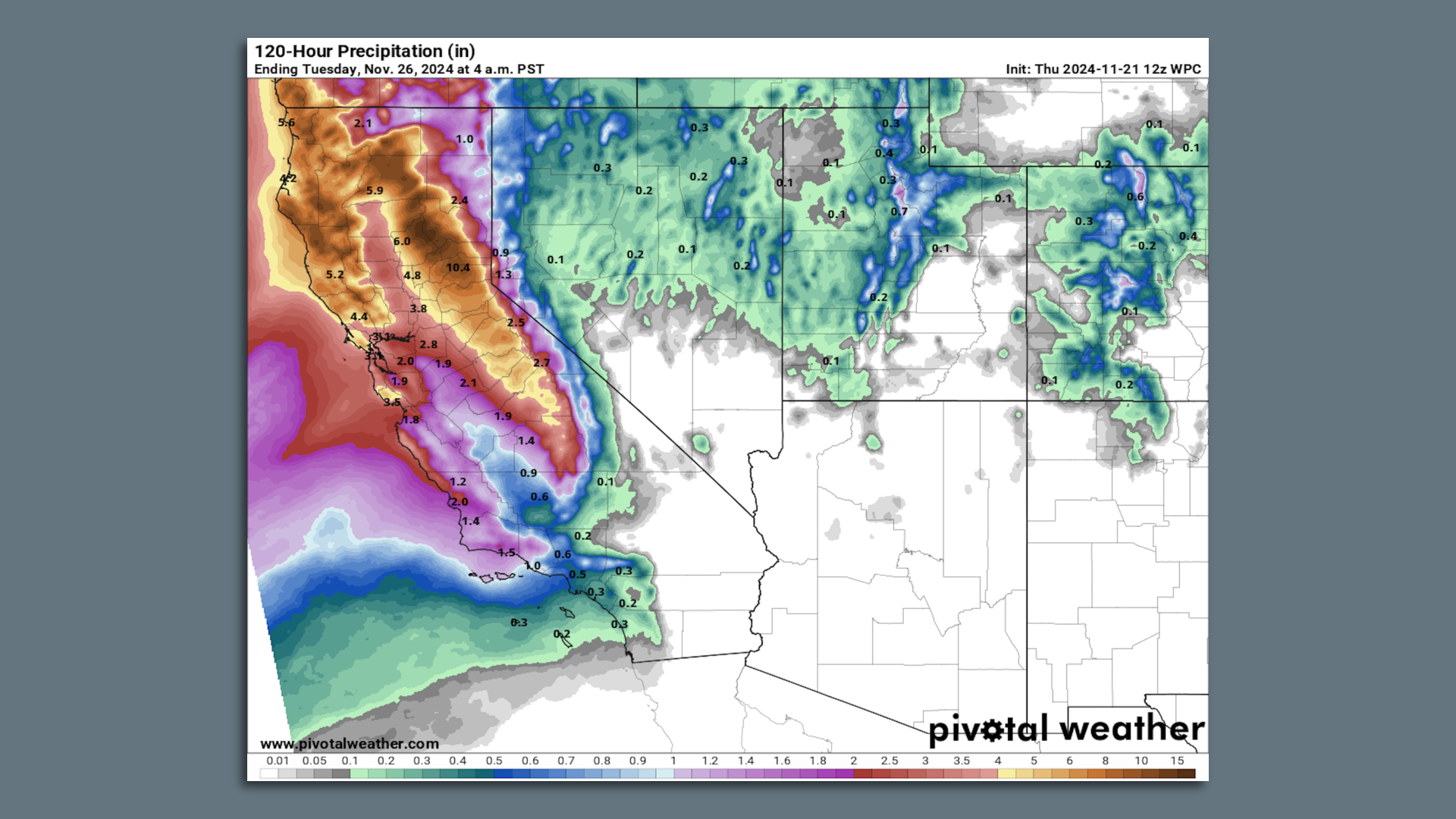
Map showing prediction additional precipitation totals in Calif. through Nov. 26. Image: Pivotal Weather
The West Coast is in the midst of a long-lasting heavy rain event tied to a bomb cyclone in the northeastern Pacific Ocean, with the National Weather Service warning of "life-threatening flooding" in Northern California.
Threat level: The rapidly intensifying storm that is directing a strong atmospheric river at southwestern Oregon and Northern California brought hurricane-force winds to parts of Oregon, Washington and Canada late Tuesday into early Wednesday, causing widespread power outages.
- At least one person has died.
- The National Weather Service issued a rare "high" likelihood of excessive rainfall on Thursday, which highlights the danger of more heavy rain on already saturated soils, particularly in Northern California.
- The agency is forecasting precipitation totals of 12 to 16 inches or more, and warns of rock and landslides in this region.
- "High risk" days are associated with a majority of all flood-related property losses in the Lower 48 states, and about two out of five flood-related fatalities, according to the NWS' Weather Prediction Center.
The forecast office in Eureka, California, noted that an atmospheric river producing very heavy rainfall would end up "parking itself" over northwestern California starting Tuesday night and continue potentially into the weekend.
- That's raising flooding concerns for urban areas as well as rivers and streams over time.
State of play: The latest computer model projections show rainfall amounts that could reach 15 to 20 inches, or even higher, along coastal areas, once the rainfall during multiple days is added up.
- The highest totals will be in elevated areas.
- Weather Service data shows the Washington cities of Sunrise (Rainier) and Enumclaw saw wind gusts of 77 mph, 74 mph, respectively Tuesday evening as the bomb cyclone rapidly intensified and made its closest approach to the region.
- A woman in her 50s died Tuesday evening after a "large tree fell on a homeless encampment" in Lynnwood, Washington, during heavy winds connected to the bomb cyclone, per a South County Fire Facebook post.
Forecasters warned of the arrival Thursday into Friday of a second intensifying low pressure area, which will pinwheel around the first bomb cyclone in an atmospheric interaction known as the Fujiwara Effect.
- The result of these storms will be periods of heavy rain and more high winds through Friday.
An estimated 330,000 customers remained without power in Washington Thursday morning due to downed trees and power lines from the first phase of the storm Tuesday and Wednesday.
- Thousands also lost electricity in parts of California and Oregon, and could do so again.
Zoom in: The original bomb cyclone is drifting well northwest of Washington State while slowly weakening.
- Additional low pressure systems, including a second rapidly intensifying storm, are forecast to pinwheel around it through the early part of this weekend
- The main low pressure area qualified as a bomb cyclone due to its rapid rate of intensification. In fact, it greatly exceeded the meteorological definition of the phenomenon known as "bombogenesis," when a low pressure area intensifies by at least 24 millibars in 24 hours.
- The storm intensified by more than 50 millibars in that same timespan. As a general rule, stronger storms have lower minimum central air pressures associated with them.
What we're watching: The impacts of the strong atmospheric river, which has been stuck in place since Wednesday night.
The big picture: The atmospheric river is located to the south of the bomb cyclone, and is carrying copious amounts of moisture from the subtropics into Northern California and parts of Oregon.
- As their name suggests, atmospheric rivers are corridors of concentrated water vapor located in the middle atmosphere, about 10,000 to 20,000 feet above the surface.
- This particular atmospheric river event is forecast to rate as a 4 out of 5 on the Scripps Institution of Oceanography's severity scale, which takes into account the potential for heavy rainfall.
Context: Human-caused climate change is causing atmospheric rivers to carry more moisture and making them capable of producing more rain and snow.
- One 2022 study found that atmospheric rivers that hit California in 2017 were up to 15% wetter due to human-caused climate change.
- Other recent studies show future atmospheric river events may heighten this trend.
- Warmer air and ocean temperatures add more water vapor to the atmosphere, which storms can ingest and wring out over land.
In California, atmospheric rivers have been responsible for some of the biggest flooding events on record, though this storm's heavy rain and mountain snow aren't expected to lead to a historic event.
Editor's note: This a breaking news story. Please check back for updates.
