AI, other new tools bolster tracking of deforestation

Add Axios as your preferred source to
see more of our stories on Google.
New technologies are providing unprecedented capabilities for combating deforestation around the globe, particularly in tropical forests.
Why it matters: The technologies, which are made possible by advances in Earth observing satellites and artificial intelligence techniques, are in the spotlight as global biodiversity treaty talks take place in Cali, Colombia.
- They are aimed at monitoring and providing actionable intelligence for governments, activists and nonprofits to protect the forests that act as major carbon sinks.
Zoom in: The newest developments come from the nonprofit forest carbon tracking group CTrees, as well as the satellite company Planet Labs PBC.
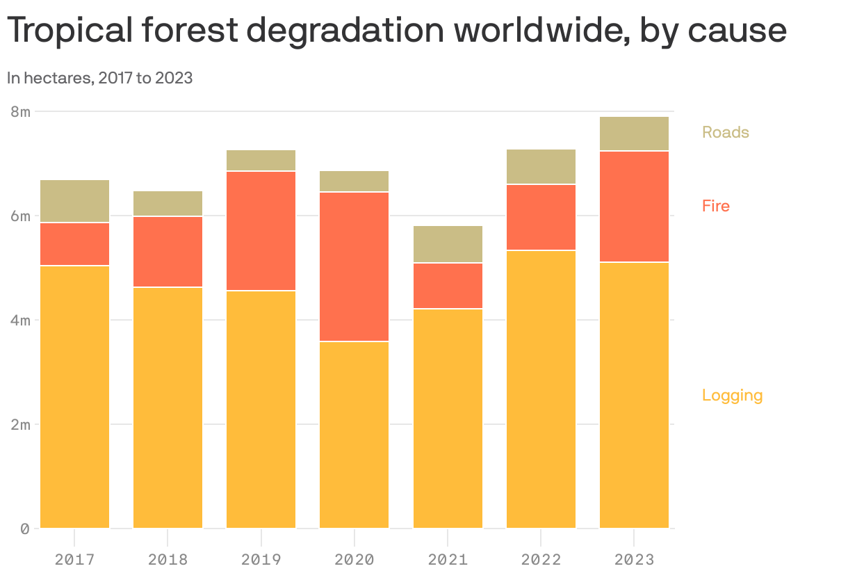
- CTrees built an AI-driven platform to monitor forest degradation, which refers to the loss of trees, carbon and other ecosystem benefits. These lands have not been clear-cut, however.
- Degradation can result from a variety of human activities ranging from logging to construction of roadways into intact forests, or development at the edges of tropical forests that chip away at the total area.
A report released Tuesday shows the result of what the organization bills as the first pan-tropic data pinning changes in forest landscapes to logging, fires (most of which are human-caused) and road construction, among other contributors.
- Prior monitoring relied on the long-running but lower resolution NASA and U.S. Geological Survey's Landsat imagery.
- But more detailed information for CTrees' product comes from the PlanetScope satellite constellation, which Planet Labs provides through Norway's International Climate and Forest Initiative.
The intrigue: In a sign of the tough work that delegates, nonprofit organizations and others have ahead of them in Cali and beyond, CTrees found that an average of 26,641 square miles of tropical forest are being degraded per year.
- That's equivalent to the size of Ireland, with a cumulative degraded area equal to nearly the size of California during the past six years.
- Brazil, Indonesia and Malaysia ranked as the top countries experiencing the most forest degradation during the past six years.
- But land degradation and deforestation isn't just a concern for tropical countries. That because of the vast carbon storage in the boreal forests that ring the Arctic, as well as shifts in the western United States' forest composition due to long-term climate change and its related hazards.
Zoom out: In a separate but related development last month, Planet Labs unveiled a new product that monitors forest carbon, tree height and tree cover to provide more precise measurements of forest carbon sinks.
- The product relies on machine-learning models that examine historical satellite observations as well as contemporary imagery, right down to near the level of individual trees.
- This data could be especially useful for ensuring that forest carbon credits — which many companies are already relying on in order to achieve sustainability targets — are measurable and verifiable.
Will Marshall, Planet's CEO, told Axios in an interview that the forest carbon product could help voluntary carbon markets scale up much faster and to greater heights.
- "We're still scratching the surface of the detection systems that we need," he said.
What they're saying: Marshall is bullish on AI's ability to glean new insights from large Earth observation data sets.
- "We've given ourselves some wicked problems with climate change and biodiversity loss, but we now have some wicked tools," he said.
Go deeper:
