Milton to remain "extremely dangerous hurricane through landfall" in Florida

Add Axios as your preferred source to
see more of our stories on Google.
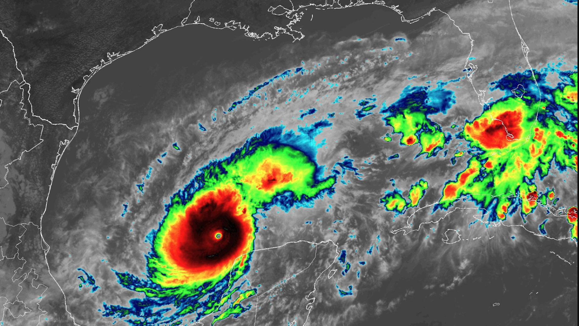
Infrared satellite image of Hurricane Milton at Category 5 intensity on Monday afternoon. Image: NOAA
Evacuations are under way in the Tampa Bay area and other parts of Florida's Gulf Coast as Hurricane Milton "explosively" intensified ahead of its approach to the state's Gulf Coast Wednesday.
Threat level: The storm poses a dire scenario of a potential direct hit on Tampa Bay from the west-southwest. That would push an unprecedented 10- to 15-foot storm surge into Tampa and other locations along and to the south of where the eye crosses the coast.
- For comparison, the peak surge in the Tampa Bay area during Hurricane Helene was at the high end of the range of 4 to 8 feet. It proved extremely damaging, and raised awareness about the city's overall surge risk exposure.
- Hurricane and storm surge warnings have been issued along the state's west coast.
- Michael Lowry, a hurricane specialist and storm surge expert at WPLG Local 10 in Miami, noted that Tampa Bay's storm surge forecast is the highest that the Hurricane Center has ever issued for that location.
A storm track just to the south of Tampa would spare the city from the worst surge impacts, but put other heavily populated areas at greater risk.
State of play: The storm started Monday with 90 mph maximum sustained winds. During a hurricane hunter flight, winds increased to 180 mph at 5pm ET.
- By 1am Tuesday ET, the winds had dropped to 155 mph — a high-end Category 4 storm.
- "While fluctuations in intensity are expected, Milton is forecast to remain an extremely dangerous hurricane through landfall in Florida," the NHC said.
- The storm is also expected to become larger throughout Tuesday and Wednesday, which will pile more water onshore.
For the record: Hurricane Milton became one of the most intense hurricanes on record in the Gulf of Mexico based on wind speed, and even the broader Atlantic Ocean using surface air pressure readings, according to Philip Klotzbach of Colorado State University.
- The storm has also intensified at one of the highest rates on record, according to forecasters at the Hurricane Center, and is the strongest storm so late in the season.
Zoom in: Florida is already seeing heavy rain unrelated to the hurricane, which will raise the risk of flooding once Milton arrives.
- The NHC is calling for a total amount of rainfall that may range from 5 to 10 inches across the state, with up to 15 inches in some areas.
- The urban flood risk includes Miami and Ft. Lauderdale as well as Orlando.
Stunning stat: The central pressure in Milton's eye fell to a "near record low" at 897mb, according to the NHC's 8pm advisory.
- "Based on this, Milton had the fifth lowest central pressure in the Atlantic basin hurricane record," according to the Hurricane Center.
The intrigue: Hurricane Milton comes less than two weeks after Hurricane Helene hit Florida's Big Bend region, sending a damaging storm surge into Tampa Bay and other parts of the state's northern and central Gulf Coast.
- The federal and state government may be stretched in responding so quickly to another destructive storm, particularly one that could knock out power to millions and flood thousands of homes and businesses.
- But the White House said: "FEMA has sufficient funding to both support the response to Hurricane Milton and continue to support the response to Hurricane Helene — including funding to support first responders and provide immediate assistance to disaster survivors."
Between the lines: Milton was expected to weaken somewhat through Wednesday, per the NHC.
- However, even with weaker winds, the storm will still contain the storm surge of a stronger storm.
- The storm intensified by 90 mph in 24 hours, which is extremely rare.
- The current forecast shows the storm weakening to a strong Category 3 storm at landfall.
Context: Hurricane Milton is yet another in a string of rapidly intensifying storms seen during the past several years. It is part of a trend in the Atlantic basin and other hurricane-prone regions that's tied in part to human-caused climate change.
- Ocean temperatures in the Gulf of Mexico are at near record-warm levels, also driven by human-caused climate change.
What they're saying: Even with weakening near landfall, the storm is likely to have historic impacts when it comes ashore on the Florida Gulf Coast on Wednesday.
- "The system is expected to be a large and powerful hurricane at landfall
in Florida, with life-threatening hazards at the coastline and well
inland," NHC said. - "Residents in Florida should closely follow the orders from their local emergency management officials, as Milton has the potential to be one of the most destructive hurricanes on record for west-central Florida."
The bottom line: The hurricane "poses an extremely serious threat to Florida," per the NHC.
Go deeper: Study reveals thousands of long-term deaths from hurricanes
Editor's note: This article has been updated with new details throughout.
