Why Hurricane Helene's large size, rapid intensification make it a threat

Add Axios as your preferred source to
see more of our stories on Google.
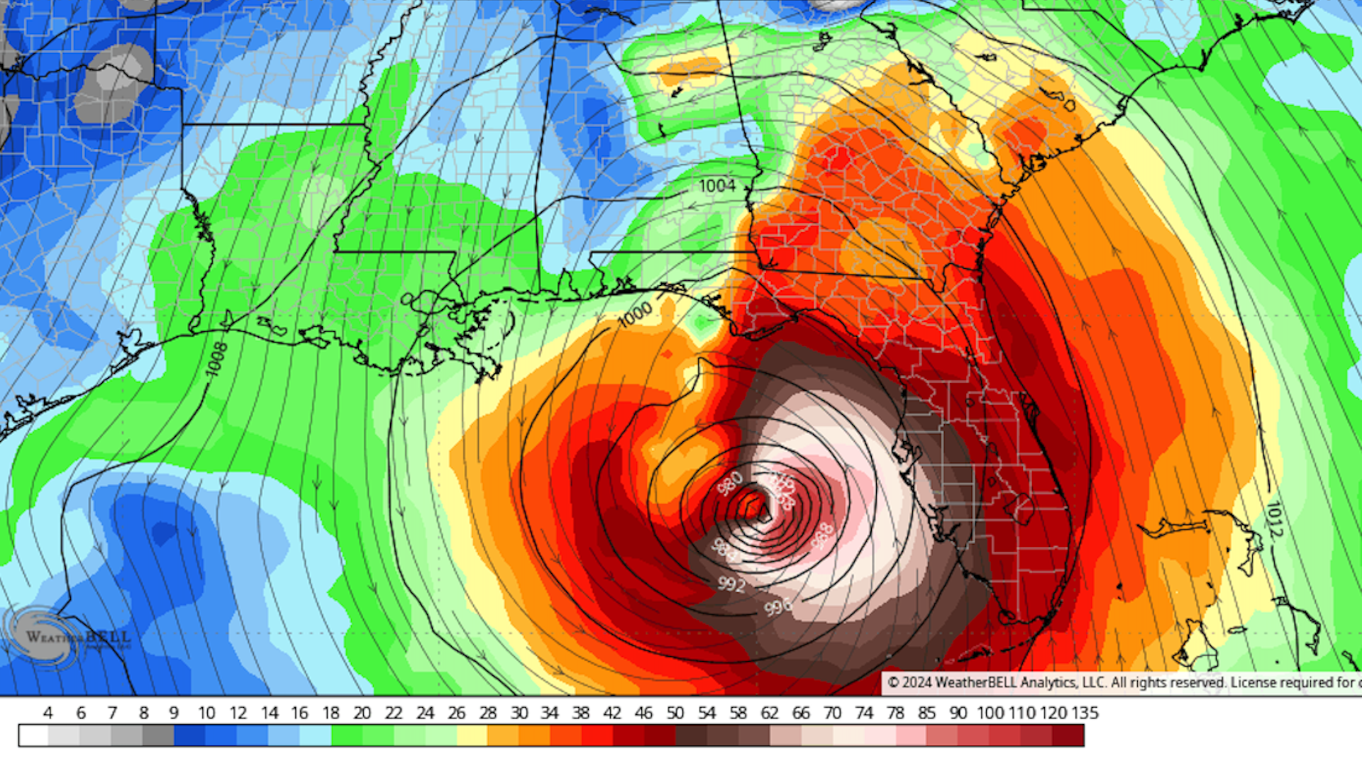
Computer model map showing projected wind speeds just above the surface on Sept. 26 from Hurricane Helene. Image: WeatherBell Analytics.
Hurricane Helene is growing unusually large for a Gulf of Mexico storm, and is now rapidly intensifying.
Why it matters: These two characteristics are making it a unique threat to millions of Floridians and people in surrounding states as it moves north-northeastward today and Thursday.
Threat level: The storm's large size, with tropical storm winds (sustained at 39mph to 73mph with higher gusts) extending at least 250 miles east of the storm center, ensures that nearly every Florida city outside the western Panhandle will see strong winds.
- In fact, power outages could stretch from scattered areas in southeastern Florida — and possibly even the Florida Keys — all the way into Georgia and parts of South Carolina.
- This would make for challenging post-storm cleanup operations. Utilities and FEMA typically stage equipment for storm recovery, and plan to move into narrower damage paths once the event is over, but this will be a multi-state damage footprint.
- Twenty of Florida's counties are under voluntary or mandatory evacuation orders as of Wednesday morning, according to the state's Division of Emergency Management. Much of the Tampa Bay and Sarasota regions are undertaking evacuations.
- Of its 67 counties, 61 are under states of emergency.
- According to Miami TV meteorologist Michael Lowry, Helene is forecast to be one of the five largest storms on record in the Gulf of Mexico in terms of its wind field.
Power outages are also likely to be widespread in Georgia and parts of South Carolina, as the storm may still be a hurricane when it moves into southern and south-central Georgia on Friday.
- Metro Atlanta is likely to see strong, damaging winds along with up to a foot of rain from Helene.
Zoom in: Storms that have large wind fields can push more water close to the coast and produce a larger, more damaging storm surge. This was seen most clearly with Hurricane Ike in Texas in 2008.
The intrigue: Computer models show the storm will intensify dramatically as it makes its way north-northeastward toward an expected landfall as a "major" Category 3 storm — or possibly stronger — on Thursday evening.
- The extreme intensification rate is due in large part to record-hot ocean surface temperatures and a deep reservoir of heat beneath the surface of the Gulf of Mexico.
- Such waters will serve as rocket fuel for the storm's winds to increase, especially when combined with a favorable environment in the atmosphere.
- The record warm ocean temperatures are no accident, either. Climate change is causing global ocean temperatures to spike, and they were at record-high levels for more than a year straight.
- According to data from the nonprofit research group Climate Central, human-caused climate change made the current record-warm waters of the Gulf of Mexico between 200 to 500 times more likely.
Between the lines: In fact, the Hurricane Center's forecast intensification rate on Monday morning was the highest it had issued to date when going from a pre-named system to a major hurricane.
- As of 5am ET on Wednesday, the NHC was still predicting a textbook case of rapid intensification, with maximum sustained winds strengthening from 70 mph on Wednesday morning to 120 mph on Thursday.
- There has been a documented trend toward more storms that rapidly intensify, and an amplification of the intensification rates in the Atlantic as well.
- Rapid intensification can catch coastal residents off guard, as they prepare for one storm category yet end up being affected by a far stronger hurricane.
The bottom line: The storm's size and intensification rate will require most, if not all, storm preparations to be made across Florida today, with residents of Georgia having slightly more time.
