"Record" heat envelops millions from Midwest to D.C.

Add Axios as your preferred source to
see more of our stories on Google.
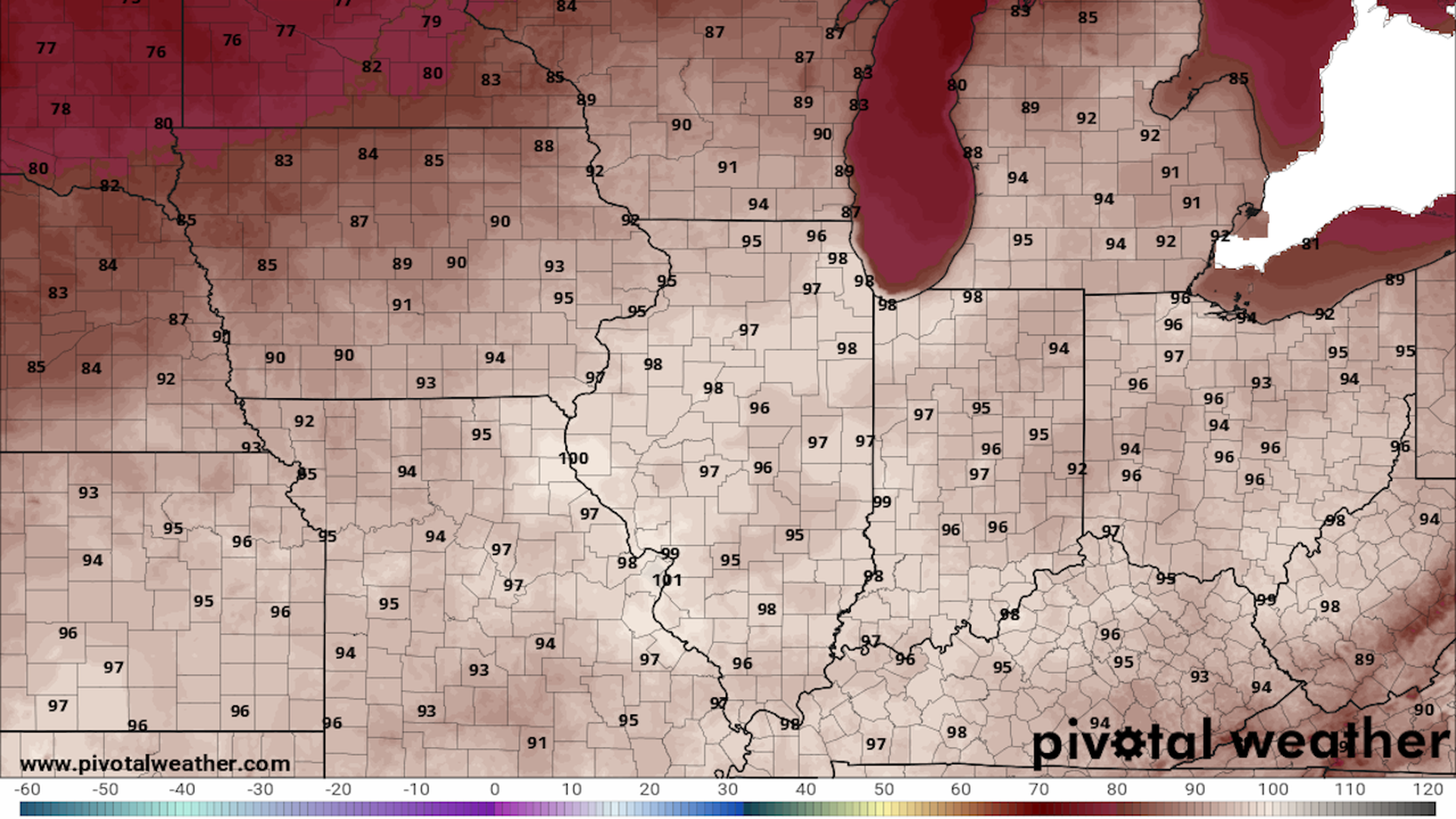
Map showing NWS forecast high temperatures in the Midwest on Tuesday, including 98°F in Chicago. Image: Pivotal Weather
The hottest weather of the summer is likely Tuesday in Chicago, with a widespread area of sizzling conditions from the Midwest to the Mid-Atlantic.
Threat level: The unusually hot air mass for late August already smashed records in the Southern Plains, and is focused on the Midwest, Ohio and Tennessee Valleys before shifting Southeast, breaking historical benchmarks.
- About 61 million people are under heat watches and warnings as highs near 100°F, combined with high humidity, lead to dangerous heat indices between 105°F and 115°F.
- PJM Interconnection, a power grid serving Delaware, Illinois, Indiana, Kentucky, Maryland, Michigan, New Jersey, North Carolina, Ohio, Pennsylvania, Tennessee, Virginia, West Virginia and the District of Columbia, issued a maximum generation alert for Tuesday due to the hot weather, warning that conditions could require "all generators to operate at their maximum output capability."
- According to the National Weather Service, the heat risk will reach "extreme" levels from St. Louis to Chicago, northeast to Grand Rapids, Michigan on Tuesday.
- This risk level applies to "anyone without effective cooling and/or adequate hydration," the NWS states, with likely effects to "Most health systems, heat-sensitive industries and infrastructure." At least 11 states are projected to see at least "major" levels of heat risk.
- Such extreme heat can quickly cause heat illness for even the healthiest of individuals, particularly anyone working or exercising outside.
Zoom in: As a weak cold front advances southeast from Canada, the core of the hot air and greatest heat risk is forecast to shift to the southeast through Wednesday, with a high temperature near 100°F in Washington, D.C..
- The National Weather Service forecast office in Chicago is warning of "near record warmth" on Tuesday, with an excessive heat warning in effect for the city.
- The agency is forecasting a high temperature of 98°F in Chicago on Tuesday, which is about 20°F above average for the date. The high temperature in St. Louis is forecast to reach 102°F on Tuesday, and may not fall below 90°F until Saturday.
- By Wednesday and Thursday, the area of hottest temperatures is likely to shift slightly south and east, focusing from roughly St. Louis to Washington, with July-like temperatures and humidity levels creeping up the Mid-Atlantic coast.
Between the lines: Public schools are going back into session or have already started for many cities, shining a spotlight on a lack of air conditioning in some school districts.
- Chicago Public Schools started Monday with heat restrictions in place.
- Typically, heat waves this severe in the Midwest are confined to July into early August, but human-caused climate change has been lengthening the heat season across many parts of the U.S.
- Climate change is also intensifying individual heat waves and raising their likelihood.
- Underscoring the health threat the heat wave poses, this round of scorching temperatures comes amid news that heat deaths in the U.S. last year reached 2,325 people. This was a peak since at least 1999.
Context: The heat is associated with a strong area of high pressure aloft, also referred to as a heat dome, that is slowly migrating from region to region, bringing scorching temperatures to areas under its influence.
- Along the heat dome's periphery, rounds of severe thunderstorms are likely Tuesday through Wednesday, in what meteorologists refer to as a "ring of fire" weather pattern. Such storms knocked out power to thousands in the Twin Cities Monday night, for example.
- The source air mass has already crushed heat records from Texas into the Central Plains.
- Abilene, Texas, hit its hottest temperature on record, at 113°F, on Aug. 21, as records fell elsewhere across the state as well.
- Amarillo, Texas also saw its hottest August temperature, at 108°F, and saw its longest streak of consecutive 100-degree days or above at 10 days.
The bottom line: This heat wave will not be record-setting in terms of duration, but it may tie or break numerous daily and possibly even a few monthly records.
Editor's note: The story is updated with a notice from the PJM Interconnection.
