June heat wave: How hot cities are expected to get


Add Axios as your preferred source to
see more of our stories on Google.
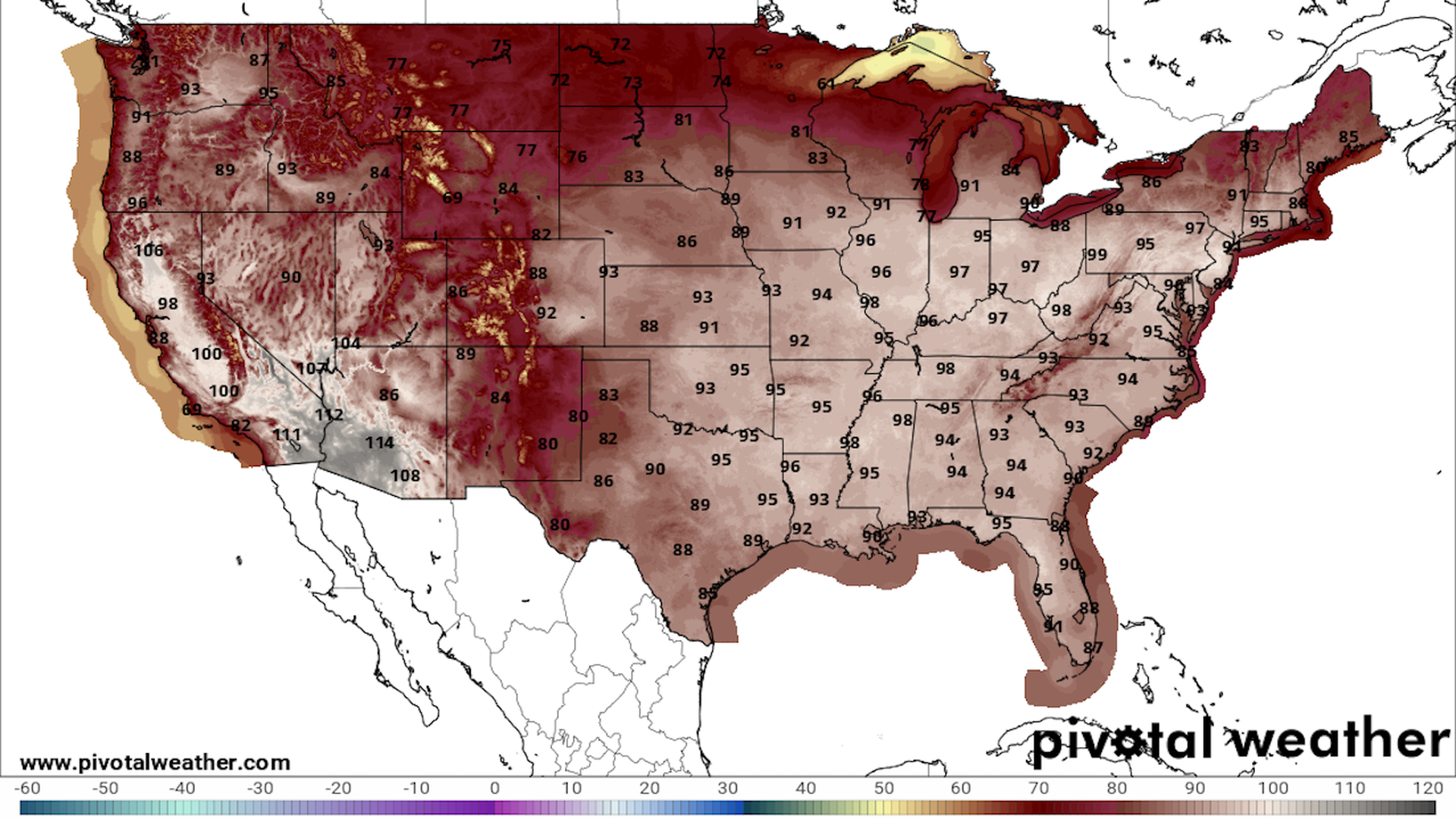
Map showing maximum air temperatures forecast for June 21 across the Lower 48 states. Image: Pivotal Weather.
A near record strong heat dome has enveloped the Midwest, Mid-Atlantic and Northeast. It is poised to bring record-breaking high temperatures and sultry, uncomfortable nights during the next two weeks, according to the National Weather Service (NWS).
Why it matters: Prolonged, scorching temperatures increase the risk of heat illnesses or death among the millions of people who must face them.
Threat level: Multiple cities are likely to see spikes in heat-related illnesses, which target those without access to cooling as well as the very young, elderly and people with certain chronic illnesses.
- A key indicator of the threat from this heat event is the elevated overnight lows, which could set dozens of records.
The big picture: The heat will peak this weekend in many of the cities most affected, but that will not be the end of the story.
- The heat dome will weaken slightly and elongate into a mid-summer-like pattern, except at the very start of the calendar season.
- Here's how the heat is likely to play out in some of the most affected locations:
Chicago: Daytime highs are set range between the upper 80s and 90s before peaking at 96 degrees Fahrenheit on Saturday, according to NWS forecasts.
- Nighttime lows will also remain in the upper 60s and lower 70s for the remainder of the week.
- NWS' long-term computer models show highs between the upper 80s and 90s until at least June 28.
St. Louis: Daily highs are expected to peak at 99°F on Saturday before ticking down to 95°F on Sunday and Monday.
- Lows over that period are not expected to dip below 73°F.
- Long-term models show the 90°F highs and above, and 70°F lows or greater until at least June 28.
Detroit: The city is set to see 90°F or greater highs over the next three days with a peak of 93°F on Wednesday.
- After that streak ends, temperatures are set to drop slightly to the upper 80s later this week and early next week.
- Over the long term, highs in the mid- to low-80s°F should continue into next week, as the city benefits from cooler air from Canada.
Columbus: Highs could jump above 90°F and lows above 74°F for the rest of the week, with a peak of 98°F on Saturday.
- Temperatures are projected to remain in the upper 80s°F and low 90s°F next week.
Cleveland: After Tuesday's high of 94°F, the NWS forecasts daily highs to remain in the upper 90s°F for another five days.
- Lows over that period are forecast to stay at or above 70°F.
- Model projections show highs cooling into the 80s°F throughout next week.
New York City: Highs are set to build to the lower 90s°F over the next three days before slightly dropping to the upper 80s°F on Saturday.
- Model simulations show highs remaining in the high 80s°F to low 90s°F next week.
Albany: After Wednesday and Thursday's expected peaks of 96°F, the heat may only slightly abate to the upper 80s°F for the remainder of the week, with elevated overnight lows.
- Long-term, highs in the upper 80s°F and 90s°F should continue into late next week.
Burlington, Vt.: Highs could remain above 90°F over the next three days before cooling to the low 80s for the remainder of the week.
- Those three days may be hottest three-day stretch in 30 years for some in the area, the NWS said.
Boston: Starting Tuesday, Boston could also see a three-day stretch of 90-degree-plus highs, along with upper 90°F heat indices and 70°F or greater lows
- Boston should then cool down, courtesy of a cold front swinging down from the north.
Philadelphia: The city is set to see high temperatures of 90°F or higher through June 24, according to the NWS forecast, with an expected peak of 99°F on Friday.
- That would tie a record set in 1923, according to the NWS.
- Over the longer term, computer models show highs remaining above 90°F, with lows above 67°F through June 27.
Pittsburgh: Its heat streak may not be as long as Philadelphia's, but the city is expected to see highs above 90°F and lows above 70°F for at least five days starting Tuesday.
- The NWS said a six-day run of lows that warm has never been recorded in the month of June.
Washington, D.C.: The heat should peak in D.C. over the weekend, with highs between 97°F and 99°F on Saturday and Sunday.
- Longer-range models show temperatures continuing in the 90s through next week, potentially all the way until the end of June.
- This could wind up as one of the longest streaks of 90-degree days on record for any time of year in D.C..
What they're saying: The temperatures may not stand out as particularly eye-catching, but other factors make this heat wave especially problematic.
- "The early arrival of this magnitude of heat, the duration, abundant sunshine, and lack of relief overnight will increase the danger of this heatwave beyond what the exact temperature values would suggest," the NWS stated Tuesday.
Go deeper:
