How Hurricane Otis shocked forecasters in a "nightmare scenario"

Add Axios as your preferred source to
see more of our stories on Google.
Hurricane Otis' extremely rapid intensification — so close to the Mexican coast — was one of the biggest, most high-stakes hurricane forecasting failures in years.
The big picture: The storm's leap from a tropical storm on early Tuesday to a Category 5 storm near midnight highlighted what climate change, combined with weather and climate variability, can do to a storm if conditions are right.
- They also showed a rarely seen weakness in modern weather forecasting: a completely unforeseen transformation of a tropical cyclone within 24 hours of landfall. NHC forecasters termed the event a "nightmare scenario."
- In this age of computer models, sail drones, crewed hurricane hunters and 5-day forecasts, many people are not accustomed to a forecast bust like this one.
- "You know, we were expecting a hurricane, but it's a big difference between a hurricane and a Category Four or Five hurricane in terms of impacts," Mike Brennan, the director of the National Hurricane Center, told Axios in an interview.
- "That's the challenging situation you run into when you have a major metropolitan area being affected by a storm, where the expectations about the impacts change dramatically in the last few hours before landfall."
Zoom in: Hurricane Otis' dramatic strengthening defied the projections of nearly all operational computer models, as well as NHC's experts.
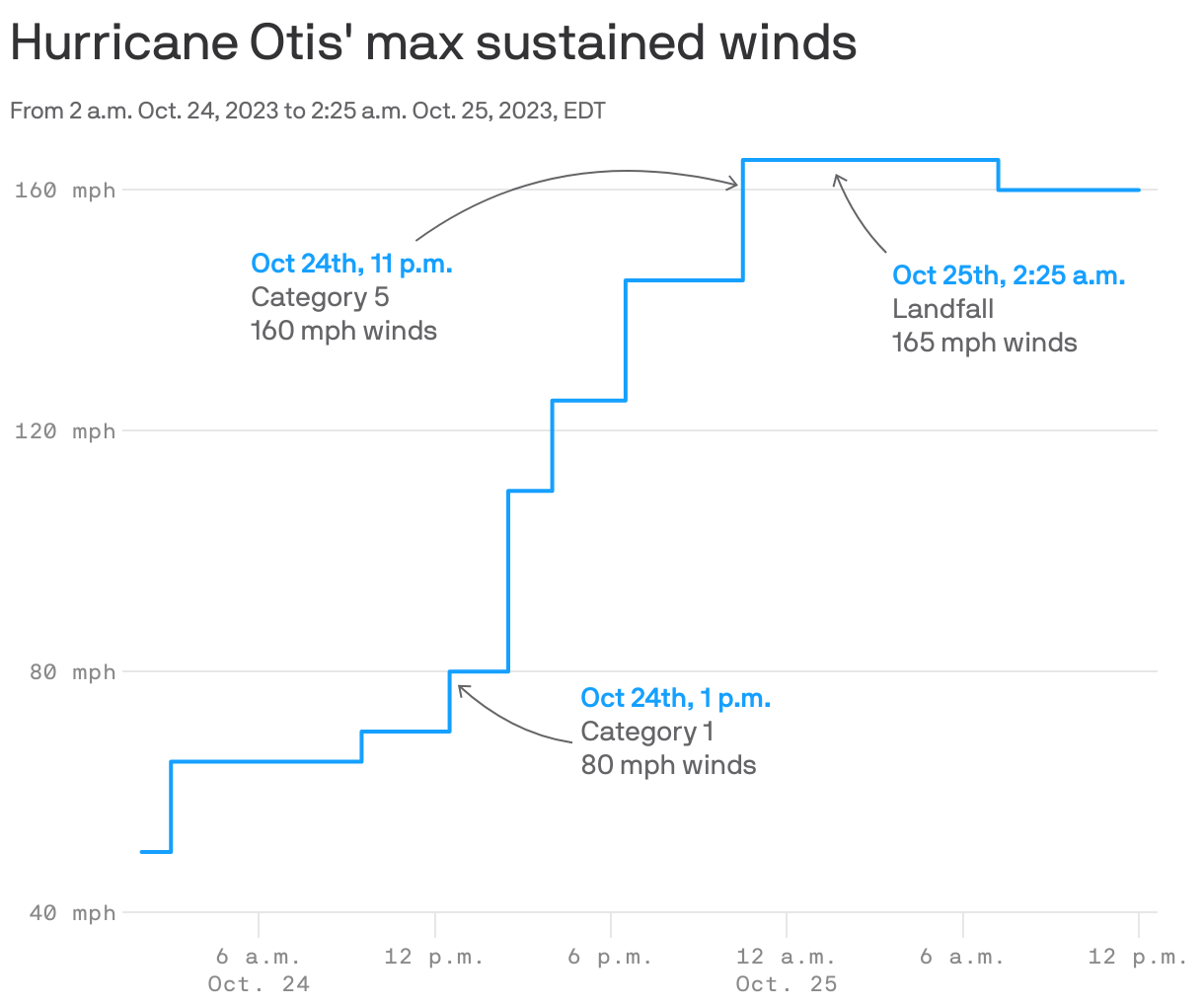
- The storm's winds cranked up by an astonishing 110 miles per hour in 24 hours, and 80 mph in just 12 hours.
- This intensification rate is only exceeded in modern times by Hurricane Patricia in 2015, per NHC.
- It remained a powerful Category 5 through landfall early Wednesday, roaring ashore with maximum sustained winds of 165 mph.
- It is now the most intense hurricane on record to make landfall along Mexico's Pacific coast, and possibly anywhere in Mexico.
Between the lines: Studies show that hurricanes are upgrading faster, and more frequently, in many parts of the world, enabled mainly by warmer ocean waters.
- Human-caused climate change is the main driver of those ocean temperature trends, experts say.
- One study published last week found that in the North Atlantic Ocean Basin, tropical cyclones are intensifying faster and more rapidly than they used to, more than doubling in the number of such storms going from a Category 1 storm, or weaker to a Category 3, or higher in just 36 hours.
- It attributed these trends to human-caused climate change.
- Globally, oceans have been at their hottest levels on record for months, including parts of the eastern Pacific Ocean, where the heat is in part due to a strong El Niño event. Otis traversed an area of unusually warm waters as its intensity exploded.
The intrigue: Experts told Axios that, along with climate change, other elements probably helped this storm to transform itself from a relatively benign threat to a monstrous hurricane.
- According to Karthik Balaguru, of the Pacific Northwest National Laboratory, in the region where Otis intensified, warm waters extended to deep depths, which favors intensification.
- In addition, the waters were unusually fresh near the surface, which inhibits water layers from mixing, which could otherwise draw up somewhat cooler waters from below.
- Balaguru has published studies on the influence of salinity on intensification rates. One such study found that low salinity surface waters played a major role in helping Hurricane Patricia to become the strongest hurricane in the western hemisphere in 2015, with maximum sustained winds of 215 mph.
- "Similar processes could likely be at work here, but we can only confirm this after a detailed analysis," he told Axios via email.
What they're saying: Researchers say climate-related trends in rapidly intensifying storms are not yet as clear in the Eastern Pacific as they are in other parts of the world. That's partly because powerful storms are especially common there.
Of note: Other factors, such as a favorable upper air flow, allowed Hurricane Otis to rapidly intensify without weakening near landfall.
The bottom line: What scientific research lacks, so far, is a firm explanation for why Otis got so strong so fast.
- For now, Brennan's team at NHC is reeling, given their mission of protecting lives and property, he said. "Every one of these events takes a toll and you take a piece of it with you going forward," he said.
