Death toll rises to 16 from "most-devastating" flooding in eastern Kentucky

Add Axios as your preferred source to
see more of our stories on Google.
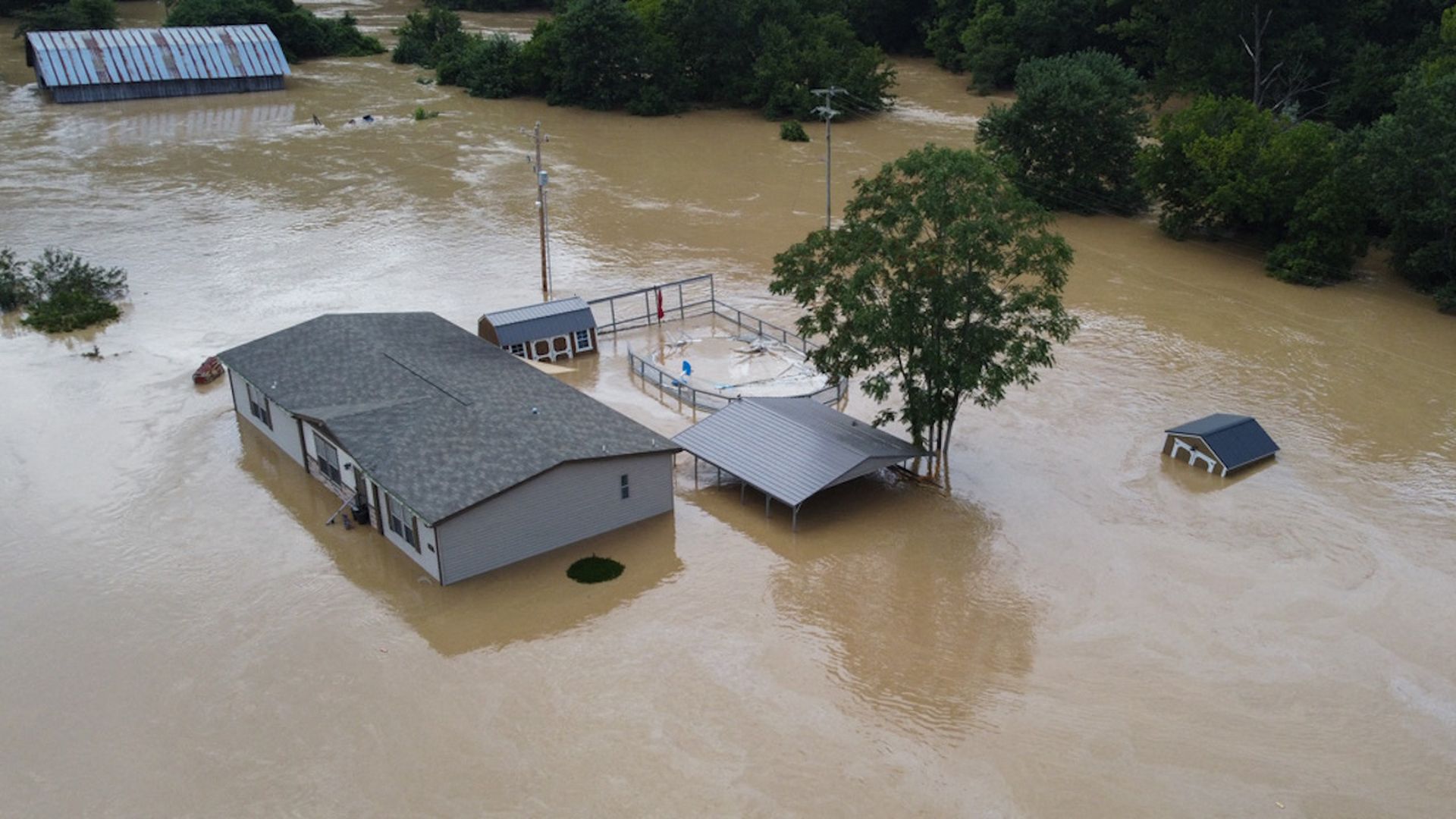
Homes submerged under flood waters from the North Fork of the Kentucky River. Photo: LEANDRO LOZADA/AFP via Getty Images)
Gov. Andy Beshear said Kentucky has experienced "one of the worst, most-devastating flooding events" in its history after heavy rainfall and flash flooding hit the eastern portion of the state overnight Wednesday into Thursday morning.
The big picture: This is the second deadly extreme rainfall event from this same frontal system, which stuck the St. Louis metropolitan area with record rainfall on Tuesday, also causing flash flooding that killed at least one person.
The latest: Beshear said Friday that 16 people have died in the flooding, adding that he expects that number to rise.
- "It's been a hard couple of days," he told CNN. "Hundreds of people lost everything, most of them didn't have much to start with."
- Beshear declared a state of emergency and activated the Kentucky National Guard, which mobilized and has begun to respond to the region.
- Kentucky State Police and its Department of Fish and Wildlife are also actively searching for missing people.
- Images shared on social media showed houses and roads submerged and cars swept away by flood waters.
- West Virginia and Tennessee are sending Kentucky additional aircraft to support search and rescue efforts, Maj. Gen. Hal Lamberton of the Kentucky National Guard said.
What they're saying: "Unfortunately, I expect double-digit deaths in this flooding," the governor said.
- “What we’re going to see coming out of this is massive property damage,” the governor said at another news conference earlier Thursday morning.
- “We expect a loss of life. Hundreds will lose their homes, and this is going to be yet another event that it’s going to take not months but likely years for many families to rebuild and recover from," he added.
By the numbers: The town of Hazard, Kentucky, had received an estimated 8.55 inches of rainfall in 12 hours as of 7 a.m. Thursday, according to the National Weather Service (NWS).
- Alex Lamers, a meteorologist for the NWS, tweeted Thursday that that amount "is more than double (!) the 1-in-100 average annual chance threshold, and a couple inches beyond even the 1-in-1000 threshold."
- Buckhorn had received 8 inches as of 7 a.m. Thursday, and Oneida was hit by 7.20 inches as of 8 a.m. Thursday.
- Kentucky's 24-hour rainfall record is 10.48 inches, which was observed in Louisville in 1997.
- At least 25,111 households were without power Thursday, according to Beshear.
There may still be more heavy rain events through Friday, NOAA warns. Flood warnings and advisories were extended through Friday for eastern Kentucky, as thunderstorms are expected to return overnight with additional rainfall, according to the NWS.
- Most of eastern Kentucky, including the towns of Jackson, London and Lexington face a moderate risk of excessive rainfall causing additional flooding overnight.
- Extreme rainfall events like this one are becoming more common and intense due to human-caused global warming.
Go deeper: Hundreds of temperature records broken as heat wave scorches the U.S.
Axios' Andrew Freedman contributed to this story.
Editor's note: This story will be updated as more details become available.
