Hurricane Michael rapidly intensifies, heads toward Florida

Add Axios as your preferred source to
see more of our stories on Google.
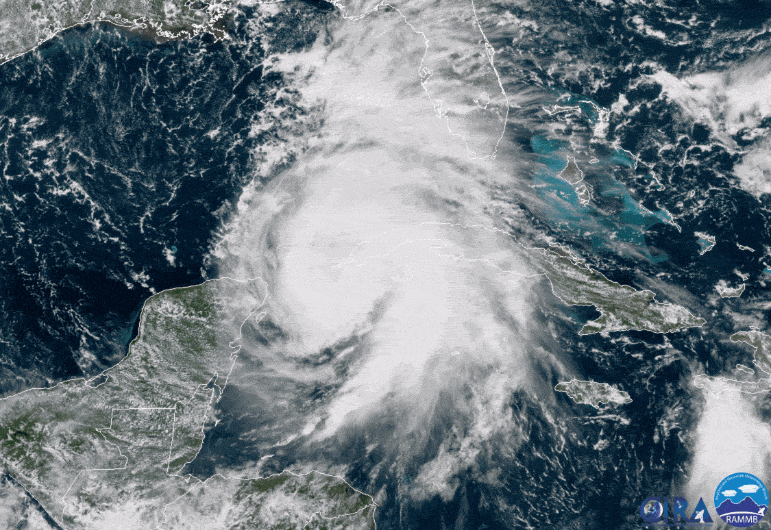
Hurricane Michael rapidly intensified on Sunday and Monday between Mexico's Yucatan Peninsula and Cuba, and is headed for Florida's Big Bend region — likely coming ashore between Destin and Apalachicola on Wednesday — as a major Category 3 or 4 storm. Hurricane and storm surge warnings are now in effect for parts of Florida, with watches extending west into Alabama.
Why it matters: This storm presents a particularly dangerous situation for the Sunshine State, since computer models and official forecasts have trended toward a stronger hurricane. The storm's track means residents will have only a few days at most to prepare, and some may be caught unaware after a long holiday weekend.
Tropical-storm-force winds of greater than 39 miles per hour will begin to overspread the Florida Panhandle on Tuesday, and storm surge flooding will begin well ahead of the storm's actual landfall, potentially cutting off coastal escape routes.
Between the lines: Hurricane Michael has defied a moderate amount of wind shear, which is when winds blow at different speeds and/or direction with height. Such shear typically prevents such storms from quickly intensifying, but the National Hurricane Center now says it has not and will not impede this particular storm.
Threat level: Model projections now show declining shear as the storm moves closer to Florida during the next two to three days, allowing for even greater strengthening.
- Most reliable computer models show Hurricane Michael will make landfall near Destin, Florida sometime between Wednesday afternoon and early Thursday, as a major hurricane of Category 3 intensity or greater.
- The Florida coast between Apalachicola and Cedar Key is susceptible to extremely high storm surge events due to the shape of the coastline. However, the exact storm surge amounts will depend on storm intensity at landfall, the timing of high tide and the structure of the hurricane.
- Currently, the Hurricane Center is predicting a maximum of 8 to 12 feet of water above normally dry ground from Indian Pass, Florida to Cedar Key, if the maximum surge hits at high tide. It's also forecasting 6 to 8 feet of water above normally dry land from Cedar Key to Crystal River, Florida under the same conditions.
- Hurricane Michael has the potential to cause widespread, devastating damage from storm surge flooding and strong winds. The wind damage could progress far inland, even into Georgia.
- This storm could present a particularly dire scenario for the city of Tallahassee, Florida, with strong winds as the primary threat there.
The bottom line: Should Hurricane Michael make landfall as a Category 3 or 4 storm this week, it would be the first "major" hurricane to strike the U.S. this hurricane season, since Hurricane Florence weakened prior to landfall. More importantly, it would be one of the most intense hurricanes on record to strike this part of Florida.
Unlike Florence, it is not expected to stall after hitting land, but is instead likely to roar onshore and move northeastward into Georgia and the Carolinas.
