Updates: Hurricane Lane drenches Hawaii as winds fizzle

Add Axios as your preferred source to
see more of our stories on Google.
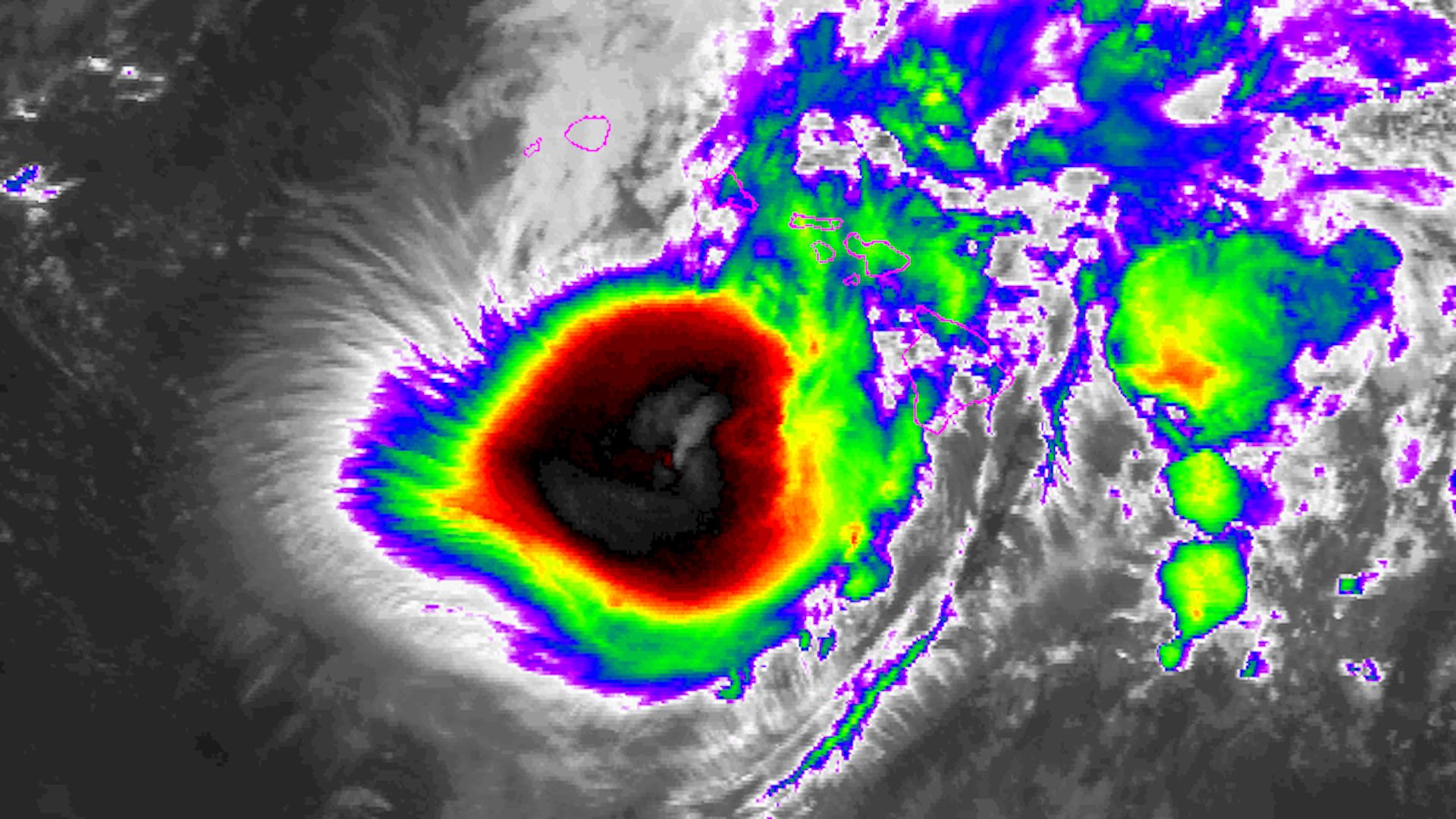
Infrared satellite image of Hurricane Lane approaching Hawaii on Aug. 24, 2018. Photo: NOAA.
Editor's note: We have finished live updates for Friday, August 24, and our coverage will resume on Saturday. Scroll down for the most recent updates.
Hurricane Lane is drifting towards what may be Maui and Oahu's closest encounter with a significant hurricane since statehood in 1959. The storm remains a Category 3 hurricane on the Saffir-Simpson Scale, and is causing "catastrophic" flooding on the Big Island, where more than 30 inches of rain have already fallen.
The big picture: The storm is creeping northward at just 5 miles per hour, prolonging the wind and flooding threats for the Hawaiian Islands. And even though the storm is just 24 hours away from its closest pass with Maui and Oahu, where Honolulu could see hurricane force winds for hours on end, the exact track is still murky.
The details: Hurricane Lane is contending with dueling influences — warm ocean waters, which tend to maintain the storm's intensity, and increasing amounts of wind shear out of the Southwest, which are weakening the storm. Which factor wins out will make a big difference in determining the movement and rate at which the storm's winds slacken over time.
- However, the biggest danger with this storm has been, and will continue to be, water. According to the National Weather Service, "catastrophic flooding" is occurring on the Big Island of Hawaii, where a persistent flow of moisture from the Southeast is running up against the island's 10,000-foot-high peaks, wringing out torrential rains.
What we're watching: As weather.com notes, no hurricane has come within 65 nautical miles of Maui and Oahu in decades. The storm's slow movement means the islands will be on the right quadrant of the storm, where the strongest winds and heaviest rains are located. This presents a significant threat of damage from flooding and high winds.
Even if the center of the storm stays at sea, Hawaii could see one of its worst storms on record. Here are two of the most important messages from the Central Pacific Hurricane Center in Honolulu:
"It is vital that you do not focus on the exact forecast track or intensity of Lane, and remain prepared for adjustments to the forecast. Although the official forecast does not explicitly indicate Lane's center making landfall over any of the islands, this remains a very real possibility. Even if the center of Lane remains offshore, severe impacts could still be realized as they extend well away from the center.
Lane will pass dangerously close to the main Hawaiian Islands as a hurricane on Friday, and is expected to bring damaging winds. Terrain effects can cause strong localized acceleration of the wind through gaps and where winds blow downslope. These acceleration areas will shift with time as Lane passes near or over the islands. Winds will also be stronger at the upper floors of high rise buildings."— Central Pacific Hurricane Center
Updates
8:25 p.m. ET: Hurricane Lane has undergone a period of astonishingly rapid weakening, with its satellite and radar presentation showing the complete disintegration of its core of once-fearsome thunderstorms. The storm, currently a Category 1 hurricane, will soon be downgraded to a tropical storm, and eventually a tropical depression over the weekend.
This was the best case scenario, and frankly, a low probability outcome for the Hawaiian Islands, given how strong the storm was even as of Friday morning eastern time and the divergence of computer model guidance. Instead of facing hours of hurricane force winds and a foot or more of rain, Honolulu will experienced periods of gusty showers for the next few days.
Flooding continues in some parts of the islands, particularly on the Big Island, and some areas will still see very heavy rainfall rates. Overall though, this storm has practically evaporated into thin air, sparing the most populated areas and the region with the most critical infrastructure.
For a technical explanation of how this all went down, follow this Twitter thread by meteorologist Philippe Pappin, who explains the "decoupling" of the storm's mid-level center from its surface circulation.
There's also this note from The Weather Channel's Greg Postel.
5:24 p.m. ET: The National Weather Service issued the following update: "One should not interpret the forecast westward turn south of the islands as a lower threat to the islands. If Lane retains central core convection longer than anticipated, the westward turn would happen later, which could bring hurricane conditions to Maui County or Oahu. This solution is still plausible at this time. Regardless of whether Lane makes landfall, severe impacts are still possible and the effects can extend far to the north and east of the center of Lane."
"Lane will remain dangerously close to the central Hawaiian Islands as a hurricane today into tonight bringing damaging winds to some areas. Terrain effects can cause strong localized acceleration of the wind through gaps and where winds blow downslope. These acceleration areas will shift with time as Lane passes near or over the islands. Winds will also be stronger at the upper floors of high rise buildings."
"The slow movement of Lane greatly increases the threat for prolonged heavy rainfall. This is expected to lead to major flash flooding and landslides in some areas."
5:00 p.m. ET: Hurricane Lane is moving again, at least a bit, to the north at 5 miles per hour, as of 11 am local time in Hawaii. Maximum sustained winds remain at 105 miles per hour.
A reminder not to focus on a storm's category or top winds for clues about its main impacts, from meteorologist Marshall Shepherd.
4:25 p.m. ET: Forecast note: The main computer models used to predict hurricanes (and other storms) show that Hurricane Lane will continue to drift slightly north while weakening for about the next 18 to 24 hours, virtually assuring staggering rainfall totals on the Big Island and portions of Maui and Oahu. However, the storm will become weak enough, according to such projections, to get pulled westward by low-level trade winds, preventing it from getting close enough to Honolulu to be a major wind threat.
These model projections are just that — projections — but they are all pointing in the same direction, and make sense given the physics of such storms.
3:30 p.m. ET: This is a rare sight, a satellite capturing a hurricane and a wildfire at the same time, both in Hawaii of all places. Here it is, from NOAA:
3:02 p.m. ET: Hurricane Lane continues to slowly weaken as its once formidable eyewall, where the most intense winds are found, unravels. According to the Central Pacific Hurricane Center:
- Lane had maximum sustained winds of 105 mph as of 8 am local time, or 2 pm eastern. The storm has also slowed to a virtual standstill, moving north at just 2 miles per hour. The center of the storm is located about 170 miles due south of Honolulu.
- The slow movement means high winds are unlikely to come roaring ashore in Oahu during the morning, but that heavy rains will continue to fall across the island chain, elevating the flood threat.
- More than 30 inches of rain have fallen on the Big Island, with heavy rain now engulfing Maui and Oahu as well.
1:53 p.m. ET: An area of very heavy rain is headed toward Honolulu as the hurricane slowly churns northward toward Oahu. Conditions will deteriorate quickly once this moves onshore.
12:42 p.m. ET: Hurricane Lane has weakened to a Category 2 storm, with maximum sustained winds down to 110 miles per hour. This weakening was expected, and is forecast to continue. However, it's likely that Lane will remain a hurricane during its closest pass to Honolulu and the island of Maui.
This is how the NWS describes the flood threat for all of the Hawaiian islands, given the storm's slow movement: "The slow movement of Lane also greatly increases the threat for prolonged heavy rainfall and extreme rainfall totals. This is expected to lead to catastrophic, life-threatening flash flooding and landslides over all Hawaiian Islands."
A wildfire, of all things, has broken out on Maui, prompting the evacuation of at least one emergency shelter.
Scenes of flooding on the Big Island:
