Axios Cities

A block model of different sized buildings and skyscrapers.

August 21, 2019

Welcome back! This week I'm exploring Williamsburg, Virginia, with the kids on a quick getaway before school starts.

  • Tell your friends to join the Axios Cities club. They can sign up here.
  • This week's newsletter takes a look at the congested mess curbs have become. At 1,828 words, it should be a relatively non-congested, <7-minute read.

1 big thing: Curbing roadside chaos

Illustration of a curb congested with cars, a bike, a scooter, a traffic cone, and a no parking sign

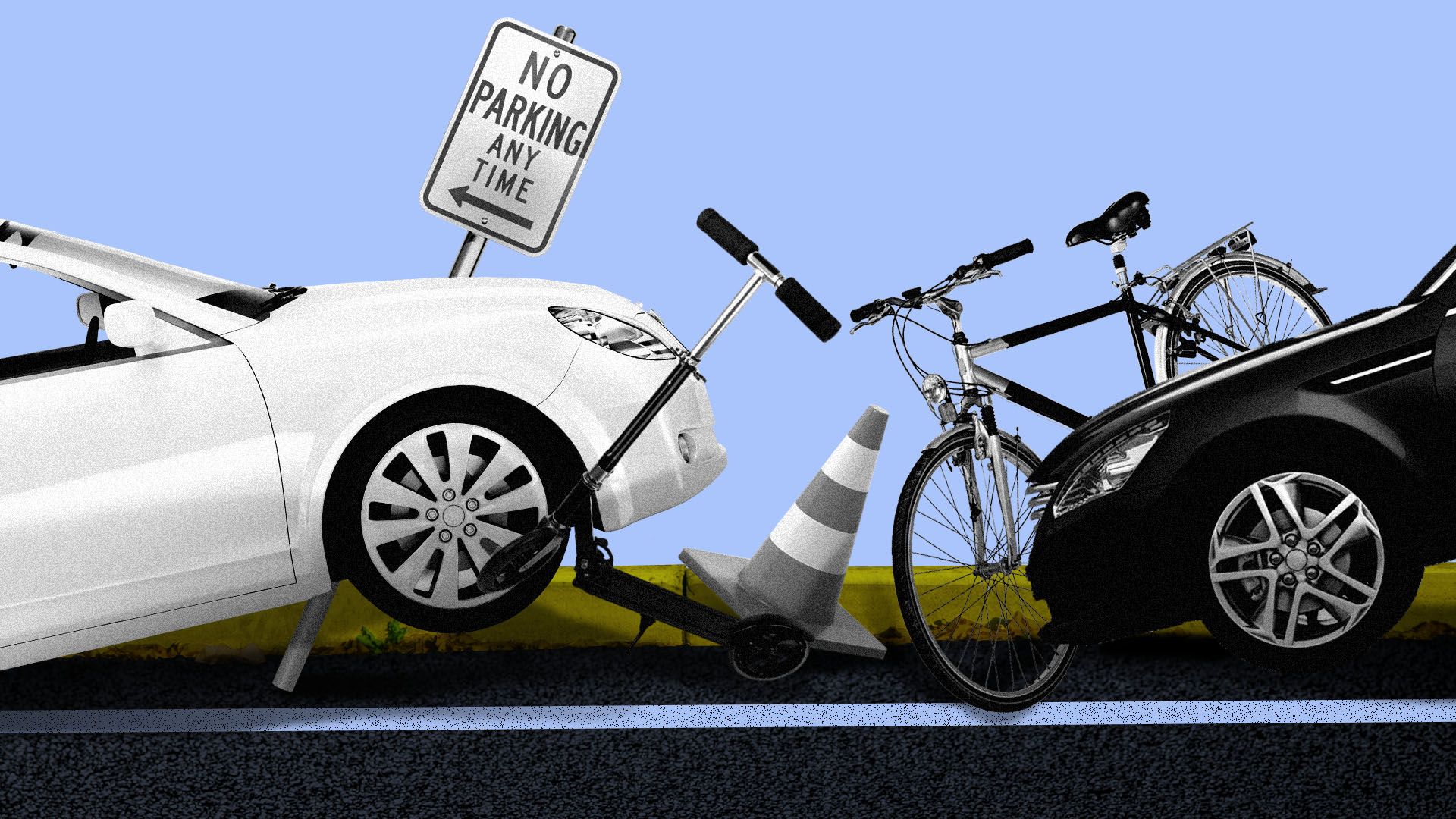
Illustration: Sarah Grillo/Axios

The lowly curb has become a coveted piece of urban real estate.

It's also a chaotic mess thanks to exploding demand for street-side access — by hordes of delivery trucks, taxis and ride-hailing services; electric bikes and scooters; city buses; pedestrians; construction crews; garbage trucks; parked cars; and meters.

"Not only are more people entering and leaving the curb, but we're also putting more stuff on curbs. That 2-foot zone is getting really crowded."
— Harriet Tregoning, World Resources Institute's Ross Center for Sustainable Cities

State of play: This mismatch of supply and demand has spurred cities and suburbs to think about treating curbs like a public utility and charging for access to them. That includes designating more zones for ride-hail pickup and drop-off, deciding where e-bikes and e-scooters should dock — and charging more when demand is high.

Enter tech: A slew of startups see a golden opportunity to restore order to the curb with maps, data, sensors and apps.

  • CurbFlow has entered a 3-month pilot project with Washington, D.C.'s Department of Transportation to monitor curbside parking.
  • Passport, a curbside payment software platform, has pilots in Charlotte, Detroit and Omaha to analyze scooter usage patterns to determine how to charge for curb space.
  • Inrix, an analytics firm, partnered with nonprofit Open Transport Partnership’s SharedStreets to create a standard for street-level data, including curbs.

Be smart: As a public right of way, curbs are becoming a kind of network interface for new technology and transportation options.

  • Cities need to know how much of this prime infrastructure they actually have and how it's used in real time. Most cities don't have that information, because they've never actually needed it.

For example: Coord, a New York-based startup that spun out of Alphabet's Sidewalk Labs, wants to make curbs more productive — i.e., serving the most people per unit of time per length of curb. To do that, it's providing a digital database of curbs to cities.

"We're seeing a lot of cities reallocate curb space away from parking into, for example, docks for bikes. That's an easy example of improving curb productivity by serving a lot more people in that space with those bikes than you would be with just the single parked car."
— Coord CEO Stephen Smyth

Yes, but: There are trade-offs. Allocating space to e-bikes may mean fewer spaces for residential permit parking. A designated ride-hail passenger drop-off zone may take up space once used for freight and e-commerce delivery trucks.

  • Eventually, autonomous vehicles will demand a piece of the space, too.
  • "On most streets, there's just not enough right-of-way to give everyone — buses, bikes, scooters, pedestrians, cars — a protected zone," Tregoning says.

The irony: These new tech startups are cropping up to solve the curb congestion problem that was exacerbated by the last wave of gig-economy-focused tech startups, including Uber, Lyft, DoorDash, Postmates, Bird and Lime.

The bottom line: "It’s not just about curb congestion," said Jim Barbaresso, of HNTB, an infrastructure design firm. "It’s really about serving all modes in new and dynamic ways that enrich the urban experience, while also providing a safer and more accessible transport system."

2. Sidewalk Labs' "dynamic curb" vision for Toronto

Illustration of curb wiggling

Illustration: Rebecca Zisser/Axios

The narrow curb zone is such a hot commodity — and such a headache — that Sidewalk Labs wants to redesign it altogether.

The big idea: In an ambitious and contentious bid to redevelop Toronto's waterfront neighborhood, Alphabet-owned Sidewalk Labs proposed "dynamic curbs" designed to be flexible spaces that respond to real-time traffic conditions.

How it works: The conventional cement ridge would disappear, to be replaced by lighted pavement that would direct pedestrian, cyclist and vehicle paths "on-the-fly, helping neighborhoods recapture flexible street space for public use in a clear and safe way," per the proposal.

  • A "mobility management system" would set pricing based on demand and publish pricing and schedule data to third-party apps.
  • During rush hour traffic, curb space would be priced high. All vehicles would pay a low fee to access the curb, with higher charges for those who wait more than 5 minutes at the curb.
  • During low-demand times, the curb zone may be repurposed for wider sidewalks or pop-up street fairs. Pavement lights and signs would signal priority pickup and drop-off areas and signal which areas are off-limits for cars.

Sidewalk Labs also envisions underground drop-off and pickup zones for shared fleets or autonomous vehicles, cutting down on street-level curb idling and double parking.

  • An underground network of tunnels would deliver freight packages — and carry away trash — via "smart containers" traveling on self-driving dollies. Sidewalk Labs claims this system would reduce street-level truck traffic by 72%.

The impact: Sidewalk Labs' Willa Ng predicts urban curbs will soon have to handle 8 times the current capacity.

  • Even though Sidewalk Labs' plan aims for 77% of trips to be made by modes other than private cars, Ng expects transportation companies like Uber and Lyft will be heavily used.
"We're putting stress on curbs like never before, but most of curbs in cities are underutilized. If we can actively manage it and set some policies to operate that curb, we can get more bang for the buck."
— Willa Ng, Sidewalk Labs director of mobility, streets

What's next: Toronto officials are still vetting the overall plan.

3. How Uber and Lyft add to congestion

Data: Fehr & Peers for Uber and Lyft; Chart: Harry Stevens/Axios

Since we're on the topic of congestion, earlier this month, Uber and Lyft released a consultant's study they commissioned on how much their services are adding to vehicle miles traveled (VMT) in several major metro areas, Axios energy reporter Ben Geman writes.

Why it matters: The analysis arrives amid wider research showing how the growth of ride-hailing is adding to congestion.

  • The chart above shows the study's conclusions about Uber and Lyft's combined contributions to VMT.
  • That's important, because more VMT makes it harder to cut carbon emissions from transportation.

Uber and Lyft officials, in blog posts (here and here), said they're committed to working with cities on the topic.

  • They also argued that they're a small part of the problem and that personal and commercial vehicles make up the majority of VMT in the 6 regions studied.

But, but, but: Populus CEO Regina Clewlow, whose company provides a transportation data analytics platform for local governments, said increased VMT doesn't tell the whole story about ride-hailing's effect on congestion.

  • "[T]he other important element (which requires coordination with cities), is that they stop wherever they want to, which disrupts the flow of traffic. This type of driving behavior is substantially different from the driving behavior of personally owned vehicles," she said via email.

Separately: In a July report, the Metropolitan Area Planning Council in Boston estimated that the net carbon footprint from ride-hailing added about 0.5% to the total carbon emissions for all passenger transportation across Massachusetts in 2018.

  • "If growth in ride-hailing emissions continues unchecked, it will make it very difficult for the state to meet its emissions reduction targets," the report said.

4. Unconvinced about congestion pricing

Manhattan traffic

Morning commute on a busy Manhattan street. Photo: Spencer Platt/Getty Images.

How much cities should charge vehicles to drive on city streets and who should have to pay is the center of political debates, Chris Teale writes for Smart Cities Dive.

Driving the news: New York City is about to become the first to charge Manhattan drivers a congestion toll. Fees collected would fund public transit and infrastructure improvements.

The whole story is worth a read, but the disconnect in public opinion is what stuck out to me the most.

  • A poll by HNTB found 70% of Americans are willing to pay higher tolls to support infrastructure investments.
  • But a recent poll by Quinnipiac University found NYC voters oppose congestion pricing by 13%, even though 62% were displeased with the city's subway service.
  • In D.C., a Washington Post/George Mason University survey found 63% of D.C.-area residents oppose congestion pricing.

Bottom line: "[C]ity leaders likely need to do more to show people the benefits of congestion pricing," Teale wrote.

Go deeper:

  • Free roads are not really free: Can cities make congestion pricing equitable? (Smart Cities Dive)
  • New York's high-cost traffic war (Axios)
  • Making cars pay to drive on the roads (Axios)

5. How cities are cutting down on light pollution

View of the U.S. at night with city lights.

View of the U.S. at night. Photo: NASA via Getty Images

As cities invest in technology upgrades, they have an opportunity to reduce light pollution, which impacts 99% of people in the U.S. and Europe, Karen Lightman writes for Axios Expert Voices.

The impact: Light pollution — including from streetlights that cast excessive light — is associated with sleep deprivation, impaired daytime functioning and obesity.

What's happening: Cities are making strategic investments, including updating streetlights to reduce the span of light and installing energy-efficient LED technology.

  • Middletown, Ohio, recently announced a plan to convert 2,000 streetlight heads to LED, which will save the city $359,000 in energy and maintenance costs each year.
  • Wilmington, Delaware, has explored retrofitting streetlight fixtures with sensor technology that could collect air quality, weather and noise pollution data.

But, but, but: LED deployment is not the end-all, be-all solution. At one point, Davis, California inadvertently over-lit the city with LED lights.

What to watch: Cities are exploring other tactics.

  • Asheville, North Carolina, has an ordinance that limits restaurants' outdoor lighting.
  • Hollywood, Florida, has an ordinance requiring oceanfront properties to dim their lights at night to avoid interfering with sea turtle mating and migration patterns.

Karen Lightman is executive director of Metro21:Smart Cities Institute at Carnegie Mellon University.

6. Urban files

Miami causeway over water

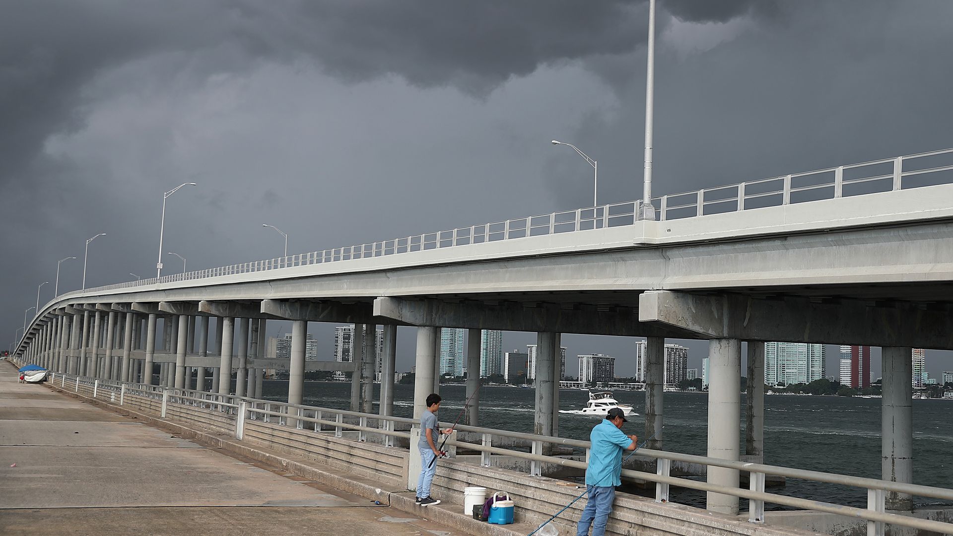
The Rickenbacker Causeway, connecting Miami to nearby barrier islands, is vulnerable to disruptions due to its exposure to climate change. Photo: Joe Raedle/Getty Images.

  1. Life in Miami on the knife's edge of climate change (David Campany — New Yorker)
  2. Amazon turns Northern Virginia into country’s most competitive home market (Prashant Gopal — Bloomberg)
  3. Welcome to housing Twitter, the shoutiest debate on the internet (Eillie Anzilotti — Fast Company)
  4. A city planner makes a case for rethinking public consultation (Sarah Holder — CityLab)
  5. Did Scoot ‘redline’ SF neighborhoods? Chinatown group says ‘we asked for it’ (Joe Fitzgerald Rodriguez — SF Examiner)
  6. Nipsey Hussle understood cities better than you. Why didn’t you know who he was? (Sahra Sulaiman — Streetsblog LA)
  7. Cities asked Ring to share ‘registry lists’ of customers who bought surveillance cameras (Caroline Haskins — Vice)

7. 1 🌳 thing: Green space boosts mental health

Chicago downtown skyscrapers cityscape from Lincoln park, Illinois

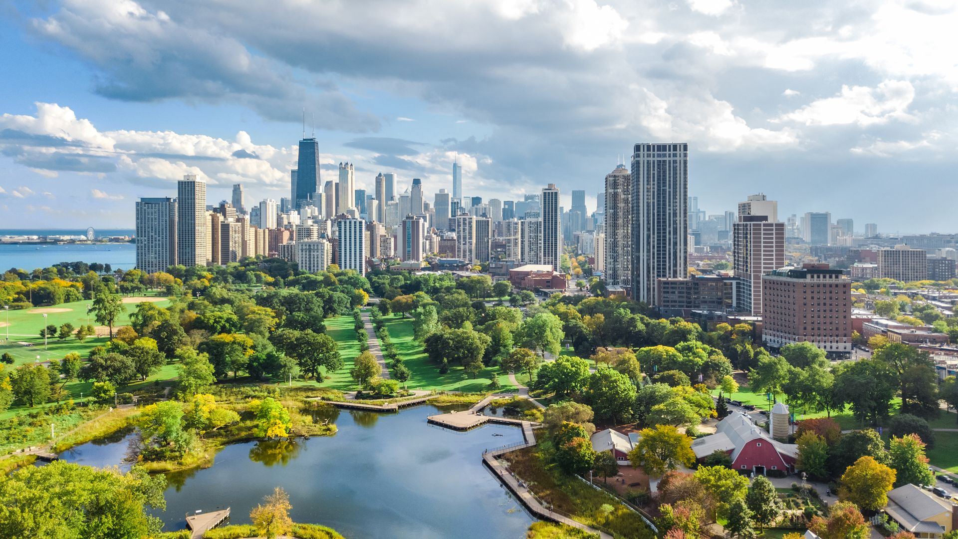
Chicago. Photo: JaySi/Getty Images

Plenty of governments add green space to improve physical health. Few, however, consider the psychological benefits these spaces provide.

Driving the news: Research published in the latest issue of Science Advances explains the growing evidence that suggests contact with nature can improve psychological well-being and reduce risk factors for some types of mental illness.

  • For example: The value of mental health benefits was calculated to be 7% of the total economic benefits of London parks, amounting to £6.8 billion ($8.3 billion) over 30 years, per a report by VividEconomics.

At the same time, however, opportunities to experience nature are decreasing rapidly as more and more people move into cities around the globe.

  • "The repercussions of these choices on mental health may add up to be quite significant on a population level" over the coming decades, the researchers wrote.

Go deeper: L.A. hires first ever forest officer (Smart Cities Dive)

See you next week!