Storms unleash deadly tornadoes in Midwest, South amid "catastrophic" flooding threat

Add Axios as your preferred source to
see more of our stories on Google.
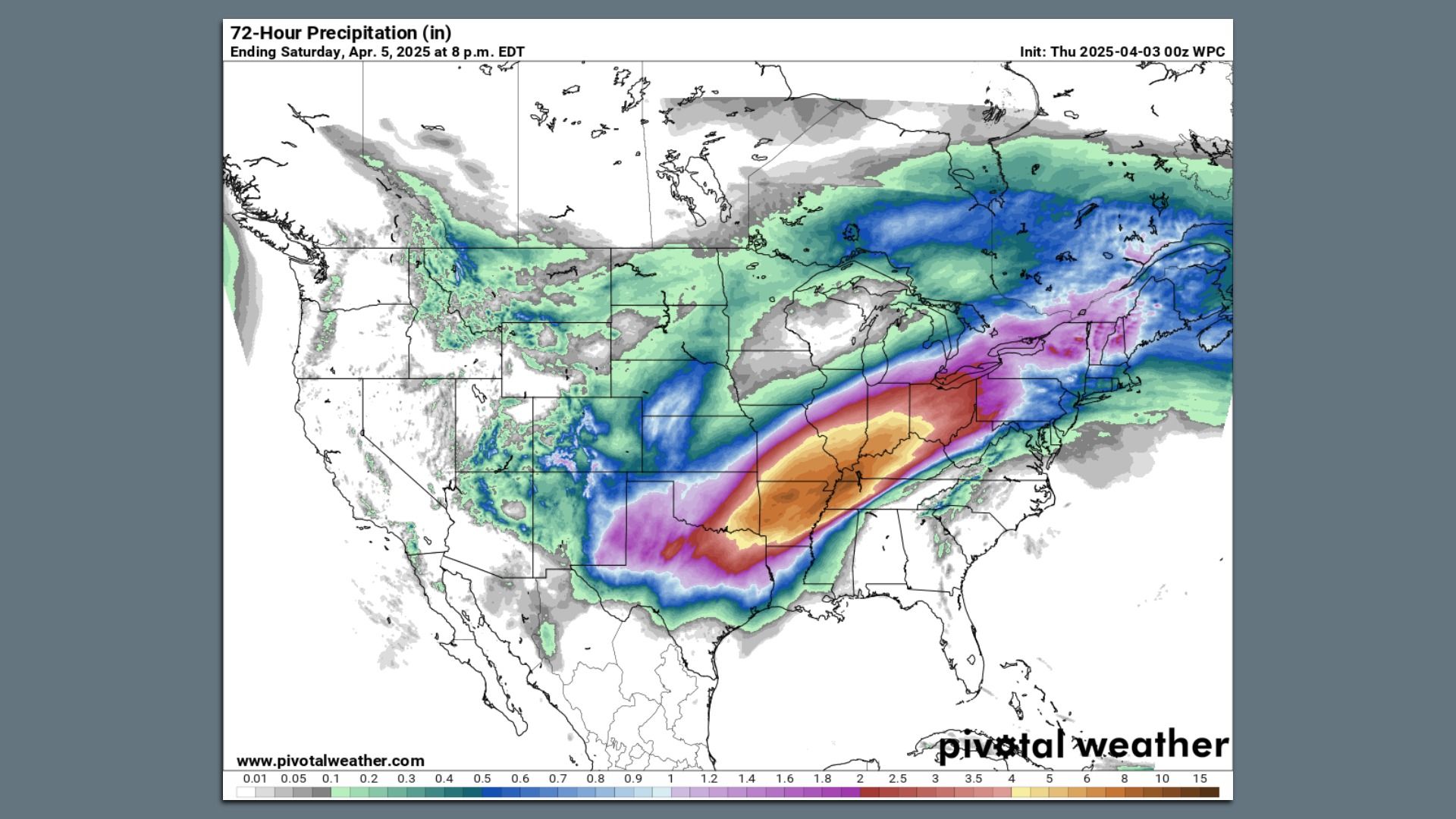
Map showing forecast rainfall totals across the Lower 48 states through April 5. Image: Pivotal Weather/NOAA
Severe storms are sweeping the U.S. South and Midwest, spawning damaging tornadoes and causing flooding in multiple states into Thursday, when at least four people were reported dead.
The big picture: The National Weather Service warned the "powerful Spring storm system will bring a barrage of life-threatening weather hazards" to parts of the Lower Ohio Valley and Mid-South Thursday through at least Saturday.
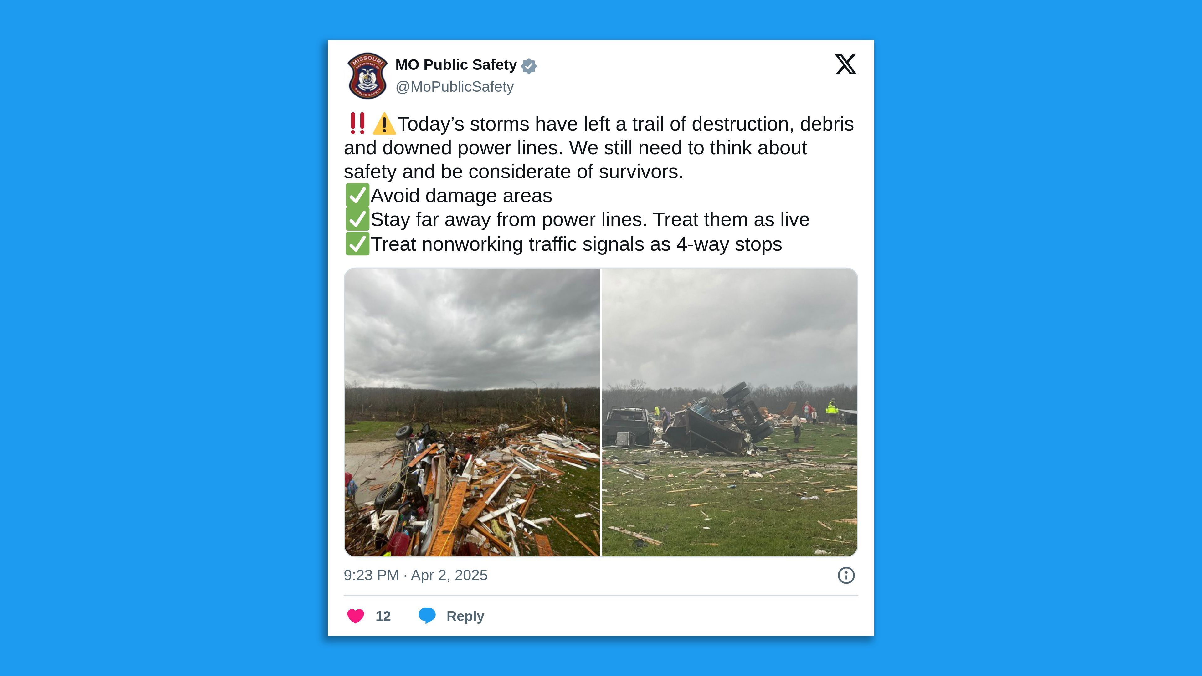
- Tornado damage was reported in at least four states and officials said a tornado injured four people in western Kentucky.
Threat level: In Arkansas, Gov. Sarah Huckabee Sanders declared a state of emergency ahead of the storms to provide funding in response to the severe weather. "We have reports of storm and tornado damage from around the state," she said on X Wednesday night.
- An EF-1 tornado in Vernon County, Missouri, on Wednesday morning "knocked over" eight train carriages, damaged several homes, "numerous businesses" and multiple trees, the National Weather Service's Springfield office said on X.
- Tornado damage was also reported in the Potosi area of Washington County, Missouri, some 72 miles southwest of St. Louis, on Wednesday evening. And storm damage was reported near Brownsburg, Indiana, where a tornado warning was in effect.
- Meanwhile, the NWS' Louisville, Kentucky, office said on X early Thursday a tornado was "on the ground, passing the I-64/I-265 interchange," and its Paducah office announced earlier its staff were sheltering in place:
Zoom in: The force of the storms knocked down trees and power lines, leaving an estimated 188,000 customers without power in Indiana. In Evansville, Indiana, video shared to social media captured power lines on fire.
- Rainfall totals from the dangerous flooding could match several months' worth of April rain in just four to five days in the hardest-hit areas. Roadways were flooded in Indianapolis late Wednesday and a local reporter shared images of submerged vacant cars.
- The NWS warned of an "increasingly significant setup" with the potential for "catastrophic" flooding in the hardest-hit regions and said Wednesday was "only the beginning of a multi-day catastrophic and potentially historic heavy rainfall event."
- It forecast rainfall totals that could exceed 15 inches in some locations through Sunday, describing it as an "extreme flooding scenario."
- Forecasters were closely watching for rainfall adding up in the Mid-South, particularly across northeastern Arkansas, northwestern Tennessee and western Kentucky.
The NWS forecast office in Memphis warned of "Generational flooding" in northwestern Tennessee, saying on X, "This is a rare, high-impact, and potentially devastating event."
- The NWS in Little Rock issued a "particularly dangerous situation" flash flood watch with the wording: "A heavy rainfall event of this magnitude falling within 4 days is an event that happens once in a generation to once in a lifetime."
- Forecasters there warned that areas that have not flooded before are at risk during this event.
Context: Extreme precipitation events are becoming more common and severe due to climate change, as warmer air temperatures hold more moisture.
- A new analysis from the nonprofit research group Climate Central found that heavy precipitation extremes are increasing in frequency in all regions of the country, though there is greater variability at the local levels.
- A marine heat wave in the Gulf of America (renamed by the U.S. from the Gulf of Mexico) and the Caribbean — a phenomenon increasingly tied to climate change — is also a factor, since this area will be the moisture source region for the heavy rainfall.
In another sign of the event's unusual nature, there is the potential for some spots to set records for the amount of precipitable water in the atmosphere.
- This is a way of measuring the precipitation that would result if all of the moisture in a column of air were to condense and fall as rain.
The extreme weather comes amid the Trump administration's push to give states the lead role in disaster response and recovery, potentially dissolving FEMA.
What we're watching: Where the heaviest rainfall sets up, and how severe the ensuing flooding gets.
Editor's note: This story was updated with additional developments.
Sareen Habeshian and Rebecca Falconer contributed reporting.
