Polar vortex-tied cold outbreak pushes into U.S. from the Arctic

Add Axios as your preferred source to
see more of our stories on Google.
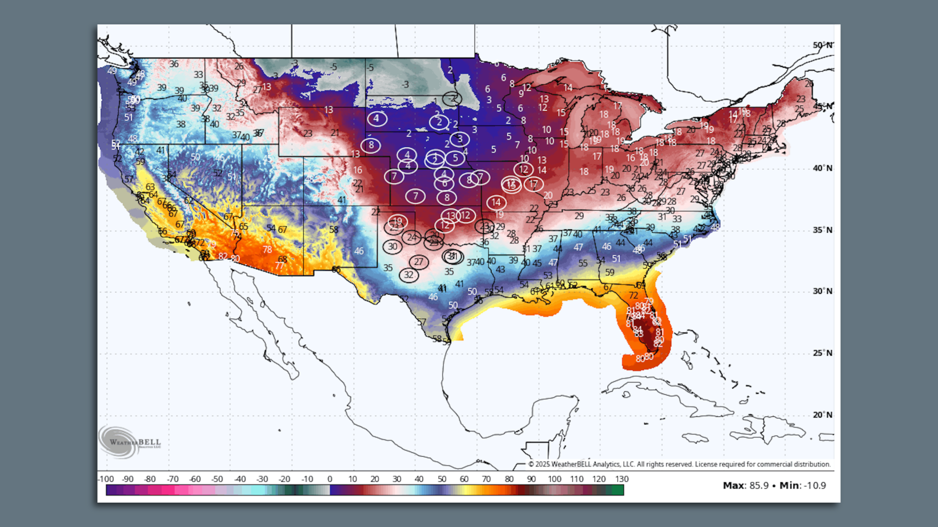
Forecast high temperatures on Feb. 19, showing daily record cold maximum temperatures in circles. Image: Weatherbell.com
A week-long, unusually cold Arctic outbreak will bring frigid conditions to most locations east of the Rockies starting today. For some locations, this could be the coldest air so far this season.
Why it matters: This event is likely to be more intense than the two previous polar vortex-related cold snaps in the U.S. so far this winter, according to University of Oklahoma meteorologist Jason Furtado.
Threat level: The Arctic air is likely to send temperatures plunging to 35 to 50 degrees Fahrenheit below average for mid-February across the Upper Midwest and Plains states, with the cold barreling south and east through the end of the week.
- The National Weather Service is warning of "high confidence for record-breaking cold" beginning Sunday and lasting through the week. The coldest air is destined for the Upper Midwest, Plains and South Central states, per the NWS.
- The cold air is forecast to infiltrate Texas by late in the week.
- NWS is calling for "widespread daily cold records from the Central Plains into the South Central U.S." between Tuesday and Friday.
- "Some locations may see their record coldest temperatures for so late in the season," the NWS stated via X, noting that 32°F temperatures would reach the Gulf Coast.
The East will also get significantly colder than average starting early in the week, the NWS stated.
State of play: Computer models have been trending colder with this event over time, as weather systems align across the Northern Hemisphere to drive extremely cold air south into the U.S.
- The NWS is cautioning that there will be a prolonged period of wind chills as cold as minus-60°F across the Plains, and sub-zero wind chills may reach as far south as Texas, Arkansas and Tennessee.
- There's also an increasing likelihood of at least one strong storm that may affect areas from the Southern Plains to the Mid-Atlantic late in the week.
- As of Monday morning, the likelihood was increasing that this storm would produce significant snowfall in the Carolinas and southern Mid-Atlantic, but miss the I-95 corridor from Washington, D.C. northward.
Between the lines: This event is consistent with some studies showing how human-caused climate change can favor winter weather patterns with a warmer than usual Arctic and colder than average midlatitudes.
By the numbers: Here is how the Arctic outbreak may affect a few particular cities this week, based on the NWS' forecasts. These are details for the coldest days in these locations
- Minneapolis: High of 1°F and a low of minus-19°F on Tuesday.
- Chicago: High of 9°F, low of 1°F on Monday.
- Des Moines: High of 1°F, low of minus-8°F on Tuesday.
- Dallas: High of 31°F, low of 19°F on Wednesday.
- Detroit: High of 17°F, low of 1°F on Tuesday.
The big picture: Experts told Axios that the cold outbreak is tied to the tropospheric polar vortex, as well as perhaps the vortex in the stratosphere.
- Other major weather players are influencing this, spanning from the tropical Pacific Ocean all the way to Greenland.
- The cold will occur at the same time as the Arctic sees unusually mild conditions, and a strong high pressure area and milder-than-average air takes over in Alaska, according to Judah Cohen, a meteorologist at Atmospheric and Environmental Research.
Zoom out: The vortex is an area of low pressure with winds swirling counterclockwise around it .
- It usually keeps the coldest air bottled up over the Far North.
Yes, but: In this case, there is more to it than just the polar vortex.
- Multiple factors will allow Arctic air to pour across the U.S.-Canada border, including a so-called "blocking pattern" over Greenland and "a spike in Arctic temperatures," Cohen told Axios in an email.
- One metric measuring the uniqueness of this coming weather pattern is at five standard deviations from the average, "which has to be relatively rare," NOAA's Amy Butler told Axios.
The intrigue: Butler was referring to the pattern of air pressure over the Arctic and the North Atlantic, known as the Arctic Oscillation, or AO.
- When the AO is in its negative phase, it tends to favor warmer than average Arctic temperatures, and a surge of cold air for the midlatitudes.
The bottom line: This polar vortex-related cold snap looks to be historic.
This story was updated with new forecast details on Feb. 16.
