Polar vortex-tied cold snap to grip the U.S. next week

Add Axios as your preferred source to
see more of our stories on Google.
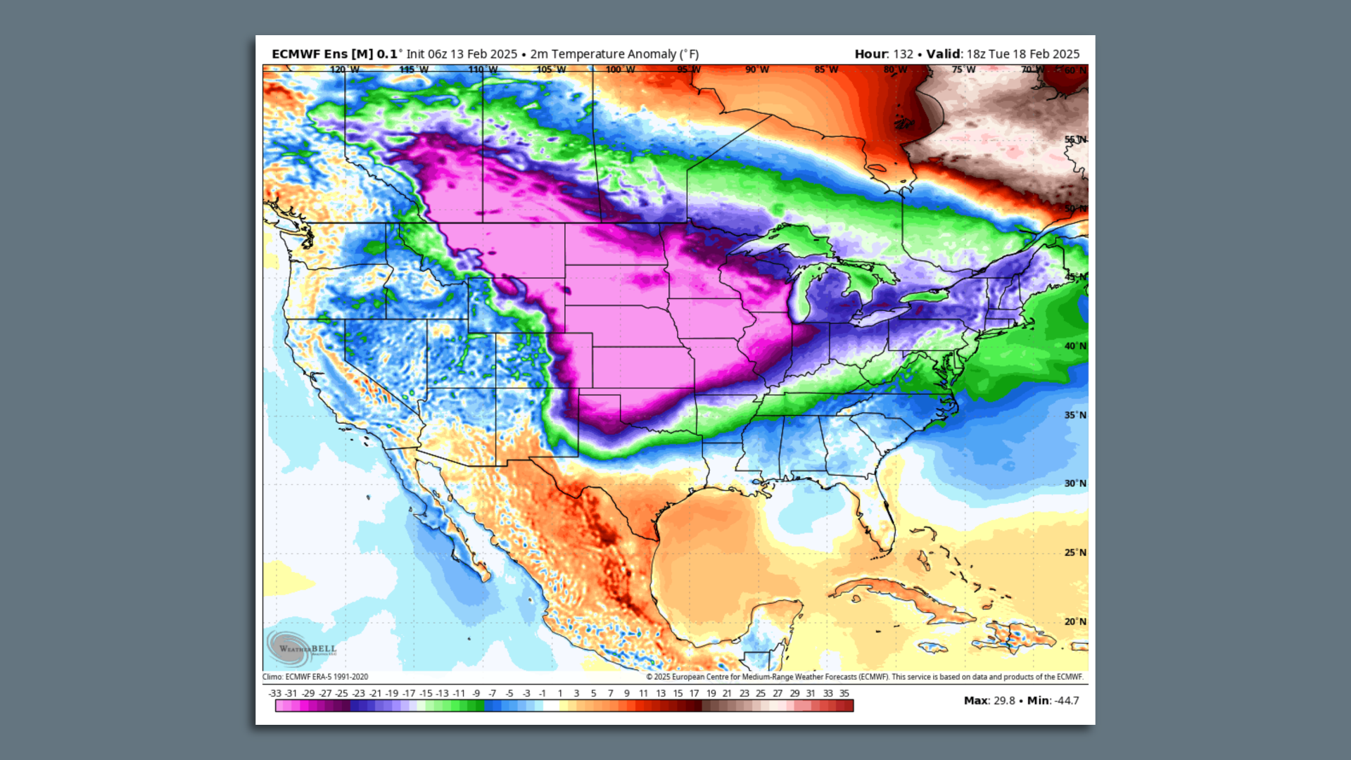
Computer model projection of temperature anomalies across the U.S. during the Arctic outbreak on Feb. 18. Image: Weatherbell.com
A weeklong, polar vortex-related Arctic outbreak rivaling any seen so far this winter is slated to bring frigid conditions to much of the U.S. east of the Rockies next week.
Threat level: The Arctic air is likely to send temperatures plunging to at least 30 degrees below average for mid-February across the Midwest and Plains states, with the cold moderating some as it barrels east through late week.
- The National Weather Service is zeroing in on two "surges" of cold, one on Sunday and another Wednesday into Thursday for the Plains states.
- Computer models have been trending colder with this event over time, putting some record minimum temperatures and record low daily highs within reach.
- The East will also get significantly colder than average starting early in the week, the NWS stated in a forecast discussion.
The big picture: Experts told Axios that the cold outbreak is tied to the tropospheric polar vortex, the polar vortex in the stratosphere and other major weather players spanning from the tropical Pacific Ocean to Alaska, all the way to Greenland.
- This event is likely to be colder than the earlier polar vortex cold snaps so far this winter, according to University of Oklahoma meteorologist Jason Furtado.
- The cold will occur at the same time as the Arctic sees unusually mild conditions and a ridge of high pressure and milder-than-average air takes over in Alaska, according to Judah Cohen, a meteorologist at Atmospheric & Environmental Research.
- At the same time, the upper-level polar vortex will dip south, near the U.S.-Canada border.
Zoom out: The vortex is an area of low pressure that is a typical feature of the Northern Hemisphere's winter season, with winds swirling around it counterclockwise. It tends to keep the coldest air bottled up over the Far North.
/2025/02/13/1739466940320.gif)
Yes, but: In this case, multiple factors stand ready to allow Arctic air to pour across the U.S.-Canada border, including a stretched polar vortex, a so-called "blocking pattern" over Greenland and "a spike in Arctic temperatures," Cohen writes.
- These ingredients increase the odds of severe winter weather in the U.S., Europe and Asia, he said.
- Furtado said the blocking pattern is more expansive, existing across the North American Arctic region, directing colder air southward.
- According to him, conditions in the tropical Pacific also are helping to reinforce the arrangement of weather systems across North America now.
Context: Studies suggest human-caused climate change may be making polar vortex shifts more likely, but this is an area of active research.
- It also does not quite match up with the multifaceted event about to take shape.
- Cohen has published research tying rapid, human-induced Arctic warming to a chain of events, including disappearing fall sea ice in the Barents and Kara seas and increased snowfall in Siberia.
Friction point: This area of climate science is hotly contested, though it is generally agreed that rapid Arctic warming is having an effect on the region's winters that can alter weather thousands of miles away.
