Polar vortex-driven Arctic blast to yield historic southern snow

Add Axios as your preferred source to
see more of our stories on Google.
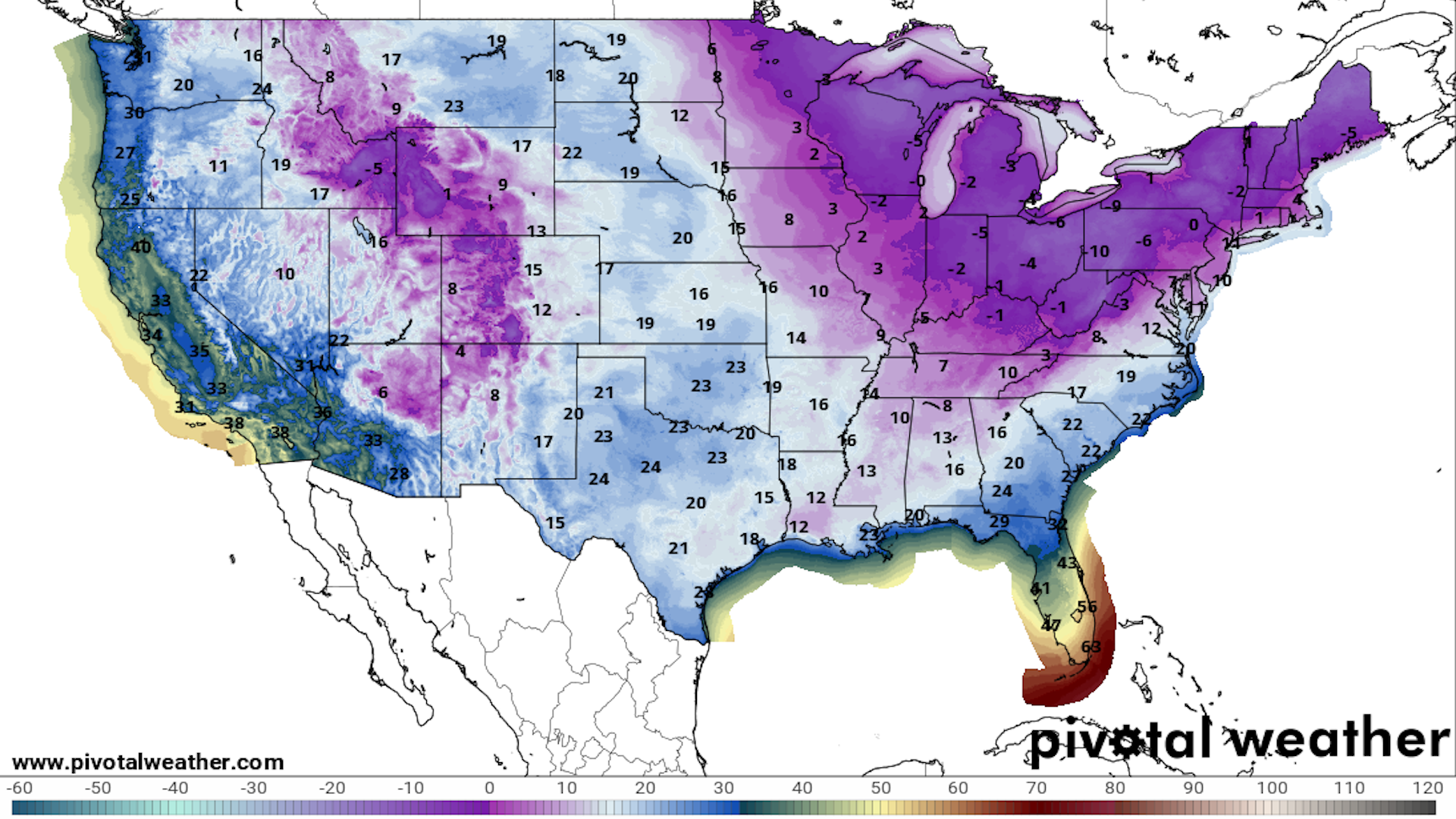
Map showing NWS forecast for low temperatures across the U.S. on Tuesday morning, Jan. 21. Image: Pivotal Weather
Editor's note: Here's the latest on the winter storm.
A historic winter storm is poised to produce potentially record-breaking snows from coastal Texas to northern Florida late Monday into Tuesday. The event comes as an Arctic blast affects more than half the U.S. population.
Threat level: Cities from Houston to New Orleans to Jacksonville may come to a standstill for extended periods due to the wintry precipitation.
- Winter storm warnings are in effect from the South Texas coast north and east to northern Florida. Elsewhere, more than 200 million people were under some type of cold weather warning on Monday morning.
- The National Weather Service is warning that the cold air is hazardous to health, with the threat of hypothermia and frostbite for those exposed to the elements for long in the northern Plains, parts of the Midwest and the East.
- In the coldest regions, wind chills reached minus-50°F on Monday morning.
State of play: The southern snow could break records. The National Weather Service forecasts 3 to 6 inches of snow is forecast for the Houston metro area.
- Schools are closed in Houston on Tuesday, and Houston's two busy airports are set to close overnight Monday and remain so on Tuesday.
- If the city receives more than 4.4 inches, this storm would become the second-biggest snowstorm on record there, beating a storm that occurred in 1960.
- Updated forecasts on Monday afternoon showed that amount is increasingly within reach.
Parts of Louisiana stand to potentially receive up to 10 inches of snow, with 5 to 7 inches or more forecast to accumulate in New Orleans. That would rank in the top 5 snowstorms on record for the city.
- Snow is also forecast from coastal Alabama, Mississippi and southern Georgia to northern Florida, potentially setting milestones along the way.
- Cold weather warnings and advisories also extend into northern Florida.
Context: The factors behind this noteworthy cold outbreak include a strong high pressure area or "ridge" in the jet stream across the eastern Pacific north to Alaska. Meanwhile, there's a dip, or "trough," in the jet stream across central portions of the U.S.
- In fact, the trough encompassed most of the contiguous U.S. as of Monday morning.
- This is allowing Arctic air to surge southward to the Gulf Coast.
- Also, in the upper atmosphere, the polar vortex is currently becoming "stretched" from north to south across the North Pole.
- It is expanding southward and helping to promote the flow of air from northern Canada southward toward the continental U.S., said Judah Cohen, a meteorologist at Atmospheric & Environmental Research.
Zoom out: The polar vortex in the stratosphere is altering the jet stream one atmospheric layer down, in the troposphere. This is where most weather takes place.
- This interaction between the polar vortex and the jet stream may be favoring the strong area of high pressure over Alaska and downstream trough, according to Amy Butler, a researcher at NOAA, and Simon Lee of the University of St. Andrews.
- Both researchers said this interaction is likely to be more short-lived than what happened during the infamous polar vortex winter of 2013-2014.
Over longer timescales, studies suggest polar vortex shifts may be more likely due to human-caused climate change, but this is an area of active research.
- Also, extreme cold is due to become less severe in a climate that is warming over time due to the burning of fossil fuels.
This story has been updated to include the latest forecast snowfall totals.
