Arctic blast tied to polar vortex puts U.S., Europe in deep freeze

Add Axios as your preferred source to
see more of our stories on Google.
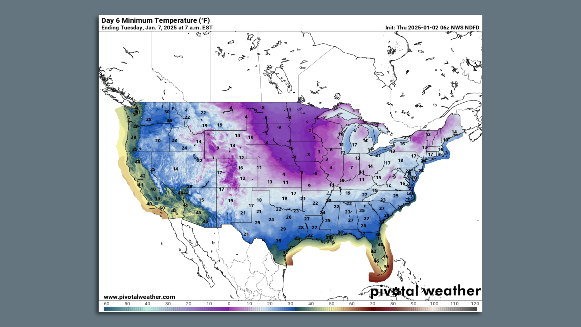
Map showing forecast minimum temperatures on Jan. 7 as Arctic air moves into the U.S. Image: Pivotal Weather/NOAA
An Arctic outbreak featuring punishing cold weather is beginning across much of the U.S. at the same time that Europe prepares for plunging temperatures.
Why it matters: About three weeks of cold east of the Rocky Mountains — potentially accompanied by major winter storms — will boost natural gas prices, pose a risk of power outages and disrupt travel.
Threat level: The cold will hit the U.S. in waves, with the first moving in this week, a second early next week on the heels of a significant Plains to Mid-Atlantic winter storm, and additional ones after that.
- Each push is likely to be colder than the one preceding it.
- By early next week, daily high temperatures may be stuck in the single digits across parts of the Midwest, with the possibility of temperatures dropping to 32°F all the way to the Gulf Coast.
- In the East, highs in Washington, D.C., may not get much above freezing for several days in a row during the Jan. 4-10 period, with the possibility of even colder weather arriving after that.
- Before this event ends, residents of at least 30 states will have been affected. Millions will see increased heating bills as natural gas prices spike, and some could be affected by rolling blackouts during the coldest periods.
Zoom in: The polar vortex is an area of low pressure that exists over the Arctic at the upper levels of the atmosphere, in the stratosphere, during winter.
- Strong winds circulate counterclockwise around this low pressure area, and build up and trap some of the coldest air in the Northern Hemisphere across the Arctic.
- When these strong winds slacken, parts of the polar vortex can detach and meander southward, bringing ultra-cold air to southern Canada, the U.S. and Europe.
- This occurred back in the winter of 2013-14, but this new event is distinct.
- Instead, the stratospheric polar vortex is becoming "stretched" from north to south across the North Pole.
Between the lines: The stretched vortex may be setting in motion a complicated board of atmospheric chess pieces that include a strong area of high pressure over Greenland.
- That stops storms from heading out to sea and directs cold weather in the eastern United States.
- This setup, known as a Greenland Block, along with other, broader patterns of air pressure over the Arctic and North Atlantic, also tends to favor unusually cold conditions in northern Europe.
- The Greenland Block is combining with a high pressure area stretching from California to Alaska to promote air to flow from Siberia, across the pole, and southward toward the continental U.S.
This cross-polar air flow can translate to temperatures of about 20°F to 30°F below average for this time of year.
What they're saying: "It is the stretching of the polar vortex that allows colder temperatures normally confined to the Arctic to spread much further south of normal," said Judah Cohen, a meteorologist at AER who researches Arctic climate change and the polar vortex, via email.
Zoom out: Uncertainty remains about how cold the U.S. will get, along with the timing and occurrence of any major storms beyond the first one this weekend.
- Some computer models have backed off initial predictions of truly historic cold that would rival outbreaks dating back several years, if not longer.
- The possibility still exists of a lobe, or piece, of the tropospheric polar vortex diving south from Canada and into the South and Southeast, sending temperatures plunging well below the levels currently forecast.
- This would lead to extremely cold conditions, most likely during the Jan. 9-Jan. 14 time frame.
- In such a scenario, some state power grids could struggle to keep up with demand as power plants deal with cold weather-induced reductions in generation, as occurred in Texas in 2021.
Context: Studies suggest polar vortex shifts may be more likely due to human-caused climate change, but this is an area of active research.
- Cohen, for example, has published research tying rapid, human-induced Arctic warming to a chain of events including disappearing fall sea ice concentrations in the Barents and Kara seas.
Friction point: But scientists are somewhat at odds over the extent to which shifts in the orientation of the polar vortex are driving this particular cold snap.
- Cohen points to the stretching polar vortex and long-term climate change as significant players.
- But Amy Butler, an atmospheric scientist at NOAA's Chemical Sciences Laboratory, told Axios she sees other factors as more significant drivers right now.
- "In this case, I'm not convinced that the polar vortex stretching is driving the cold," Butler told Axios via email.
- "To me, it seems more likely that the persistent blocking high over Greenland over the next few weeks, along with a building ridge off the coast of California, are working in concert to drive cold into the eastern US for an extended period of time," she said.
The bottom line: Regardless of the causal chain, extreme cold is on the way for more than 150 million Americans.
