Severe weather outbreak targets the South on Saturday

Add Axios as your preferred source to
see more of our stories on Google.
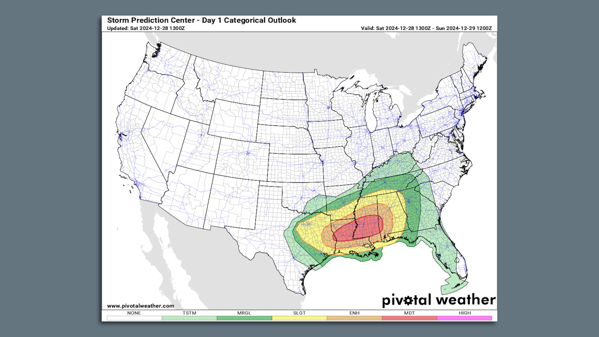
Map of severe weather risk categories for Dec. 28, including the "moderate risk" zone. Image: Pivotal Weather/NOAA
A severe weather outbreak, including long-lasting and intense tornadoes, is affecting a swath of the South on Saturday into Saturday night.
Threat level: The Storm Prediction Center has issued a rare "moderate risk" outlook, or level 4 out of 5 on the threat scale, for portions of Mississippi and Louisiana, indicating confidence in a potentially significant outbreak.
- Already, long-lasting, damaging tornadoes have struck southeastern Texas, including coastal sections of Harris County and near Port Arthur.
- Some of these circulations have persisted for more than 60 miles, with tornadoes on the ground for a significant portion of that distance.
- The text of the tornado warnings has included enhanced language, indicative of the threat level involved: "This is a particularly dangerous situation! Take Cover Now!" the NWS forecast office in Lake Charles, La. warned as one tornado sped towards southeastern sections of Port Arthur.
- Other tornadoes have been reported, along with damaging straight-line winds, hail and flash flooding in parts of Mississippi, Louisiana and Alabama.
The big picture: The NWS issued a high-end "Particularly Dangerous Situation" tornado watch for southeastern Arkansas, central and southwestern Louisiana, southwestern Mississippi and southeastern Texas until 9pm local time. The watch states the expectation for "numerous tornadoes" along with a few intense tornadoes of EF-2 strength or greater.
- This outbreak follows severe weather earlier this week in Texas, and is the result of a deep dip, or trough, in the jet stream that is pulling moisture from the Gulf of Mexico northward.
- The storm forming in eastern Texas and northern Louisiana is forecast to move northeast while intensifying, eventually making its way into the Ohio Valley, Northeast and Quebec by early next week.
At lower levels of the atmosphere, there is ample wind shear (winds that blow at different speeds and/or directions at different altitudes) present to support long-lasting, rotating thunderstorms that can produce an array of extreme weather hazards, including tornadoes.
Zoom in: About 2 million people live in the moderate risk zone, which includes the cities of Jackson and Hattiesburg, Mississippi, along with Alexandria, Louisiana.
- About 4.6 million people reside in an area designated as being under "enhanced risk" of severe weather, including the cities of Baton Rouge, Shreveport, Louisiana and Mobile, Lafayette and Tuscaloosa, Alabama.
- This region is in a level 3 out of 5 on the risk scale.
- New Orleans is in the "slight risk" zone, indicating a lower threat there, though a heavy rains and thunderstorms are still expected in the Big Easy Saturday afternoon into Saturday night.
Context: Although spring and summer are typically thought of as tornado season, the South and Southeast tends to see severe weather during the winter as well, since that is when strong storm systems form near the Gulf Coast.
- This yields collisions between warm, humid air to the south and cold, dry air to the north.
- Climate change affects the conditions in which thunderstorms form and may be leading to larger outbreaks, though fewer of them, by adding to the instability of the atmosphere while simultaneously cutting back on wind shear.
- However, when both ingredients are present in enough abundance, major outbreaks can occur, studies show.
Editor's note: This story has been updated with the latest conditions.
