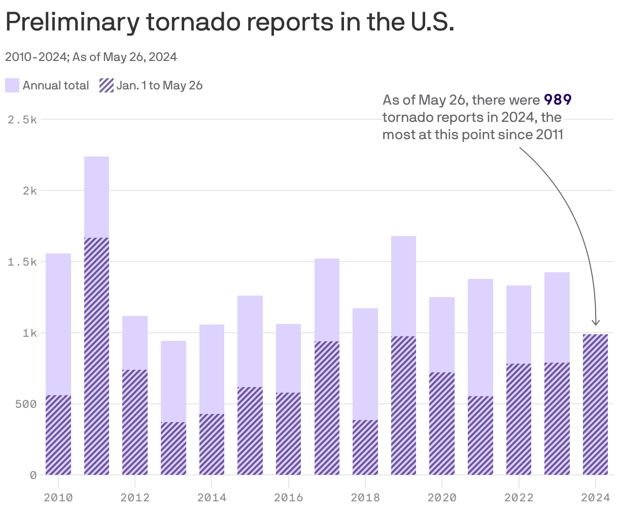
Tornado season is the second-busiest so far in the U.S., behind 2011

Add Axios as your preferred source to
see more of our stories on Google.
 Open embedded content from datawrapper.dwcdn.net
At least 25 people were killed as severe storms struck multiple states this weekend.
Why it matters: This year now sits at second place for reported tornadoes to date, behind 2011's record-setting year.
Zoom in: Damaging and deadly twisters occurred in Texas and Oklahoma Friday night, then moved eastward. Sunday night, tornadoes struck some of the same areas in Kentucky that were hit by the Mayfield tornado in 2021.
- Additional storms hit Monday and snarled Memorial Day flights up and down the East Coast.
Between the lines: Climate change is altering the environment in which severe thunderstorms and tornadoes form, in ways that raise the odds of sparking dangerous severe weather outbreaks.
- Such outbreaks may become more prolific, studies have shown, but may also decline in frequency.
- Tornado risks are already increasing beyond the traditional "Tornado Alley" region, and the destructive weather phenomena are becoming more variable each year.
- A 2021 study showed that as average temperatures increase, so do key ingredients for severe weather outbreaks, such as atmospheric instability.
The big picture: The repeat storms in the Plains, Mississippi River Valley and Ohio Valley this season are related in part to a stagnant, powerful heat dome over Mexico.
- All-time high-temperature records have been broken in Mexico and Central America, including Mexico City's all-time highest temperatures on record, and the heat has encroached into the U.S.
- Mexico's climate-change-worsened heat wave has turned deadly and threatens to dry up Mexico City's water supplies, perhaps as soon as a month from now according to some estimates.
- According to Climate Central's Climate Shift Index, the heat on May 27 that occurred from Houston southward throughout Mexico, was at least five times more likely to occur due to human-caused climate change.
- The repeating storms are also likely causing billions of dollars in insured losses, according to Steve Bowen of Gallagher Re.
By the numbers: This weekend, excessive heat warnings and heat advisories stretched from South Texas to New Orleans.
- Monday's heat index at Houston Hobby Airport reached 115°F, a scorching temperature that had never been reached before during May, and was last seen there in 1998, according to meteorologist Matt Lanza of TheEyewall.
- Severe thunderstorms featuring large hail and damaging winds struck the Dallas-Ft. Worth area on Monday and Tuesday, with storms knocking out 300,000 customers in the Houston area Tuesday, just weeks after a derecho left more than 1 million customers in the dark.
- State-wide on Tuesday afternoon, about 1 million customers were without power according to poweroutage.us.
- The jet stream flowing around this extreme heat and across the Central U.S. helped spark the severe weather. Such a weather pattern is known as a "ring of fire," with storms skirting the edges of the heat dome.
