Exclusive: Near Space Labs debuts ultra-high resolution Earth images

Add Axios as your preferred source to
see more of our stories on Google.

Illustration: Aïda Amer/Axios
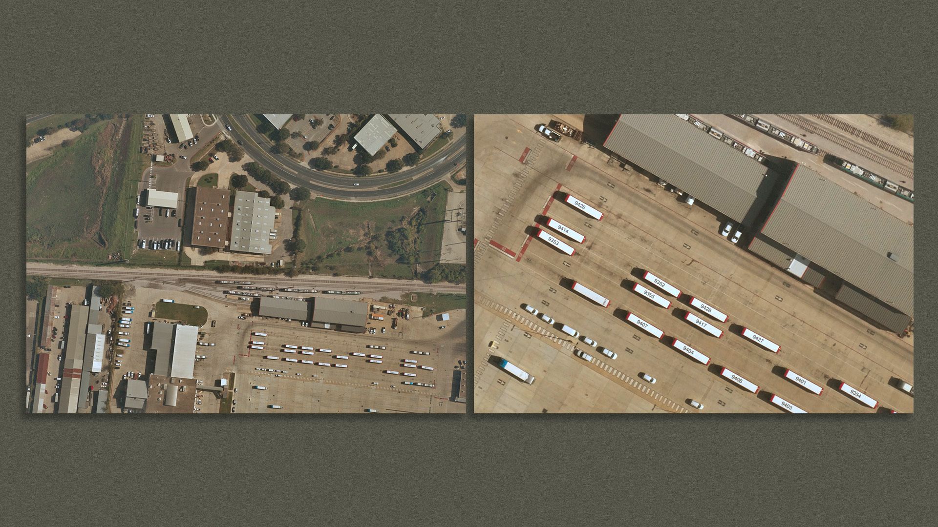
Near Space Labs, a Brooklyn-based Earth observing company, is making images of the U.S. available at the ultra-high, 10-centimeter resolution for commercial use beginning this week, the company tells Axios.
The big picture: This makes Near Space Labs the only company to offer imagery this detailed on the commercial market right now.
- One other company, Albedo, is planning to offer imagery at this resolution via satellites in 2023 or 2024. Most satellites whose imagery is commonly shared in the media, for example, have 30-cm resolution.
- In images with the new, higher resolution, one can pick out a soccer ball in a field.
Why it matters...The new optical imagery has many use cases relevant to climate and energy interests:
- Energy companies can monitor their operations, including pipelines and other infrastructure.
- For the insurance industry, which can quickly conduct damage assessments after extreme weather and climate events, and even write claims or underwrite policies remotely.
- First responders can track floods and wildfires.
- Environmental groups can keep tabs on environmental threats such as habitat destruction, or watch over industrial operations.
How it works: While most Earth-imaging firms, like Planet, Maxar and Skybox, opt to hitch a rocket to low Earth orbit, Near Space Labs has gone a different, and it says far more flexible, route: its equipment heads only into the stratosphere by hitching a ride aboard slightly more sophisticated versions of typical weather balloons.
- These balloons, known as Swiftys (a nod to the company's former name of Swiftera), climb to about 65,000 feet, above where most weather occurs.
- Here, software helps guide the balloon to the desired imagery target.
- The balloons, co-founder and CEO Rema Matevosyan told Axios, allows Near Space to charge less money than its rivals, and also keeps the company's environmental footprint low.
- Mobility companies can better write mapping software to enable self-driving cars to stay on the road, away from medians, large potholes and other obstacles.
The intrigue: Near Space Labs’ balloons are regulated more like a drone company, via the FAA, rather than as a space startup, which means they have fewer hoops to jump through to offer imagery at a resolution that used to be prohibited due to national security concerns.
- Each Swifty flight can capture 400–1,000 square kilometers of imagery, which the company says is the size of about 190,000 football fields.
- The company has operations in Texas, Arizona and California, and aims to deploy enough to offer 100 top cities in the country at 10cm resolution.
- The company has raised a total of $16.8 million so far, and Toyota Ventures is an investor.
What they’re saying: “Our mission is to make very high-res, highly-updated, Earth imaging universally accessible to whoever needs it, regardless of industry and budgets,” Matevosyan told Axios.
- “The resolution is a huge leap up. And that's going to be really important for certain types of applications,” Krystal Azelton, director of Space Applications Programs at the Secure World Foundation, who is not affiliated with the company, told Axios.
- But higher resolution doesn't always translate into more useful products, Azelton said.
- In addition, space-based imaging has the advantage of having higher revisit rates, she said, which allows for the production of a time series of images that can appeal to a broader array of customers.
Editor's note: The photo caption in this story has been corrected to note that both of the Near Space Labs images are in 10cm resolution, not 30 cm and 10 cm resolution as a company representative originally stated.
